
|
NORTH LINCOLNSHIRE - Barton-upon-Humber
South Bank Stroll
This walk sets off from in the shadow of the mighty Humber Bridge. The south bank of the Humber at Barton was the scene of many gravel and clay workings. Today the majority of these flooded pits have found new uses for recreational activities and nature, although there are still a brick works and tile works manufacturing their products in traditional ways.
Fact File
|
Distance
|
8Ẅ miles/ 13.5km
|
|
Time
|
4 hours
|
|
Maps
|
OS Explorer 281; Landranger 112
|
|
Start/Parking
|
Barton Water's Edge car park (free). Grid Ref: TA 030 231
|
|
Terrain
|
Paths, farm tracks, and lanes. Some wet ground in places. Just one hill up through South Ferriby
|
Grade
|
*** easy/moderate
|
|
nearest Town
|
Barton-upon-Humber
|
|
Refreshments
|
Water's Edge Visitor Centre and nearby the Ropery. Also pubs in the town centre
|
|
Toilets |
Water's Edge Visitor Centre
|
|
Public Transport
|
Stagecoach buses from Grimsby, Scunthorpe, and Hull plus local routes. Barton is also the terminus of the branch line trains from Grimsby.
|
|
Suitable for
|
all
|
|
Stiles
|
6
|
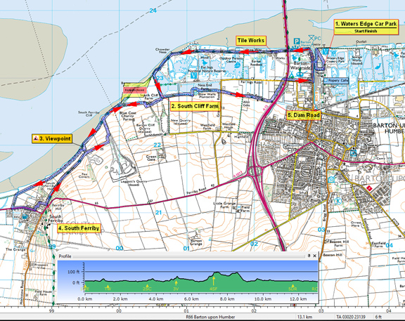

Route created using TrackLogs Digital Mapping
Image reproduced with kind permission of Ordnance Survey and Ordnance Survey of Northern Ireland.

- (Start) From car park head towards visitor centre for a view of Humber Bridge. Then walk back alongside Haven and cross footbridge. Turn right along Waterside Road towards Humber Bridge and round the corner pass the old Coastguard Station, the start/finish of the Viking Way. Follow the river bank path (Viking Way/Nev Cole Way) past tile works - note walls made from tiles - and past Far Ings Nature Reserve. Come to a small parking area at a lane end. Here turn left along lane following the re-routed Viking Way - the river bank ahead has been breached to allow wetlands to flood at high tides.
- (2ỳ mile/3.6km)
Turn right towards Cliff Farm. Continue ahead past barns where path is contained within fencing around buildings to a footbridge (& boggy area) and up onto flood-bank. Continue along flood-bank and rejoin river bank proper. Cross over track from the former Leggott's Quarry and continue along South Ferriby Cliff. At another disused quarry spoil tip, the path detours inland round field edge below the tip. At the top it is worth walking out to the edge of this tip which provides a good viewpoint over the River Humber towards North Ferriby. The path rejoins river bank on other side. Here a steep gully leads down to a 'beach' in the shelter of the low cliff and could make a pleasant spot for a break - if the tide is out!
- (3ỳ miles/5.2km)
Continue along the river bank path, which is less user-friendly now you have left the touristy areas behind. Ahead is the eyesore of the cement works beyond South Ferrby. Pass a seat and memorial stone and after a wooded area below South Ferriby Hall, a footpath sign by a sluice points away from river. Follow this track to the road. Turn left along pavement by the busy A1077 towards South Ferriby village. Here you face the only hill on this walk! You could keep to the pavement up the hill and round the corner, but to get away from the traffic go left along Farrishes Lane, next to the Post Office, and then turn up North End to emerge on Cliff Road opposite a pond.
- (4Ẅ miles/7.2km)
Now heading back towards Barton along Cliff Lane parallel to, but above your outward route. You arrive at the top of the spoil tip visited earlier but continue ahead along a track until at the disused Leggott's Quarry you must turn down to rejoin your outward route. Retrace your steps along the river bank and past South Cliff Farm, but at the lane corner continue ahead on a path along the south side of Far Ings Nature Reserve. Cross a minor road and continue past allotments until the way ahead appears to be blocked by the embankment of the A15 Humber Bridge approach road.
- (7ỳ miles/11.6km)
No worries, as a path has been created through trees below the embankment bringing you to Far Ings Road. Walk along roadside pavement under the A15 back into Barton. At the end of the road, the long brick building across the overgrown Barton Haven is the former Ropeworks, now the Ropewalk Arts Centre. To cross the Haven turn left along Waterside Road and in about 200yds cross by the footbridge, used at the start, to arrive back at Water's Edge Country Park. Now you have a choice of tearooms - either at the Visitor Centre or at the Ropery.
(15.2km/9Ẅmiles)
Along the Way

Don't miss the viewpoint from where you can look across the mile-wide Humber and watch shipping that still serves the inland port of Goole and elsewhere.
The Ropewalk alongside Barton Haven is almost a quarter of a mile long, and was initially part of a rope making factory. Opened in 1767, the factory eventually closed in 1989, and is now a regionally acclaimed centre for the arts, housing a gallery, a sculpture garden, coffee shop and a venue for film, theatre etc.
At the Water's Edge Visitor Centre, opened in 2006, you can discover more about the unique environment of the Humber Estuary and Wildlife by means of interactive displays, live images, games & other activities.
Interesting facts:
The Viking Way is a long distance footpath in England running 147 miles between the Humber Bridge in North Lincolnshire and Oakham in Rutland.
The 57 mile Nev Cole Way links Burton-upon-Stather with Nettleton. This Walk was devised by the Wanderlust Rambling Club of Grimsby, formed in 1932 by Nev Cole, to "celebrate his life, the creation of the Club and his friends in the Ramblers Association groups".
Arnold Underwood (Feb 2016)
|
