|
DERBYSHIRE PEAK DISTRICT - Baslow
'Derbyshire Dales Classic'
Explore the gritstone edges above Baslow, the wooded Padley Gorge, with its historic chapel, and the delightful Derwent Valley.
Fact File
|
Distance
|
20km (12˝ miles)
|
|
Time
|
6 hours
|
|
Map
|
OS Explorer OL 24 The Peak District (White Peak)
|
|
Start/Parking
|
Baslow car park
|
|
Terrain
|
Field & moorland, woodland & riverside paths & tracks
|
|
nearest Town
|
Chesterfield
|
|
Refreshments
|
Pubs in Baslow, near Longshaw, and at Calver Bridge.
|
|
Toilets |
Baslow
|
|
Public Transport
|
'Peak Bus' Sheffield - Baslow & Chesterfield - Bakewell |
|
Suitable for
|
all - with care on the 'edges'.
|
|
Stiles
|
8
|
- (Start) Leave the car-park, cross the green and then the main road at the pelican crossing. Continue up Eaton Hill road opposite as far as a triangular green, and there turn right up Bar Road. Once past the houses this becomes a walled track, which climbs steadily for about ˝ mile to enter open moorland. Ahead can be seen the Wellington Monument.
- (2.4km, 1˝ miles) Do not head for the monument but turn left to head north along the gritstone edge, with stunning views across and down the Derwent Valley. The first section is Baslow Edge, but after crossing the minor road to Curbar, it becomes known as Curbar Edge, then Froggat Edge. Take your time, stopping to admire the view and the activities of the climbers and abseilers. Eventually the surroundings become more wooded and the path wends its way through conifir and silver birch to drop down to the B6054 road.
- (6.4km, 4 miles) With care cross diagonally to the right to pick up a path, which descends to cross a stream then climbs into woodland, backing on to a car park. Do not take the left fork but continue straight on through the trees parallel to a wall. In about 100m the path turns to cross the wall and continues clearly diagonally across fields towards a building. The building is in fact the Grouse Inn and the path emerges onto the B6054 a few yards from it. With luck you will have timed this just right for an early pint.
- (7.2km, 4˝ miles) From the Inn continue along the roadside verge for about 200m. Just round a bend you come to a gateway into Longshaw Park. Follow the track through the Park. After about ˝ mile you come to intersection of tracks. Turn left here and follow a track gradually downhill, keeping with it as it swings right into an area of more mature woodland. Leave the track and head slightly left through the trees to a stile. This path passes through a copse to emerge onto a wider path coming down from Longshaw Lodge - there will suddenly be many more people about. Turn left and walk down to the B6521 road. On fine weekends there is likely to be around Ľ mile of parked cars along the roadside. Cross to the right to find a wall stile behind the parked cars. Follow the well-worn path down to the footbridge across Burbage Brook. This area is very popular with picnickers.
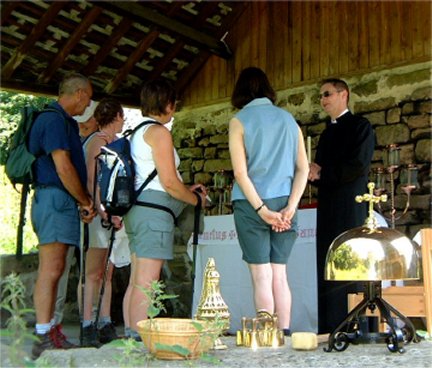
- (9.6km, 6 miles) Walk down stream to enter the wooded confines of Padley Gorge at a gate. The path picks its way down through the trees with beck tumbling over its rocky course far below. By a building (a disguised water pumping station) take a lesser path to the right. This picks its way down the hillside below Bolehill Wood, passing behind a home set in superb location with a stunning view down the Derwent Valley. The path comes down to a rough road next to a cattle grid. Just to the left, across the cattle grid is Padley Chapel and the ruins of the old manor - worthy of a visit.
- (12km, 7˝ miles) Cross back over the cattle grid and head down a track on the left - this crosses a bridge over the Sheffield/Manchester railway and enters the open meadows of the Derwent Valley. At a gap in the broken wall by the remains of a footpath sign, bear left to follow a faint line of a path diagonally to the bottom corner of a field, to join another path, which follows a field side down towards the river. Basically the route, often waymarked as the Derwent Way, is now just a matter of following the river back to Baslow.
- (14.4km, 9 miles) At the next road (B6521) turn right for a short distance, cross over and just before the bridge pick up the continuation of the path across a meadow. The path angles away from the river, crosses a stream, and enters woodland that is in the care of the National Trust. After about Ľ mile you leave the woods and cross a couple of fields, after which the path becomes paved and enclosed by walls. Continue along a lane in Froggatt passing the old bridge to join a path by the river. The path now keeps close company with Derwent for the next mile, save the crossing of the B6054 by the 'new' bridge. As you near Calver you must join the minor road, which is forced by the steepening valley side, to run close to the river.
- (16.4km, 10Ľ miles) At Calver turn right by the Bridge Inn to cross the river by means of the old road bridge. Cross the old road and follow a footpath, which passes under the new road bridge and along the side of housing estate. Soon the bustle of civilisation is behind you, with just the river, now on your left, for company. After a two fields, you enter a strip of woodland and the river meanders away to the left. The path keeps to the valley floor around the bottom of the hill to your right, before cutting across a meadow to a gateway and a lane leading into Bubnell. For the next Ľ mile the Derwent is again your companion, with a weir and a former mill on the opposite bank. Cross the old bridge into Baslow, walk past the church and cross this busy road with care. To get away from the traffic take the back lane up through the village past the school, turning down Eaton Hill to the road crossing opposite the car-park.
Along the Way
Padley Chapel - this is all that remains of the 14th century manor house of the Padley family, devout Roman Catholics. With the persecution of Catholics in the 16th century, two priests Nicholas Garlick and Robert Ludlam, had taken refuge at the manor, but were discovered and arrested on July 12th 1588. Just twelve days later they were hung, drawn, and quartered. The manor was eventually sold and fell into ruin. In 1933 the Catholic Nottingham Diocese purchased the site and converted the one remaining building into the chapel we see today. A pilgrimage his held each July to the chapel.
Arnold Underwood (July 2003)
|