|
|
NORTH YORKSHIRE MOORS
Battersby - Castleton
The Esk Valley Line is considered to be one of the hidden gems of the British railway network. It offers a succession of surprises and stunning views along its 36mile run to and from the traditional Yorkshire fishing port of Whitby. From Whitby, the line runs through the picturesque landscapes and countryside of the valley of the River Esk, passing through well-kept stations including Grosmont, where it connects with the North Yorkshire Moors Railway (NYMR).
The line serves a succession of small communities on its way through the North York Moors National Park to the isolated station of Battersby, on the edge of the moors. The train reverses here and continues to Middlesbrough.
Here we take the train from Castleton to Battersby and walk back
Fact File
|
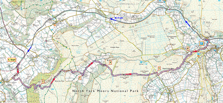
Distance
|
14.4km/9 miles |
|
Time
|
4 hours (walking)
|
|
Grade
|
*** (moderate)
|
|
Map
|
OS Explorer OL 26 (North York Moors West)
|
|
Start/Parking
|
Free parking for a few cars at Castleton Moor railway station
Catch a Middlesbrough-bound train from Castleton Moor (9.33am Mon-Fri, 9.27am Sats, or 11.07am Summer Sundays (until Sept 14th 2008) to Battersby Junction.
Walk starts from Batterby Junction Station
|
|
Terrain
|
Field & moorland paths, tracks & minor roads
|
|
Nearest Town
|
Guisborough
|
|
Refreshments
|
Pubs and café in Castleton
|
|
Toilets |
Castleton
|
|
Public Transport
|
Esk valley trains Middlesbrough – Whitby, bus services 25-28 Guisborough - Whitby (only 1 or 2 per day), also Moorsbus services from the surrounding area to Castleton (Easter – October).
|
|
Suitable for
|
strong walkers
|
|
Stiles
|
4
|

Route created using TrackLogs Digital Mapping
Image reproduced with kind permission of Ordnance Survey and Ordnance Survey of Northern Ireland.

- (Start – Battersby Junction station) Leave the platform and walk past the former railway cottages along the lane to the road and turn right. In about Ľ mile (400m) turn left along a lane, which leads to the buildings at Bank Foot. This is where the old Rosedale railway from Battersby began its climb up onto the moors – its path is now used as a forestry road to the foot of Ingleby Incline. However, our walk makes a direct assault on the escarpment by keeping to the stony track, which zig-zags up through the trees past disused quarries.
- (2.9km/1ľ miles)At the top of the steep climb this track swings round to head due south – here look for a faint path on the left heading east, across the moor. This brings you to another track – the Cleveland Way – on Battersby Moor. Go left along this track to its end at a gate onto the Baysdale road. Head down the road into the dale, passing Baysdale Farm.
(Note – due to diversions, footpaths in this area may not be as shown on older maps)
- (5.8km/3ľmiles)In the valley you arrive at the farm on the site of Baysdale Abbey. Here, follow the way-marks that route you round to the left of the buildings along a track by the beck. Follow this track for about ˝ mile until you reach a fork by some barns. Bear right to follow the track up to Shepherd’s House going left of the buildings, and climb steadily up through the trees onto the open moor.
- (7.4km/4˝miles)At the top, keep along the edge of the trees, following the track across the moor, to come above Great Hograh Beck. Here you zig-zag steeply down to a footbridge over the beck and up the other side. The path continues due east, with the occasional cairn, crossing Little Hograh Beck to reach a metalled lane. Go straight ahead to reach the Westerdale road.
- (10.2km/6˝miles)Here turn down right down the road and just before the gate/cattle-grid go left alongside the wall. Keep to the moor side of the wall – to join a right-of-way above the former farm at Dale View. Follow way-marks, which guide you alongside the wall for about ľ mile (1km). The path then descends steeply to a footbridge across a stream, actually the infant River Esk, and then follows the river to the road by Dibble Bridge.
- (12.8km/8miles)Walk up the hill to the crossroads and turn left. In about 300yds a footpath, right, will take you into Castleton village. Otherwise to return to the railway station, continue down the road and turn left to cross the bridge over the River Esk. (14.4km/9miles)

Along the Way
Castleton
The Parish Church has furniture by Robert Thompson (The Mouseman) of Kilburn, who carves a church mouse on all furniture produced by his workshop as a trademark.
Local folklore says that the village was named after a castle built in the vicinity on the banks of the River Esk by Robert de Brus.
Ironstone mining and smelting took place here until the mid 20th century, and people in the area can remember when a working quarry existed on top of the hill North of the river.
Arnold Underwood/HWC (June 2007)
|
