|
EAST YORKSHIRE - Beverley (Hull Bridge) - 17.5km (11miles)
'Beverley Circular'
A complete circuit of the East Riding county town of Beverley, by way of riverbank, canal-side, common land and farmland.
As featured in Country Walking Magazine October 2008
Fact File
|
Distance
|
17.5km/11miles (can be shortened by cutting through Beverley)
|
|
Terrain
|
Field paths, bridleways and riverbank
|
|
Time
|
5 hours
|
|
Stiles
|
10
|
|
Grading
|
*** Moderate
|
|
Suitable for
|
all û but care needed at road and rail crossings
|
|
Start/Parking
|
Hull Bridge Road, Tickton (near Crown & Anchor) TA 055417. Alternative starting points could be on Beverley Westwood (point 5) or near the Hayride (point 7) |
|
Nearest Town
|
Beverley
|
|
Refreshments
|
Crown & Anchor Inn at Hull Bridge (Start/Finish). Numerous pubs and cafes in Beverley and several other pubs on the route
|
|
Toilets |
none on the route
|
|
Public Transport
|
East Yorkshire 246 from Hull and Beverley passes close to Hull Bridge. Numerous other bus routes and Northern trains serve Beverley from the surrounding area.
|
|
Map
|
OS Explorer OL294 Kingston-upon-Hull and Beverley
|
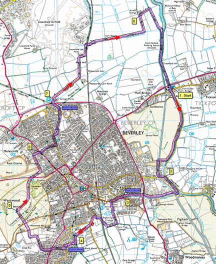

Route created using TrackLogs Digital Mapping
Image reproduced with kind permission of Ordnance Survey and Ordnance Survey of Northern Ireland.

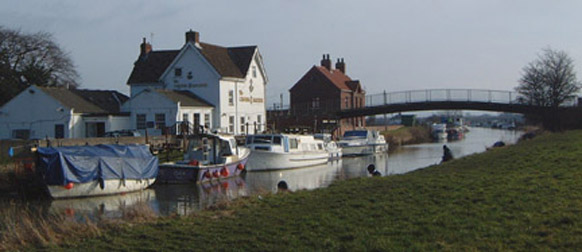
- (Start) From the Crown & Anchor cross the footbridge over the River Hull and go left through gates to head south along the river bank. To your right the flat expanse of Swine Moor stretches towards Beverley. As you follow the sweep of the river, look and listen for signs of wildlife û the blue flash of a kingfisher, the chatter of warblers and buntings in the reed beds. As you approach an industrial area you must leave the river bank and cut across to the corner where a stile accesses a footbridge of Barmston Drain. Walk alongside the drain to Grovehill Road. Here turn left and head towards the swing bridge, but do not cross. Bear right to rejoin the river bank alongside a large brick industrial building.
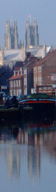
- (2.5km/1¢miles) Walk the river bank passing several moored vessels in various states of repair or disrepair! The path narrows and cuts through trees to come alongside Beverley Beck near the lock gates. The path goes round the perimeter of a boat yard before rejoining the beckside. This is particularly pleasant section, with overhanging trees reflecting in the still waters. After passing under a road bridge you enter an area of recent redevelopment. Gone are the old derelict warehouses and factories, being replaced by tasteful modern housing. Here is the mooring of the restored Humber barge, Syntan. Directly ahead, Beverley Minster stands proud over the scene.
- (4.2km/2¢miles) By the Foresters Arms you reach a road junction. Cross with care and walk towards the town. In about 400m, turn left into Spark Mill Lane (FP sign). Walk along this track with allotments on your left, Beverley Leisure centre to the right. Follow the track into open country, turn right at a T-junction and straight on at the next junction and round to a gated crossing of the railway. Cross with care, making sure gates are closed behind you, and follow the track to Long Lane. Turn left along this lane for about 200m and there take a right turn along Willow Lane. Continue to the end of the lane where a gate/stile brings you to the bottom of the Lincoln Way estate.
- (6.3km/4miles) Head left and then take the first footpath, right, up through the houses. Fork left a little way on and this will bring you to Lincoln Way, opposite the Lincoln Arms inn. Walk past the pub and then turn right onto a footpath, which takes you up to the busy Victoria Road. Cross with care and go left a short distance before turning up a path by a white cottage. This takes you round the perimeter of new housing and alongside the boundary of a chalk quarry. The path turns left up the side of the quarry to reach an open meadow. Turn right past an old pit to a gate that opens on to Beverley Westwood. Head straight across the common to Black Mill, where a bench and views across the Westwood make this an ideal place for a break.
- (8.6km/5¢miles) From the mill, head north across the common with Beverley Racecourse ahead. Occasional picnic benches provide alternative places for a lunch break. Drop down, skirting trees and bushes to the York Road. Cross with care and head right, following the perimeter of the race course round towards houses backing onto the Westwood. Go through a gate and walk along the bottom edge to a corner where a path between walls leads to Gallows Lane. Turn right down the lane to emerge on Molescroft Road.
- (10.3km/6¢miles) Cross and turn right and then left by a cemetery, into Bleach Yard. Walk down this lane past stables and between houses onto Manor Road. Turn left, cross over, then right into Scrubwood Lane. Go immediately left (Minster Way SP) and bear round to the right looking for concealed footpath between hedges on the left (Minster Way SP). Follow this path along the back of homes to reach more recent housing. Walk through to a mini-roundabout and cross over to approach the rear of the Hayride pub. Take the footpath left up and over the footbridge crossing Grange Way swinging right through a car park.
- (11.9km/7¢miles) Leave the car park and turn left follow the lane round to the right (ignore FP straight on). Keep to this lane as far as Leconfield Low Parks Farm. At the entrance turn right (Minster Way) along the field side to a stile in the corner, near the railway. Walk along field sides parallel to railway with Leconfield Army Driving School ahead left. At the second set of gates on the right (waymarked) go through and cross the railway with care. Make sure the gates are closed behind you. Now walk along a track over flat farmland, passing the ruined buildings at Carr House. Switch to the opposite side of the drain to reach a track left leading to Arram Grange.
- (15.3km/9¢miles) Turn right in front of the farm. Go through a gate and down to a bridge over Barmston drain. Across the bridge turn right along the field parallel to the drain. As you approach a fence turn up the river bank which has been converging from the left. Cross a stile and follow the river bank back to Hull Bridge. Note a new plantation and nature reserve on the right and please mind your heads as you pass under the rather low road bridge.
(17.5km/11miles)
Along the Way
Set in the side of the footbridge over the River Hull is a stone from the original Hull Bridge stating that Toll charge is 6d.
Syntan, one of last remaining Sheffield size motor barges, belonged to the R Hodgson and Son Tannery. It was a regular sight on the River Hull as it supplied Beverley with the vital materials for the tanning industry.
Most of these barges no longer exist and the few that survive have been turned into pleasure craft. Syntan would have gone the same way had it not been for a group of enthusiasts who restored it to its former glory, placing her on the towns re-vitalised Beckside.
Arnold Underwood with Hornsea Walking Club (Jan 2007)
|