|
NORTH YORK MOORS - Bilsdale & Raisdale
'Close Encounters'
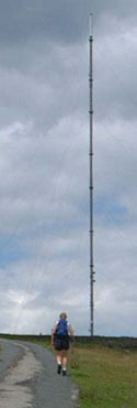
Bilsdale is also well known for its TV Transmitter Mast. Due to the fact it is built on Bilsdale West Moor at 370m (1200ft) above sea level the setting is quite spectacular and the overall aerial height/altitude is 685m (2260ft). This is one of the highest in the UK.
On this walk, a steady climb brings you right up to the mast, after which you can stride out along the ridge with wide-ranging views.
Fact File
|
Distance
|
16.2km (10˝ miles)
|
|
Time
|
5 hours
|
|
Map
|
OS Explorer OL26 North York Moors West
|
|
Start/Parking
|
Chop Gate (Village Hall) SE 558 995
|
|
Terrain
|
Field and moorland paths, bridleways, and minor roads, with a steep climb onto Bilsdale West Moor
|
|
Grading
|
*** moderate/strenuous
|
|
nearest Town
|
Stokesley
|
|
Refreshments
|
The Buck Inn at Chop Gate
|
|
Toilets |
Chop Gate village hall
|
|
Public Transport
|
Moorsbus (Suns & Bank Hols, Easter - October and weekdays, July - Aug)
Visit the Moorsbus website for full details
|
|
Suitable for
|
all
|
|
Stiles
|
6
|
Route created using TrackLogs Digital MappingImage reproduced with kind permission of Ordnance Survey and Ordnance Survey of Northern Ireland.

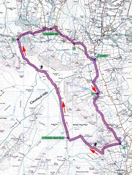
- (Start) Leave the car park at the far end, by a bridge over the river. Immediately cross a stile on the left into a field. Walk along the bottom edge of the field, close to the River Seph – it can be quite wet underfoot and muddy where cattle have been. Persevere along by the river, crossing a couple of stiles, and eventually you climb away onto firmer ground. Walk along the edge of two fields and through a gate to Orterleys Farm. Go through the farm turning left behind barns to pick up a bridleway heading south. At Low Crookleith Farm walk down by a wall to join the farm road near a cattle grid.
- (1.8km, 1Ľmiles) Just below (east of) the cattle grid a footpath sign points the way across a beck. The next section is a bit tricky, and devoid of waymarks. Turn up the field alongside a wall towards High Crookleith. Continue up a track, bearing left through a gateway. As you follow the track through the next field be prepared to head right across to a gate in the wall. Through this you rejoin the tractor track and follow it along the valley side for about ˝mile to Beacon Guest. Go past the house onto the driveway. Do not go down the drive but fork right through a gate to maintain the contour down to Stable Holme
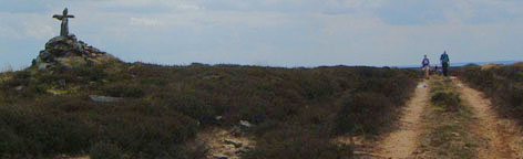
- (4km, 2ľ miles) Turn right up the road towards Stingamires. This is the start of a 250m (800ft) climb up onto Bilsdale West Moor. From Stingamires the road becomes a private access to the Bilsdale TV Transmitter. The map shows a path following this road, on and off, up the hillside, but no one seems to object to walkers using the road all the way to the top. It is a stiff pull up round a hairpin bend with views extending up and down the valley – good excuses to pause for breath! The gradient eases and the road heads straight for the mast. This stands at about 370m (1200ft) above sea level and towers to about another 300m (1000ft) above you. Just before the compound at the foot of the mast, bear left to follow faint wheel-tracks across the moor. Initially heading west, these tracks then swing due north, to merge with the main track heading along the watershed. It is exposed up here with views west across the Vale of York to the Pennines. A sheltered hollow below a prominent cairn with a cross, provides some protection if you wish to stop for lunch.
- (6.8km, 4ľ miles) Continue north along the obvious track over Whether Hill to Green Howe at 400m (1300ft) above sea level. From Whether Hill a direct descent down Trennent Bank leads you straight back to Chop Gate. After Green Howe the track swing west to meet another track at a T-junction. Ahead the valley of Scugdale opens out. Looking back, Bilsdale Mast appears to be too far over to the right – this illusion resulting from track you have followed having gradually swung to the west. At the junction turn right and follow the track down across Barkers Ridge, between Scugdale and Raisdale. Across to the right, Roseberry Topping puts in a brief appearance through a gap in the hills. Ahead can be seen the gliding club on Carlton Bank. At a crossing of tracks, below Barkers Crags, turn right down into Raisdale.
- (11km, 7ľmiles) Keep to this ancient green lane down hill, and as indicated by waymarks keep to the left of a wall as you descend. Eventually through a gate, the lane becomes enclosed by walls and wet under foot as it drops down to Raisdale Mill. Ignore paths to the right and continue down into the hamlet at Raisdale Mill. The restored cottages here are mostly holiday homes. Turn left and walk past the houses and round and up to the Raisdale Road, and here bear right to walk downhill.
- (13km/ 8˝miles) This narrow road is quite popular at weekends with motorists heading to and from Carlton Bank. Walking this road can be tedious, so although it provides an easy 1˝mile return to Chop Gate, it is possible to avoid the tarmac for much of the way. At the first bend a footpath strikes off up the hillside on the left to emerge on a lane above Stone Intake. Turn right and walk past the buildings to a farm track at a gate on the left. Follow this track as it contours along the hillside towards more farm buildings. Here the path drops down to a stile into the field and you walk along the top of the field, where they maybe a bull with the cows and calves, below the farm, to a gate at the far end. Maintain direction across the next field, and into the next. Here the hillside gets overgrown with bracken in summer. Continue forward until clear of the dense bracken then bear right down to a stile and on down to a farm track. Walk along this track back to the Raisdale Road.
- (14.5km/ 9˝ miles) Just past the farm gate, a footpath sign on the left indicates another loop across fields, where it turns to follow a stream back towards a bridge on the road. It is however only Ľmile down the road to this bridge. Whether you take the field route or the road, at this bridge cross a stile to follow the stream, the infant River Seph, back to the car park at Chop Gate village hall. The going can be wet under foot along the bottom of the fields. (16.2km/10˝miles)
Along the Way
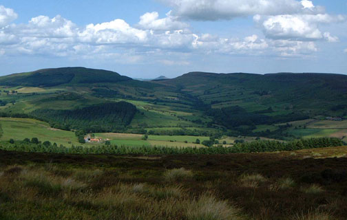
Bilsdale lies between the viewpoints at the tops of Clay Bank to the North and Newgate Bank to the South, through farmland with drystone walls, native woodland, and open moors on the hills above, with a few small conifer plantations. The B1257 Stokesley to Helmsley road threads the length of the dale – a favourite run for bikers.
Chop Gate is the Dale’s main centre of population, with its school, chapel, The Buck Inn pub, cricket pitch and village hall.
Further south, St John’s Church stands close to the road, and the River Seph meanders largely unseen, except where it passes beside the tiny hamlet of Fangdale Beck.
Arnold Underwood with Leven Walking Club (July 2004)
|