|
EAST YORKSHIRE - Bishop Wilton (8 miles)
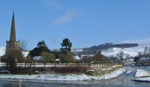
Bishop Wilton village shelters in the Vale of York below the western edge of the Yorkshire Wolds. This winter route loops round flat farming country to Yapham before climbing up on to the Wolds to visit Great Givendale with its tiny Church dedicated to St Elthelburga. A steep descent on the Minster Way brings you back to Bishop Wilton.
Fact File
|
Distance
|
13km (8miles)
|
|
Time
|
4 hours
|
|
Map
|
OS Explorer 294 (Market Weighton & Yorkshire Wolds Central)
|
|
Start/Parking
|
Park tidily by the green in Bishop Wilton. Grid Ref: SE 797550
|
|
Terrain
|
Field paths, bridleways & minor roads. Can be muddy in places
|
Grade
|
** (fairly easy)
|
|
nearest Town
|
Pocklington
|
|
Refreshments
|
Fleece Inn, Bishop Wilton
|
|
Toilets |
none
|
|
Public Transport
|
Two buses a day on service 747 (Pocklington - York) (Not Sundays)
|
|
Suitable for
|
for everyone.
|
|
Stiles
|
10
|
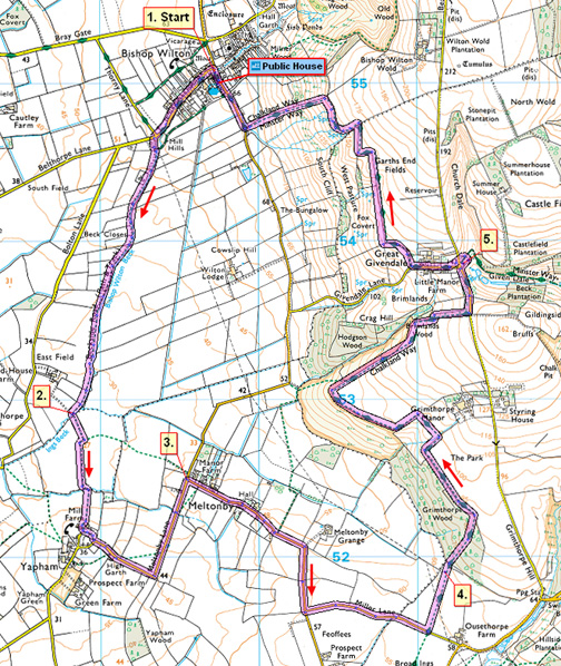

Route created using TrackLogs Digital Mapping
Image reproduced with kind permission of Ordnance Survey and Ordnance Survey of Northern Ireland.

- (Start) Set off due west along the lane on the right-hand side of the beck. At the edge of the village, take a track left (FP sign in hedge) past a water treatment works. This pleasant green lane follows the beck for about 2km. As you approach Eastfield Farm cross a stile, then another, after which the path turns left over the beck and heads towards Yapham.
- (2.4km, 1˝ miles) Keep round the field sides until, as waymarked, the path turns right and heads straight up a field towards Mill Farm in Yapham. Go through a metal gate into the farm yard, which in part is now given over to a new housing development. Turn left to follow footpath between new homes to the access road and turn right to a T-junction, Go left along the road away from Yapham. A footpath cuts left across a field bypassing a bend in the road. Rejoin the road and walk down to Meltonby.
- (4.3km, 2˝ miles) Turn right opposite a bus shelter and follow the minor road towards Pocklington. After rounding a bend turn left along a narrow lane (no signpost). In a further 800m at a FP sign, go left over a stile into a field. Walk straight across this large field, passing just left of electricity poles, towards a wood. There may well be cattle, with a bull in this field. Beyond a few trees a stile marks the entrance to Grimthorpe Wood.
- (7.0km, 4Ľ miles) A clear path climbs steadily up through the woods, then levels out and twists and turns through a boggy area. Several waymark posts guide you through and out into open farmland. Turn left to follow the edge of the wood along the bottom of the field and round the corner. Go down a bank (can be slippery) and across a footbridge and stile onto an enclosed path. At the end of this section follow the bottom side of the next field round and up towards more woodland. The path goes left into the wood and heads up through the trees to reach the Givendale road. Turn left down the road to Great Givendale.
- (10.5km, 6˝ miles) After visiting St. Ethelburga’s Church, return to the road and walk through the hamlet past Manor Farm towards Bishop Wilton. Turn right along a track (FP Minster Way). Go through a gate and walk along the side of a field by a newly planted hedge. There are extensive views left across the Vale of York. Keep left at a corner and follow the fence down to stile. Drop down a slippery bank to another stile by a gate and then walk along the top of the hillside. At the opposite corner of the field you must turn left and pick you way down hill. It can be quite wet, with springs issuing from the hillside. Go through a gate at the bottom and turn right along the road back to Bishop Wilton (8 miles)
Along the Way
Bishop Wilton
An area on the eastern edge of the village (Hall Garth) is known to have been the site of a Palace for the Archbishops of York during the 13th and 14th centuries. Earthworks of the former moat and fishponds are still visible.
St Edith's church was one of many in the area restored by the Sykes family of Sledmere. St Edith's is described as an example of 'the sheer opulence of Victorian ornament inside a medieval church'.
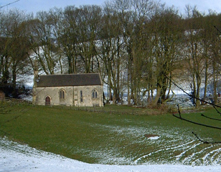
Great Givendale
St Ethelburga's church sits in a delightful location overlooking the wildlife ponds created in Given Dale. The church was rebuilt in 1849 but dates back to the 12th century and retains a Norman chancel arch.
Arnold Underwood (Feb 2005)
|