
|
NORTH YORKSHIRE - Thornton-le-Dale - 16.8km (10˝miles)
'Into Dalby Forest'
Dalby Forest is located on the southern slopes of the North York Moors National park. It is maintained by the Forestry Commission. The southern part of the forest is divided by a number of valleys creating a 'Rigg and Dale' landscape whilst to the north the forest sits on the upland plateau. Although the forest comprises mostly of pines and spruces there are many broadleaf trees such as oak, beech, ash, alder and hazel both in the valleys and on the 'Riggs'. It is also home to many species of wildlife such as badgers, roe deer and nightjars.
This walk enters Dalby Forest through the ‘back door’ by way of field & woodland paths and farm tracks. Once away from Thornton Dale, and past the Shooting Club, all should be peaceful and you are unlikely to meet anyone until you near the Dalby Forest Centre where you must keep a look-out for cyclists of all ages. The hustle and bustle is soon left behind as you return down the dale past the fish farm and the sleepy hamlet of Ellerburn.
Fact File
|
Distance
|
16.8km (10˝miles)
|
|
Terrain
|
Field paths, forest tracks & minor roads. Can be muddy in places.
|
|
Time
|
4˝ hours
|
|
Stiles
|
6
|
|
Grading
|
*** Moderate
|
|
Suitable for
|
all – but care needed on the Forest Drive (traffic)
|
|
Start/Parking
|
Thornton-le-Dale |
|
Nearest Town
|
Pickering
|
|
Refreshments
|
Thornton-le-Dale (Pubs & tearooms), Low Dalby Courtyard (Purple Mountain Café)
|
|
Toilets |
Thornton-le-Dale and Low Dalby
|
|
Public Transport
|
Thornton-le-Dale is served by Yorkshire Coastliner 840/2, Scarborough & District 128 (daily) and Moorsbus (Summer Sundays & Bank Holidays)
|
|
Map
|
OS Explorer OL27 North York Moors (East)
|
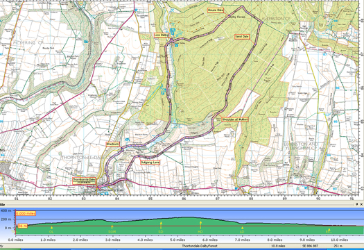

Route created using TrackLogs Digital Mapping
Image reproduced with kind permission of Ordnance Survey and Ordnance Survey of Northern Ireland.

- (Start) Exit car park through the ‘hole in the wall’ passing toilets and pond to cross a footbridge over a beck. Walk back along pavement by the beck and then cross main road and continue past Almshouses in direction of church. Continue along pavement over beck again to the church on its hill overlooking the village. Walk up Church Lane behind church. Ignore footpath left and continue to the end of the lane where you turn left.
- (1.2km/ľ mile) Walk up this lane (which may carry traffic to and from a landfill site) bearing right at a junction. This lane is named Outgang Lane on the map and it is followed for about 2km onto a ridge overlooking the valley of Thornton Dale. Again, ignore other paths and tracks that may branch off and continue along the main track. You may be alarmed by the sound of gunfire, red flags, and warning signs but keep to the main track and you will be ok, eventually passing a deep quarry on your right where you can look down on the activities of the gun club. The sides of the quarry seem to echo and amplify the sounds of gunfire. The track continues past woodland on your left with open farmland right, until it reaches a barrier at the entrance to Dalby Forest.
- (4.4km/2ľ miles) Continue past the barrier and take the path left, to join a forest track. Pass another barrier and head downhill to meet another track and there bear right. Soon you come to 3-way split – take the track on left (waymarked) leading into Sand Dale. It is now a gradual upward trend for about 1km through the forest, but the trees are set back so it is not at all claustrophobic. Ignore any side paths, which are likely to be mountain-bike tracks, and eventually the ground levels out at an open area – a pleasant spot for a break.
- (7.6km/4ľ miles) About 100m beyond the clearing, the track meets a forest road. Turn left here and walk along the road, crossing the heads of several dales (all named). Follow the road as it swings left – ignore waymark straight ahead – down House Dale towards Low Dalby. The only traffic is likely to be cyclists. This road is bordered by some tall conifers. Pass a Forestry Commission depot, then a barrier, to reach South Dalby village. Turn right to the Courtyard for the Blue Mountain café, toilets etc. The new Dalby Forest Visitor Centre is some 200m further, by the main car park.
- (11.2km/7 miles) From the courtyard cut through to the road and turn left to walk up the Dalby Forest Drive – take care - this road can be busy with traffic. About 400m up the road, bear left onto Dalby Beck lane. Follow this lane past a few cottages and barns into woodland. This is part of a popular short circular walk from the Centre. In the woods the circular walk drops down to the left but our route continues straight ahead as a grassy path. At the end of the woodland, climb a stile into farmland. The route follows the bottom of the grassy slopes of Thornton Dale past Paper Mill Pond and then as an enclosed path past the trout farm to join the lane into the hamlet of Ellerburn. After passing two cottages you reach the tiny, historic church of St Hilda.
- (15.2km/9˝ miles) Opposite the church walk across the bridge over Thornton Beck towards Low Farm. Turn right on a muddy path between barn and beck to a stile. Over the stile it is now a simple matter of following the beckside path back to Thornton-le-Dale. As you approach the former mill, now converted to apartments, the path swings left with views back to a water cascade. At the road, go left and walk alongside the beck then turn right over a footbridge opposite Beck Hall. Continue between the beck and cottages to the main road through Thornton-le-Dale. Turn right, cross the road opposite the Almshouses and make your way back to the car park (16.8km/10˝miles)
Along the Way
Numerous mills were operated in the Thornton & Ellerburn area for various purposes; fulling, paper-making, down to the Burgess family milling flour.
The main Thornton manor passed into the hands of Richard, first Viscount Lumley, through his marriage to Elizabeth Sandys, a granddaughter of the forth Lord Latimer. When her son died in 1656 she founded a charity for the building of alms houses & a grammar school at Thornton
Dalby Forest is used for recreation as well as timber production. There are hiking trails and mountain bike trails, a 'forest drive' throughout the forest and a Go Ape centre. A toll is charged to enter the forest by car, although parking is free. The main visitor centre has a café and shop, a bike shop and various craft workshops.
 Arnold Underwood (April 2012)
|
