|
NORTH YORK MOORS - Danby
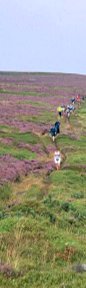
'FRYUP TIME!'
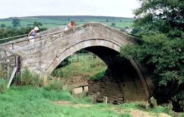
Late summer and the North York Moors are purple with the blooming heather. This walk takes you onto Danby Rigg before dropping down to cross the head of Little Fryupdale. Then along the ridge between Little and Great Fryup Dale before descending to Duck Bridge, and returning to Danby. Duck Bridge is a 14th Century pack-horse bridge over the River Esk. The name has nothing to do with ducks, but is named after George Duck who restored the bridge in the 18th Century.
Fact File
|
Distance
|
13km (8 miles)
|
|
Time
|
allow up to 5 hours
|
|
Map
|
OS Explorer Outdoor Leisure 27 North York Moors (East)
|
|
Start/Parking
|
Danby Moors Centre
|
|
Terrain
|
Field paths, tracks and moorland
|
|
nearest Town
|
Guisborough
|
|
Refreshments
|
Pub in Danby village: Moors Centre tea room
|
|
Toilets |
Moors Centre
|
|
Public Transport
|
Moorsbus in summer months. Trains on Esk Valley line (Middlesbrough - Whitby)
|
|
Suitable for
|
all
|
|
Stiles
|
8
|
- (Start) Start: Cross the road and take the footpath through the gate to the left of the Moors Centre entrance. This well-used path crosses a footbridge over the Esk and skirts a muddy pond (with cattle hereabouts) and climbs up to cross the railway line (take care here). Cross the next field to a stile and turn right along the road.
- (1km, ľ mile) About 200yds along the road, past a couple of houses, a half hidden footpath sign on the left points the way along a field side. At the corner do not cross a stile on the left but turn right alongside the hedge to another stile in the next corner. Cross and walk with the hedge on your left over the next field, cutting the corner to reach a ladder stile. Head across the next field towards a cottage (Low Coombs) swinging left in front of it. Cross its driveway and head straight up the hillside to again encounter the driveway, which has zig-zagged up the hillside. Turn right and continue up the driveway to a road.
- (2.4km, 1˝ miles) Cross straight over to a track climbing onto the moor. Ignore cross tracks and continue forward until you intersect the main track heading up the rigg from Ainthorpe. Turn left and you soon reach a gate on to the moor. Follow this rough track as it climbs steadily onto Ainthorpe Rigg. A lone standing stone and the remains of a stone circle, mark the end of the climb. Pause to look back over the Esk Valley and rolling moorland, with the distinctive profile of Roseberry Topping in the distance.
- (4.8km, 3 miles) The path continues the edge of the moorland, but do not descend to the road. (This is a useful escape if conditions are not good). Follow a narrow path that keeps to the edge of Danby Rigg for about a mile, until it joins the road as it climbs out of the valley. Turn right up the road and at the top of the hill at a bridleway sign turn left down a track, which by late summer may be well overgrown with bracken. After fighting your way through, you reach a gate opening into hillside pastures. Skirt round the right of Round Hill, through a gateway and then diagonally across to a gate onto a road by some cottages. Turn left down the road.
- (8.5km, 5˝ miles) A little way down the hill, turn right a long a walled green lane (bridleway). Follow this round to the right towards the ridge. Turn left and follow the track as it climbs steadily up onto the ridge. The ground levels out and the track swings away from the edge then back to reach a gate in a wall. Do not continue forward, but turn left and go through another gate. From there, a path descends the hillside quite steeply, becoming overgrown with bracken. At the bottom, cross a stile and continue straight down across rough ground to a bridleway and turn right through a gate.
- (13km, 8 miles) Follow the bridleway keeping alongside a wall with the wooded hillside to your right. At a sign post drop down to a gate to the left of Crag Farm. Walk along the farm road, crossing the Esk to reach the Danby road. Turn left along the road (take care - it can be busy). After a double bend, bear left onto the minor road towards a ford and the packhorse bridge (Duck Bridge) re-crossing the Esk. Note the ruins of Danby Castle up to the left. Turn right and walk along the road towards Ainthorpe. Cross a stile on your right and retrace your steps across railway and river to the Moors Centre
Along the Way
Near Danby, Duck Bridge was originally built to provide access to Danby Castle. The castle site is now part occupied by a farm, but access to the ruins can be made by enquiring at the farm. Danby Rigg is dotted with evidence of Bronze Age settlement. By the standing stone, two urn burials dating from 1000BC have been excavated.
Arnold Underwood (Aug 2002)
|