

|
PEAK DISTRICT - White Peak Area
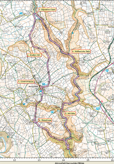
Seven Dales from Alstonefield - 15.2km (9˝ miles)
We tend to think of the Peak District as being in Derbyshire, but much of this walk is actually in Staffordshire. The River Dove marks the county boundary.
The walk includes a classic section of Dovedale, but with the added feature of a climb to the top of Gratton Hill (Access Land) for a panoramic view of the limestone landscape of the White Peak.
The seven dales are: Narrowdale, Beresford Dale, Wolfescote Dale, Milldale, Dovedale, Hall Dale, and Hopedale.
Fact File
|
Distance
|
15.2km (9˝ miles)
|
|
Time
|
4˝ hours
|
|
Map
|
OS Explorer OL1 White Peak
|
|
Start/Parking
|
Alstonefield (car park)
|
|
Terrain
|
Undulating farmland and riverside paths and tracks
|
|
Grading
|
****
|
|
nearest Town
|
Ashbourne
|
|
Refreshments
|
Pub (The George) at Alstonefield, tea kiosk at Milldale, farm shop at Stanhope
|
|
Toilets |
Alstonefield and Milldale
|
|
Public Transport
|
405 Leek circular (2 per day Mon-Fri); 442A Ashbourne-Buxton (1 each way Sun & Bank Hols); 443A Ashbourne (1 each way Thurs & Sat); 449 Bakewell (1 each way Mon only)
|
|
Stiles
|
6
|

Route created using TrackLogs Digital Mapping
Image reproduced with kind permission of Ordnance Survey and Ordnance Survey of Northern Ireland.

- (Start) From the car park, walk into the village and at the green in front of the George bear left along Lode Lane towards Milldale. In about 200m, turn left along an enclosed ‘green lane’ (footpath sign). Ignore all other signs and keep between the walls to reach the lane end at the open pastures of Gratton Hill. Cross the cattle grid and head straight up the hill to its summit at 362m.
- (1.6km/1 mile) Here there is a panoramic view across the White Peak landscape. Now pick your way down the steeper north-west side of the hill into Narrowdale. As the hill is grazed by cattle it can be rough underfoot and muddy after rain. Go through a gate and follow a farm track through several gates to reach a junction of a surfaced cycle path. Continue straight ahead to reach Beresford Lane and turn right to reach a footbridge (and stepping-stones) across the River Dove.
- (4.0km/2˝miles) Across the river turn right along a path across a meadow. Route finding is now easy as you follow the well-trodden path down the by the River Dove. Although the valley is generally referred to as Dovdale, different stretches are accorded different names – this first section is Beresford Dale. A little further you enter Wolfescote Dale, and then Biggin Dale joins from the left. Continue downstream passing many small weirs that are feature of this river. These weirs were built to create ideal conditions for trout and trout fishing (made popular by Isaak Walton and Charles Cotton in the 17th Century)
- (6.0km/3ľmiles) Continuing down the limestone gorge you reach a pair of cottages and a bridge carrying the minor road to Milldale and Alstonefield. Cross the bridge and walk along the pavement into Milldale. Here there are toilets and a small refreshment kiosk. In the river can be seen remnants of a sluice and millstone from the days when there was a water-mill here. The stone pack-horse bridge is known as Viator’s Bridge after a character in Izaak Walton’s book, The Compleat Angler.
- (9.6km/6miles) Cross the bridge and continue downstream. The path will become busier now with walkers heading up the valley from the large car park near Ilam. The path climbs above the river to pass a large slab of rock. Eventually you reach a footbridge beneath the towering Ilam Rock. Cross the bridge and head upstream until the path swings left into Hall Dale. It is a long slog, initially quite steep up this dale until the terrain levels out on the limestone upland, criss-crossed with stone walls. The field path meets a farm track where you turn left into hamlet of Stanhope.
- (13.5km/8˝miles) Turn right in front of the hotel along another lane passing a farm and a farm shop that may be serving teas. As the enclosed path begins to descend, Alsonefield church tower can be spotted among the trees in the distance. Alas before reaching the church there is one final descent into Hopedale where the road is crossed to the right of a cottage, followed by a steep climb up the other side. A couple of fields are crossed and then you are back in Alstonefield.(15.2km/9˝miles)
Along the Way
The River Dove has many literary associations the most famous of whom is perhaps Izaak Walton, best known for his instructive book `The Complete Angler` or `The Contemplative Mans Recreation`. It remains the authoritive work on fly fishing. Another literary figure was Charles Cotton who in 1681 produced a laudatory poem called `The Wonders of the Peak`. These two men gave Dovedale its initial reputation which has encouraged generations of visitors to seek out the idyllic enchantment that Dovedale can provide, even to this day
Milldale used to be a bustling and busy hamlet with a Camomile mill but that closed in the late 1870’s. The remaining mill buildings have been converted into the National Trust information barn. The ancient packhorse bridge is the most famous of all in the Peak District and is known as the Viator’s Bridge. It was made famous in the English classic ‘The Compleat Angler’ by Izaak Walton.

Arnold Underwood with Leven Walking Club (May 2010)
|
