
|
EAST YORKSHIRE - Driffield Canal
Featured in Country Walking Magazine, October 2002
A Waterside Walk
Take a leisurely Summer stroll by river and canal from Driffield, the Capital of the Yorkshire Wolds.
Keep your eyes peeled to spot the variety of bird life on and by the canal, and on Nafferton Mere, and trout idling against the current in the clear waters of Wansford Beck.
Fact File
|
Distance
|
12km/7Ẅ miles
|
|
Time
|
4 hours
|
|
Map
|
OS Explorer 295 (Bridlington & Driffield)
|
|
Start/Parking
|
Riverhead, Driffield. Grid Ref. TA 028 571
|
|
Terrain
|
Field paths, riverbank & minor roads.
|
Grade
|
** (easy)
|
|
nearest Town
|
Driffield
|
|
Refreshments
|
Pubs in Driffield, Wansford and Nafferton, and the Riverhead Cafe in Driffield
|
|
Toilets |
in Driffield town centre
|
|
Public Transport
|
Driffield and Nafferton are served by East Yorkshire Buses from Hull, Scarborough & York, and by trains between Hull and Scarborough, plus other local bus services (irregular)
|
|
Suitable for
|
for everyone.Take care walking along the canal bank next to the B1249 into Wansford
|
|
Stiles
|
6
|
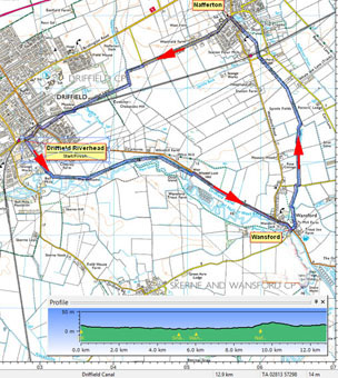

Route created using TrackLogs Digital Mapping
Image reproduced with kind permission of Ordnance Survey and Ordnance Survey of Northern Ireland.

- (Start) Walk away from Riverhead beside the canal to find a public footpath sign by the wrought-iron gates to a private drive. The footpath continues along the drive past the lock-side cottages, becoming a gravel path and finally a grassy track between tall hedges. This ends at a gate (waymark) opening into riverside meadows. Continue through another gate with the disused canal on your left and the meandering River Hull over to the right. The path keeps close to the canal for about a mile (1.5km), whilst the river twists and turns through the meadows.
- (1.2km/ẅ mile) If you are expecting to come to a footbridge over the river, as shown on OS maps, you will be disappointed. Apparently the bridge collapsed about 25years ago and although there has been talk of reinstating it, nothing has materialised. Therefore you must continue along the canal bank to a gate, which leads to a narrow path close to the water. Cross a 3-plank footbridge over a sluice serving a trout farm, to arrive at a bridge over the restored Whin Hill lock by the main B1249 road.
- (2.4km /1Ẅ miles) From here, the Driffield Canal Society has cleared a path along the canal bank, thus avoiding nearly 1.5km (1 mile) of road walking. There are occasional benches by the path, and it's worth sitting quietly for a while and you may get a glimpse of a kingfisher. As you continue the path becomes confined to a narrow bank between the road and the canal so take care, particularly if the path gets overgrown in the summer months. You arrive at Wansford by the lock gates, where seats provide a convenient spot for a break. Then continue on a narrow path under trees by the canal as far as the Skerne road bridge. (The Trout Inn is a short distance further along the B1249, but may not be open during the daytime).
- (3.9km/2Ẅ miles) Opposite the bridge, cross the road into Chapel Lane (footpath sign) and walk alongside the beck towards the former mill. Walk along the driveway, then left of the buildings, and over a footbridge. Turn to follow the beck towards Nafferton. After a few twists and turns, the beck maintains a straight course to a minor road. Her the path crosses to the opposite bank. Watch out for trout in the stream and, if you are lucky, the blue flash of a kingfisher.
- (6.7km/4Ẅ miles) After about 2.5km (1Ẅ miles) walking by the beck, you cross another minor road then the railway line near Nafferton station. The path turns half left across a paddock to arrive at the roadside in Nafferton. Continue forward towards the church, pausing to admire the lake the Mere which, in an area of quite dense housing, comes as something of a surprise. There are pubs and shops in Nafferton. Turn left at the church and walk out of the village along the road towards Driffield.
- (8.8km/6 miles) The road makes a right turn about 1km (ẅ mile) out of Nafferton, but a footpath continues straight on, past a brick barn. The path turns left to follow the field side, then right along a farm track. This passes the edge of a wooded area, and converges with the railway line. Cross the railway with care and continue along the lane through a new housing development on the outskirts of Driffield. At the main road turn right, then left immediately before the railway crossing to return to Riverhead.(12km/7Ẅ miles)

Along the Way
Driffield has been a market here for centuries, being the centre serving the fertile farmland of East Yorkshire. Several corn mills were established in the town as trade flourished with the opening of the canal and then the railway. Today one mill remains, with the others demolished or converted to flats and other uses. Two 19th century cranes are preserved alongside the canal at Riverhead. The Driffield Canal Society has ambitious plans to reopen the canal from Brigham to Riverhead, allowing craft once more to navigate from Hull to Driffield.
All Saints Church dates from the 12th century and is said to have one of the tallest towers of any church in the old county of Yorkshire.
The River Hull (also known as West Beck) rises near Driffield, and along with its other tributaries, provides some of the best trout fishing in the country.
The river and the canal provide a haven for waterfowl. In winter months a variety of ducks and geese can be seen, and cormorants move inland from the coast. Spring sees families of ducks, geese, coot and moorhen on the canal. Reed-buntings can be heard but rarely seen, and the blue flash of a kingfisher can reward the patient observer.
Arnold Underwood & Suzie Watson (Updated June 2015)
|
