
|
EAST YORKSHIRE – Driffield 14.4km (9 miles)
Riverside Ramble
A variation on the usual walk from Driffield, which avoids a dangerous section of road walking by keeping to quiet lanes and bridleways via the village of Skerne.
Keep your eyes peeled to spot the variety of bird life on and by the river, and on Nafferton Mere, and particularly for kingfishers along Nafferton Beck.
As featured in Country Walking magazine - Nov 2009
Fact File
|
Distance
|
14.4km/9miles
|
|
Terrain
|
Minor roads, field paths and bridleways
|
|
Time
|
4˝ hours
|
|
Stiles
|
5
|
|
Grading
|
** Easy
|
|
Suitable for
|
all – but take care along country roads
|
|
Start/Parking
|
Driffield Riverhead. Grid Ref. TA 028 572 |
|
Nearest Town
|
Driffield
|
|
Refreshments
|
Pubs in Driffield and Nafferton, and the Riverhead Cafe in Driffield
|
|
Toilets |
Driffield
|
|
Public Transport
|
Driffield is served by East Yorkshire Buses from Hull, Scarborough & York, and by trains between Hull and Scarborough
|
|
Map
|
OS Explorer 295 (Bridlington, Driffield & Hornsea)
|
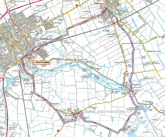

Route created using TrackLogs Digital Mapping
Image reproduced with kind permission of Ordnance Survey and Ordnance Survey of Northern Ireland.

- (Start) From the riverhead, head back into town and turn left over the level crossing at Driffield station. Walk along the pavement and fork left onto Skerne Road, re-crossing the railway. Initially this road serves Driffield’s industrial area, but once past this it becomes a fairly quiet country lane to the village of Skerne. The map shows an option to leave the tarmac but there was no sign of this field path, so keep along the road almost as far as Skerne. At a bend under some trees, a bridleway cuts right. Follow this to another road and turn left into the village. Skerne is a picturesque little village, just off the beaten track, which probably explains why its pub has been closed for several years
- (4.0km/2˝miles) Turn right through the village past empty pub, looking now very much neglected. Just out of the village turn right along a lane to Copper Hall Farm. The lane swings round to the farm beyond which our route continues as bridleway across fields. The first field can be very muddy, being churned up by horses, but as added interest behind the tall fence on the right is herd of deer. After the tedious field crossing you reach the bank of a drainage channel near to the River Hull. From now on keep a good lookout for a variety of birdlife. The river bank is followed to the brick road bridge at Wansford. Turn right to cross the bridge and in a short distance cross another over the Driffield Canal.
- (8.0km/5 miles) Opposite the canal bridge, cross the road into Chapel Lane and walk round by the beck towards the former mill. Go through gates to the left of the restored buildings, over a footbridge and turn to follow the beck towards Nafferton. At a road, the path crosses to the opposite bank. Watch out for trout and, if you are lucky, the blue flash of a kingfisher as you continue alongside the beck. Cross a minor road then the railway line after which the path turns half left away from the beck over a paddock to reach the roadside in Nafferton. Continue towards the church, pausing to admire the Mere – which, in an area of quite dense housing, comes as something of a surprise.
- (12.4km/7 miles) Turn left at the church and walk out of the village along the road towards Driffield. The road makes a right turn about 1km (˝ mile) out of Nafferton, but a footpath continues straight on, past a brick barn. The path turns left to follow the field side, then right over a ditch. This path passes the edge of a wooded area, and converges with the railway line. Cross the railway with care and continue along the lane alongside housing on the outskirts of Driffield. At the main road turn right, then left immediately before the railway crossing to return to Riverhead. (14.4km/9miles)
Along the Way
Driffield

Driffield has been a market here for centuries, being the centre serving the fertile farmland of East Yorkshire. Today one mill remains, with the others demolished or converted to flats and other uses. Two 19th century cranes are preserved alongside the canal at Riverhead.
The Driffield Canal Society has ambitious plans to reopen the canal from Brigham to Riverhead, allowing craft once more to navigate from Hull to Driffield, their main obstacle being the road bridge at Wansford.
The river and the canal provide a haven for waterfowl. In winter months a variety of ducks and geese can be seen, and cormorants move inland from the coast. Spring sees families of ducks, geese, coot and moorhen on the canal. Reed-buntings can be heard but rarely seen, and the blue flash of a kingfisher can reward the patient observer.
Arnold Underwood (Jan 2009)
|
