|
NORTH YORK MOORS - Gillamoor
Back way into Farndale
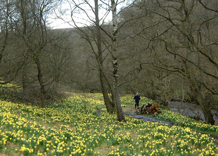
The Farndale daffodils attract crowds of visitors each spring and the narrow lanes become gridlocked with traffic. Avoid the crowds and the traffic by taking this back way into Farndale. This walk features the complete mix of North York Moors scenery – valleys, woodland, bleak moorland and of course the daffodils.
Fact File
|
Distance
|
17km/10˝ miles
|
|
Time
|
5 hours
|
|
Map
|
OS Explorer OL26 North York Moors West
|
|
Start/Parking
|
Park tidily in Gillamoor;
grid ref: SE 682 899
|
|
Terrain
|
Field and moorland paths, bridleways, and minor roads
|
Grade
|
*** (moderate/strenuous)
|
|
nearest Town
|
Pickering
|
|
Refreshments
|
Pub & shop in Gillamoor. Tea room at Low Mill (Daffodil time only)
|
|
Toilets |
Low Mill
|
|
Public Transport
|
Moorsbus serves Gillamoor Sundays & Bank Holidays (Easter – October) and daily in School summer holiday. Farndale 'Shuttle' from Hutton-le-Hole at Daffodil Time.
|
|
Suitable for
|
for everyone.
|
|
Stiles
|
12
|
- (Start) From the centre of Gillamoor walk west along the minor road to the neighbouring village of Fadmoor. At the triangular green, bear right to find a footpath sign and a new stile on the left just past a farm. The path now heads diagonally across six narrow fields from stile to stile. All but the last field are for grazing and will probably contain sheep or cattle. The last field is usually arable and it may be easier to skirt round the edge rather than cut across. Upon leaving this field you find yourself above the wooded slopes of Kirkdale.
- (2.4km/1˝ miles) Turn right along a narrow path, which drops down through the trees to a gate into an open field. Continue down the field to another gate and the Sleightholmedale Road. Turn right along the road past a row of traditional farm buildings. In about 800m (˝ mile) at a bend take to the bridleway through a gate on the right. Until a couple of years ago this way crossed a large expanse of open pasture. Now this has been divided up with new fencing and much tree planting has taken place. Follow the new fence over a gradual rise and down to a gate. Continue forward with a hedge now on your right, through another gate and up to join the access road for Stonely Woods – the impressive property that has been visible across to the left. Walk along the lane down to the junction with the Gillamoor road.
- (5km/3Ľmiles) Turn left up the road for about 800m (˝mile), passing two farms, to come to a footpath gate on the right, at a corner of woodland. Take this narrow path through the trees and into more open scrubland – the peaty ground underfoot can be quite wet. The path swings left to a gate in a wall. There is a good view towards Hutton-le-Hole from here. On the skyline ahead can be seen the farm buildings at Harland – our next objective. Continue down to a stream, cross and bear left up the bank to a gate into a field. Head up the field side to another gate and across the next field to a gate by a barn at the farm. Turn left along the track towards another farm, and then right, at the footpath sign, past agricultural machinery. Walk up alongside the wall, through a gate and on to another gate and ladder stile in the corner.
- (7.6km/4ľmiles) Here there is a dramatic change in the scene, from upland gazing land to open moorland. The path, though narrow, picks its way quite clearly through the heather. Cross a sandy track and continue through the heather – no doubt disturbing the occasional grouse as you do so. Quite suddenly you arrive at the edge of the moor overlooking Farndale. Across the valley stretches Blakey Rigg, with the Lion Inn just visible on the skyline to the north. Walk along the edge of the moor, passing old quarry workings. The route now descends diagonally into the valley down a seriously eroded path. The buildings and parked cars at Low Mill can be seen down in the valley. This area makes a good spot for lunch, sheltered by the wall with views across the valley, or you may wish to press on to Low Mill. Cross over a stile by a gate after which the path drops steeply through woodland, then through a gate into open pasture. At a lane, cross over taking a narrow path by a cottage, down the side of a paddock and through the garden of another cottage. Walk down the road to Low Mill turning left for the toilets and tiny post office.
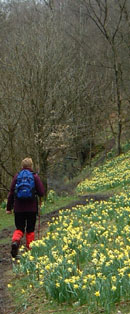
- (10km/6˝ miles) The tourists will all be following the main daffodil walk north from here up to Church Houses. We head the other way, left at the road junction and up to Daleside Road. At the bridge over the river you will get your first real site of the daffodils that adorn the riverbank and draw the crowds here each spring. Turn south along Daleside Road. You must walk along this road for about 800m (˝mile) – take care because it can be quite busy. Just before the buildings at Rawson Syke, fork right to gate leading onto an ancient green lane. There is no sign, but it is classed as ‘other right of way’ and is well walked. In about 100yds, a yellow way-mark indicates a footpath through a gate down the field towards the river. Ignore this because we are keeping to the old green lane for about a mile along the eastern side of the dale. For most of the way the lane is enclosed and easy to follow. It can be rough, wet and very muddy in places but this all adds to the adventure! Across the valley can be seen the moor crossed earlier in the day. After crossing the track leading to Bee Stone Farm, the surface of the lane has been dressed with stone. Whilst eliminating the problem of mud, it is harder on the feet. A stream tumbling down the hillside is forded and the path bears right down alongside a wall. At the bottom cross the river by the footbridge.
- (13km/8˝miles) The wooded riverbanks here provide the best display of daffodils on this walk. In fact I prefer this yellow carpet among the birch trees to the more dense expanse of daffs on the ‘tourist path’. Go through the metal gate and walk downstream leaving the main display of daffs behind as you head into thicker woodland. The actual right of way branches left back down towards the river. (The clearer path up through the woods is not a right of way – as I discovered after having gone that way!). Down by the river you come to a gate – where there is a choice of three routes onward to Lowna. You can either continue straight on along the river bank, or cross the river to Birch Hagg House then through the woods, or turn right up by the wall to another gate, opposite the unofficial path. Taking this third option, go through the gate and walk by the wall through scrubland to the edge of more woodland. On the right is a walled Quaker Burial Ground. Continue through the trees round to a ford and footbridge crossing Harland Beck. From here a track leads to the road above Lowna Bridge.
- (15km/9˝miles) It is now less than a mile up the road to Gillamoor – but it is all up hill! Gillamoor church can be seen on the hilltop ahead. Turn right along the road passing the turn to Farndale. Initially it is better to walk on the left-hand side where there is more verge to avoid traffic, but where the gradient becomes steeper and the road narrows, cross to face oncoming traffic. The going levels out and Gillamoor Church comes into view. At the corner, a seat is situated at ‘Surprise View’ next to a plaque set into the wall. The surprise is, of course, if you are travelling from Gillamoor and you suddenly come upon this view across Farndale. From 'surprise view' it is now but a short way through the village back to your car.(16.5km/10˝miles)
Along the Way
Gillamoor - A typical moorland village with a broad main street. Look out for the unusual sundial on the right as you walk back through the village at the end of the walk.
Farndale - In the daffodil season the local WI serves teas in the village hall at Low Mill on Sunday afternoons, and the National Park has a mobile information centre in the small car park. Weather permitting the field next to the village hall is opened as additional car parking at this time of year. A Moorsbus shuttle service links Hutton-le-Hole with Low Mill and Church Houses.
Arnold Underwood & HWC (April 2004)
|