
|
NORTH YORKSHIRE - FILEY - 15.2km (9Ẅ miles)
'Clifftop & Countryside'
The route follows field paths, tracks, and minor roads, taking in parts of both the Cleveland Way and the Yorkshire Wolds Way. You will experience the contrast between the dramatic Gristhorpe and Lebberston cliffs and the pastoral scene around Gristhorpe and Muston villages. Some care is needed on this cliff-top section.
Fact File
|
Distance
|
15.2km (9Ẅmiles)
|
|
Terrain
|
Cliff-top and field paths and minor roads
|
|
Time
|
4Ẅ hours
|
|
Stiles
|
8
|
|
Grading
|
*** Moderate
|
|
Suitable for
|
all but care needed on clifftop path and crossing railway track
|
|
Start/Parking
|
Filey North Cliff Country Park pay-and-display (grid ref: TA 120813) |
|
Nearest Town
|
Filey
|
|
Refreshments
|
Wide choice in Filey, plus pubs near/in Lebberston. Café at North Cliff Country Park
|
|
Toilets |
North Cliff Country Park
|
|
Public Transport
|
Trains to and from Scarborough, Bridlington and Hull (Wolds Coast Line).
East Yorkshire 120 & 121 buses from Scarborough, Bridlington and Hull; Coastliner 845, X45 from Malton with connections/through buses from Leeds and York (depending on season)
|
|
Map
|
OS Explorer 301, Scarborough & Bridlington
|

Route created using TrackLogs Digital Mapping
Image reproduced with kind permission of Ordnance Survey and Ordnance Survey of Northern Ireland.

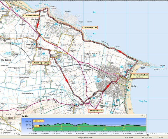
- (Start) From the car park head to the top corner overlooking Filey Brigg. Here an engraved rock sculpture marks the meeting point of the Cleveland Way and the Yorkshire Wolds Way. Set off along the cliff top path alongside a wider expanse of grass known as Newbiggin, now in the care of the National Trust. Continue along Newbiggin Cliff and round Cunstone Nab.
- (4.0km/2Ẅ miles) Here the air is filled with the sights and sounds of kittiwakes, which nest on the cliffs in their thousands. There are also puffins and other species of gull to be seen. You pass a caravan site, where some caravans seem perilously close to edge of the 200ft Gristhorpe Cliff. Below, at low tide, an expanse of rocks known as a wave-cut platform is revealed seals can sometimes be spotted basking on the rocks.
- (6.4km/4 miles) The path drops down to cross an area prone to landslips then climbs back up onto Lebberston Cliff. To the north there is the sandy beach of Cayton Bay, with Scarborough beyond. At a footpath sign you turn away from the cliff top and walk down a field edge to join farm road from Mount Pleasant Farm down to the former main road. Turn left along this road towards the Plough Inn and petrol station at a roundabout on the A165. Cross this road with care to the B1261 opposite and walk towards Lebberston. Follow the road past the Ox Inn and round the corner through the village towards Gristhorpe. You must walk about 0.5km along this road. There is no pavement so keep on the right to face oncoming traffic. Relief from the road comes at bridleway sign on the right. Turn down this track into Gristhorpe.
- (9.6km/6 miles) Opposite a row of cottage a footpath sign indicates you route past a farm yard and on down the left-hand side of a field. After crossing a drain the path again keeps to the left side of the next field. At the corner of the field you cross the Scarborough railway line, and soon after another footbridge over a drain. After a right-left zig-zag the route follows a dead straight course towards Muston. At first along field sides then on the track from Carr House. Other paths merge and you continue along Carr Lane to reach a small triangular green on the edge of Muston.
- (12.4km/7ẅ miles) Here you join the Yorkshire Wolds Way for the final leg to Filey. Some steps lead up at the far end of the row of cottages. Behind the cottages cross a couple of fields to a stile and the A165 road. Cross over with great care. The Wolds Way now follows a hedgerow across a large area of grazing for cattle and on past the back of Filey Comprehensive School. Here you meet a driveway leading to The Dams Nature Reserve. Turn right along the drive to reach the main road into Filey. Turn left and walk into town over the level-crossing to a roundabout, Turn left, cross the road and where the main road bears left continue straight ahead to a narrowing street that leads to a footbridge over XXX. At the parish church, go left along the footpath high above the road. At the end of the wall turn left onto an open grassy area. Cross this to arrive back at the car park at North Cliff Country Park.(15.2km /9Ẅ miles)
Along the Way
Filey is a quiet resort that has avoided the commercialisation that is commonplace elsewhere. The 6 miles of safe beaches are ideal for young children, whilst older holidaymakers can stroll on Royal Parade, or in Glen Gardens.
Coble Landing - Cobles are the colourful fishing boats, which here make a picturesque scene drawn up on the long ramp leading from beach to promenade. Here too is the Filey life-boat station.
Filey Brigg - the rocks here extend well out to sea and can be explored at low tide, but take care not to be cut off by the incoming tide.
Yons Nab - part of Lebberston Cliff of much interest to geologists, because here the Red Cliff Fault causes an abrupt change in the rock strata.
 Arnold Underwood (March 2012)
|
