|
EAST YORKSHIRE HERITAGE COAST
Flamborough Headland
The area was defined a Heritage Coast back in 1979 for its scenery, its wealth of bird and marine life, wild flowers, and geological and historic features.
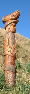
An ideal walk for the winter months, providing the weather is not from the north-east. There are numerous options for shortening the walk if need be, as several roads and paths radiate from Flamborough village towards the coast. Additional interest is provided by the 'Waymarker Trail' Wood Sculptures round the Headland from Danes Dyke to Thornwick Bay, and the 'Sculpture Trail' at South Landing. Leaflets available from local shops and cafÚs.
Fact File
|
Distance
|
12.5km/8 miles |
|
Time
|
4hours
|
|
Map
|
OS Explorer 301 Scarborough, Bridlington & Flamborough Head
|
|
Start/Parking
|
Car park at Danes Dyke (Pay & Display in summer) Grid Ref:TA 215 695
|
|
Terrain
|
Cliff-top paths, field paths and minor roads - take care on exposed cliff edge, parts of which are liable to subsidence. |
|
nearest Town
|
Bridlington
|
|
Refreshments
|
Pubs & cafÚs (some seasonal) at Danes Dyke car park,South & North Landing, and in Flamborough village |
|
Toilets |
Danes Dyke car park, near the lighthouse, and at North Landing
|
|
Public Transport
|
East Yorkshire buses from Bridlington |
|
Suitable for
|
everyone.
|
|
Stiles
|
6
|
- (Start) Walk down the path from the car park towards the sea. Just before the shore take the steep flight of steps on the left up onto the cliff-top. At the top bear right to follow the edge of the cliffs round Flamborough Headland. Navigation is easy û just keep along the cliff-top as far as the lighthouse. The walking also appears easy, but donÆt be deceived û there are several steep flights of steps to negotiate where gullies cut through the cliffs to the sea.
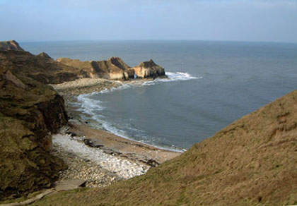
- (1.6km/1 mile) One of these ædown & upsÆ occurs at South Landing, where you may want to pause to view the lifeboat station which now houses the inshore rescue boat.At the bottom of the steps stands the 'Fisherman Sculpture'. Back up the steps bear right to take the cliff-top path - which here coincides with the 'Sculpture Trail' for a short distance. As you make your way along the undulations, Flamborough lighthouse seems a long time coming û itÆs about 2 miles from South Landing. Follow the sweep of the headland round past the fog signal station and up to the lighthouse. There are toilets and refreshments at the car park, and buses back to Bridlington. At a footpath sign by the beacon, you can drop down to find picnic tables, overlooking Selwicks Bay. An ideal spot for lunch, sheltered from the wind that often sweeps across the Headland. Here you'll find the 'Gannet', the next Sculpture on the Waymarker Trail and a north-facing Topograph.
- (4.8km/3╝miles) At the footpath sign for North Landing, continue along the cliff-top, which is liable to subsidence, with the golf course on your left. The route is straightforward and in places you have options of either keeping close to the cliff top or following a more direct (and safer!) path away from the edge. After a mile or so, you arrive above the little bay of North Landing, with its chalk pinnacles and caves. The path swings round, passing the little chalet village that was the centre of a dispute with developers in 2002. The occupant of one provides walkers with some light entertainment with his display jokes, sayings, and other remarks by the path. There is a collection box for donations, which go towards cancer research.
- (7km/4¢miles) At North Landing there are refreshments (not winter) and toilets. Another sheltered spot for a break is down on the rocks in the cove. Flamborough village is about a mile down the road, for those wanting to cut out the next section. Otherwise, rejoin the cliff-top path at the far end of the car park. Soon you are faced with another of those gullies. The path descends diagonally to cross a small stream by a footbridge, then up the other side.(NOTE: I have heard that subsidence has caused the collapse of this footbridge - diversions are in force - Jan 2006) You cross a stile into an enclosed paddock. The ground here had been badly cut-up by horses, with one narrow section being particularly difficult to negotiate. A stile on the right brings you back to the cliff-top and easier going. Once again the path swings inland but this time do not turn down the steps. Continue to meet a narrow road, cross straight over and walk up by the side of a fence towards a house (Thornwick Farm), near to a large caravan site. Pass to the right of the house then left along the caravan site access road. At a bend continue straight on alongside a hedge to the road, and turn right towards Flamborough village.
- (9.5km/6miles) As you enter Flamborough, take the left fork towards the centre of the village. On your way through the village you will pass several pubs and two fish & chip shops. Turn right to reach the main road, then left. Cross over to walk along the pavement with the castle ruins on your right. Go round the sharp corner, and when safe to do so, re-cross the road opposite the church. Take the lane along the side of the church, and then the first right into Water Lane. At the end, a footpath sign points the way across open fields towards Danes Dyke Wood. It can be wet under foot across the first field. After crossing a stile follow the edge of the next field round to meet the exit road from Danes Dyke car park. A new footpath, surfaced with stone chippings, has been provided through the trees parallel to the road. A footpath gate on your right leads you back to the car park. (12.5km/8miles)
Along the Way
This end of Danes Dyke is a natural ravine, but that to the north, stretching for 2 miles across the Headland, is man-made and is thought to date from the Iron Age
Flamborough lighthouse was built in 1806 in an effort to reduce the number of shipwrecks along this stretch of coast. It stands 85ft high and was erected within a year by John Matson, a builder from Bridlington.
The Chalk Tower - this octagonal chalk lighthouse, is situated some distance inland from the modern lighthouse, and was built in 1674 by John Clayton. Up until 1836, lighthouses were built and run by private individuals.
Arnold Underwood & Caroline Gowthorpe (Sept 2003),& LWC (Revised Jan 2006)
|