|
EAST YORKSHIRE - Fridaythorpe
As featured in Country Walking Magazine December 2005
Wonderful Wolds Ways û from Fridaythorpe
The well-drained chalk landscape of the Yorkshire Wolds is ideal for winter walking. Winters can be hard for those living and working on the Wolds but firm ground and the clear air make it excellent walking country. This 9 mile circuit takes in some of the best the Wolds has to offer by using parts of the Wolds Way and the Chalkland Way.
Fact File
|
Distance
|
9 miles (14.5km) with a shorter 7 mile option
|
|
Time
|
4 hours
|
|
Map
|
OS Explorer 294 (Market Weighton & Yorkshire Wolds Central)
|
|
Start/Parking
|
Fridaythorpe by the village pond. Grid Ref. SE 875591
|
|
Terrain
|
Field paths, tracks & minor roads 
|
Grade
|
*** (moderate)
|
|
nearest Town
|
Driffield
|
|
Refreshments
|
Shop (at garage), Seaways cafÚ in Fridaythorpe |
|
Toilets |
none
|
|
Public Transport
|
Fridaythorpe is served by bus service 135 from Driffield
|
|
Suitable for
|
for everyone.
|
|
Stiles
|
3
|
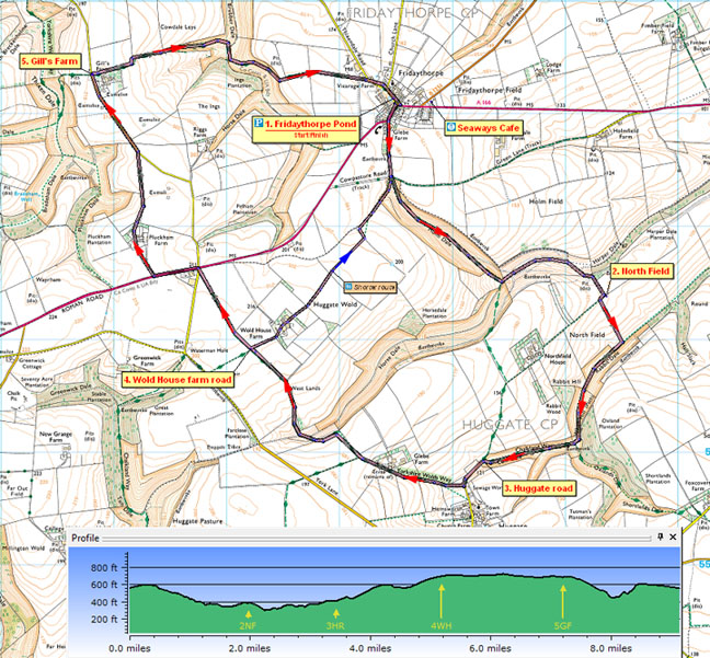

Route created using TrackLogs Digital Mapping
Image reproduced with kind permission of Ordnance Survey and Ordnance Survey of Northern Ireland.

- (Start) From the pond in Fridaythorpe walk back towards the main road and turn right along the pavement. Cross over the road and walk past some new homes. Where the main road bears right continue on down a lane, signed Wolds Way. In a further ╝ mile go straight ahead through a gate. There then follows a pleasant stroll down the grassy Holme Dale. At the bottom the Wolds Way bears right heading directly towards Huggate up the steep bank. However this route takes a pleasant detour, over a stile on the left, and round towards Harper Dale. As you approach a belt of trees, keep to the right and join a farm track up to the corner of the wood by a disused pit. Continue forward and turn right along the ridge towards Northfield Farm.
- (3.6km, 2╝ miles) Almost immediately, at the first hedge on your left turn down the hillside, keeping to the right of the hedge. This path is indicated by a yellow waymark may not be shown on OS maps. At the bottom turn right along Rabbit Dale and walk along this grassy valley, the slopes of which become wooded as you approach a divergence of dales. Do not cross the stile directly ahead but bear right, crossing another stile, into Cow Dale. Head towards the end of this dale to a gate onto a farm road, rejoining the direct route of the Wolds Way.
- (5.7km, 3¢ miles) Walk towards Huggate, but turn right along a road to Glebe Farm, still following the Wolds Way û which for some reason deliberately avoids Huggate village. Beyond Glebe Farm, at a bend, leave the Wolds Way and take the path to the right along a field edge. A gate brings you out high above Horse Dale, where you turn left and descend diagonally into the valley.
Cross the fence and swing right up the head of the dale to another gate. Follow a grassy bridleway along field sides to the road to Wold House Farm. (For a shorter walk turn right here to pass David MidgelyÆs Statue at Wold House Farm and head directly back to Fridaythorpe.)
- (8.5km, 5¢ miles) To continue, cross the farm road and continue ahead along field edge for ¢ mile to a junction with the A166 York Road. Walk along the left verge past the grain store for 200yds and as you approach the junction on right for Pluckham Farm, cross the road with care. Walk along the access road towards Pluckham Farm and bear left to follow a track past the farmhouse into trees. Emerge from trees and continue by hedgerow along top of fields overlooking Pluckham Dale to join a road. Continue along road for ¢ mile to Gill's Farm.
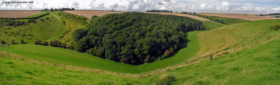
- (11.5km, 7 miles) Past farm entrance turn right through the gate to follow the Wolds Way down the side of the farm (old maps may show the path going through the farm û this was changed many years ago). The clear track turns left then right down to a gate in Brubber Dale û not cutting diagonally across as shown on older maps. at bottom through another gate bear right as indicated by the Wolds Way sign and take the track that climbs diagonally up the left-hand side of the dale. This is the final climb, you will be relieved to know, and is followed by a level ¢ mile along field sides, past a large animal-feed mill into Fridaythorpe. Turn right along the lane to the pond, behind which a new housing development stands on the site of Mere Farm. Take a few minutes to visit the historic little church tucked away behind buildings on your left.(14.4km/9 miles)
Along the Way
Fridaythorpe is a small village on the main York to Bridlington road. Its main claim to fame is for being the midpoint of the 80-mile Wolds Way national trail from the Humber Bridge to Filey. It was here that the Wold Way was officially declared open in October 1982. A sign, by the pond, commemorates the 21st anniversary of the Wolds Way.
Arnold Underwood & Caroline Gowthorpe/LWC (Jan/Feb 2004) Revised Sept 2020
|