|
SOUTHERN SPAIN - ANDALUCIA
How about something completely different? Why not head for sunny Spain and experience walking in Andalucia.
Dales Trails has did just that in Oct 2007 and can highly recommend it to any reasonably fit and experienced walker.
If you can cope with the North York Moors, you should have no problem in Andalucia.
Flights from several UK airports will get you to Malaga in under 3hours. Nerja is then less than hours drive east along the N340 motorway. Frigiliana is about 6km north of Nerja.
Dales Trails walking holiday was organised by Dave & Gill Armstead who run Walk Andalucia. They offer guided and self-guided options – we went for the latter but, be warned, Spanish mapping is not a patch on our OS Maps!
The walk described here is one of four we did. In terms of mileage, it may not be long but it packs a lot into a small space.
FRIGILIANA TO LA CRUZ DE PINTO (8km/5miles) 'Stairway to Heaven'
Fact File
|
Distance
|
8km (5miles)
|
|
Terrain
|
Stony tracks & paths. Very steep ascents and descents by zig-zag paths
|
|
Time
|
4˝ hours
|
|
Stiles
|
none
|
|
Grading
|
*** Moderate
|
|
Suitable for
|
experienced walkers
|
|
Start/Parking
|
Frigiliana Square - Plaza del Ingenio (Market on Thursdays)
|
|
Nearest Town
|
Nerja
|
|
Refreshments
|
Bars and Restaurants in Frigiliana
|
|
Toilets |
Frigiliana car park
|
|
Public Transport
|
Bus service from Nerja, about every hour (not Sundays)
|
|
Map
|
Mapa Topografico Nacional de Espana 1054-II
|
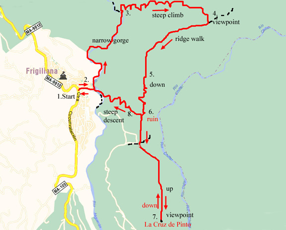
- (Start) From the parking area by the main road (MA-9012), walk up the slope to the Plaza del Ingenio. At the top, continue ahead and walk through the gap between buildings. Pause by the railings to survey the panoramic view spread before you. This walk takes you down into and along the gorge carved out by the Rio Higueron, then up the other side and back along the ridge in front of you. You will then head for a viewpoint on La Cruz de Pinto (not visible from here) before returning down into the gorge and back up the hill to the village.
- Walk down the concrete roadway right to the bottom of the gorge to where it meets the rocky dry riverbed. The route now follows the riverbed north into the gorge. The path actually keeps to the riverbank, crossing to and fro at meanders, but as there is only water in the river after torrential rainstorms you can easily walk along the riverbed most of the time. (I would not recommend you do this walk after heavy rain or if storms are forecast). On the left a water pipe links the village with a pumping station on the valley floor. The wooded slopes of the gorge and the rocky crags are home to a variety of wild life – look out for Ibex, birds of prey, and smaller birds, including Black Wheatears. Continuing along the gorge you pass the ruins of a stone building and come to a concrete building housing an electricity substation.
- Pass to the right of this building and a pylon and look out for a narrow path on the right near a green 'Parque Natural' sign. This path is your way out of the gorge. It is narrow but clear and the gradient is lessened by zig-zags. It is a long way to the top, but thanks to the many zig-zags it is not too steep and trees and shrubs hide the steep drop! Take it at a steady pace with frequent stops to look back across the gorge. At the top a panoramic view of the mountains to the east suddenly opens out before you – it is worth the climb.
- Here there is waymark, pointing left, but your way is to the right. Follow a narrow path along what is in fact a ridge with the gorge you set out along way down to your right. Fortunately the steep hillside is cloaked with trees and bushes obscuring the steep drop. It’s a bit tedious at times ducking and weaving through the undergrowth, but the path so far is clear enough. Eventually you emerge from the trees onto a more open hillside. Ahead is a rounded hill - La Cruz de Pinto – and over to the west, part of Frigiliana perched on its ridge above the gorge.
- The next bit is tricky because the path loses its way down the hill. Basically you must pick your own way down through the scrub and rock whilst aiming for that round hill directly ahead. As you encounter denser undergrowth the path becomes a bit clearer, and occasional blue marks on the rocks help restore your confidence! Eventually the gradient levels out and the path winds its way through bushes towards a ruined stone building. By a ‘Parque Natural’ sign you merge with another path (your return route to Frigiliana) where you bear left past the ruin.
- From the ruin, the path climbs over a small ridge and follows the contours round the other side before swinging back towards the round hill – your ultimate target. The narrow path joins a broad track and you pass a log – a convenient seat. Just beyond this, leave the wider track for a narrower path going left which curves round to climb across the eastern flank of the hill. The hillside drops away quite steeply to your left and there are a couple of tricky but not serious little scrambles over rocks but within 10mins you reach a col below the main summit. From there the path picks its way up the hill, akin to climbing the last bit to the summit of Roseberry Topping! Here there is no trig point on the summit but a white painted obelisk with a cross. You have arrived at La Cruz de Pinto.
- From here there is a 360 degree panorama from the Almijara mountains to the north to the Mediterranean Sea to the south. Nearer to you there are butterflies of all kinds including large Swallowtails, feeding on the nectar of the lavender growing here.
After a break taking in the sights, you must retrace your steps downhill back to the ruin passed earlier. Take care on the way down. At the ruined barn take the left fork and start the descent. Frigiliana is just across the gorge, with the old sugarcane mill prominent – it is about the only building not currently painted white. Although the village seems so near, to get back there you will have to descend into the gorge…and then climb up the other side!
- The path zigs-zags down, tricky in places where it has been gouged out by recent heavy rain. Also there are bare slabs of rock in a couple of places which you should negotiate by whatever method you feel most comfortable and secure with – on your bottom? Trend right, ‘upstream’ where there is a choice, and eventually you come to the last bit of scrambling down to the river bed. Walk up river and round a bend past sugarcane and you reach the concrete track down which you came a few hours earlier. Turn and plod uphill back into Frigiliana and treat yourself to a welcome drink in one of the bars or cafés.
Along the Way
Frigiliana -
Barely 5km inland from Nerja, lies one of the most beautiful villages of Spain that has won many national and regional awards to prove it. With a population of around 2,000 it is well cared for day-by-day, to keep up its high standards. Situated in the foothills of the Almijara mountain range, Frigiliana has spectacular views of the Higueron River valley. It has a sub-tropical climate which has attracted a people here since pre-history. The Romans built a fort here but unfortunately nothing remains. The history of the village is pictured in 12 mosaics in the old quarter, created by Pilar Garcia Millan.

|