
|
NORTH YORK MOORS – 14.4km (9 miles)
COUNTRY & COASTAL
Field and woodland paths take you towards the River Esk which is crossed by means of the former Larpool railway viaduct. After dropping down into the hustle and bustle of Whitby the 199 'Church Stairs' take you up to the church and Abbey with panoramic views back over Whitby.From there the Cleveland Way takes you back along the clifftop to Hawsker.
Fact File
|
Distance
|
14.4km (9 miles)
|
|
Terrain
|
Field and woodland paths & tracks, and cliff-top path
|
|
Time
|
5 hours
|
|
Stiles
|
8
|
|
Grading
|
***Moderate - 199 steps in Whitby and undulating cliff-top path
|
|
Suitable for
|
All (but care needed on exposed clifftop)
|
|
Start/Parking
|
Hawsker (lay-by or village hall) Grid Ref: NZ 924 078 |
|
Nearest Town
|
Whitby
|
|
Refreshments
|
Pub in High Hawsker, tearoom at Hawsker Caravan Site, and lots of choice in Whitby (including fish & chips of course!)
|
|
Toilets |
Whitby (near station and Abbey)
|
|
Public Transport
|
Arriva (North-east) X93 bus: Hourly Middlesbrough-Whitby-Scarborough serves
Hawsker
|
|
Map
|
OS Explorer OL27 North York Moors (East)
|

Route created using TrackLogs Digital Mapping
Image reproduced with kind permission of Ordnance Survey and Ordnance Survey of Northern Ireland.

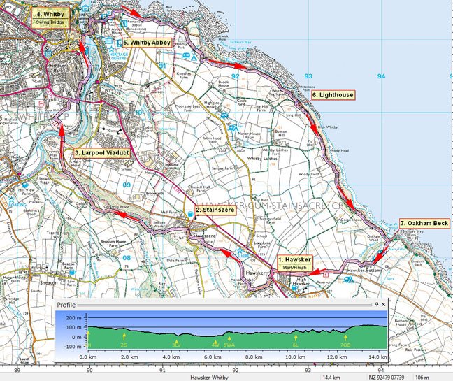
- (Start) From Hawsker village hall or the lay-by on the green by the A171, head down into Low Hawsker. In about 200m fork right along a driveway and then bear right along by hedge avoiding Hawsker Hall Farm. Enter field and keep alongside hedge on the left following it round to the right and down to Stainsacre Beck. These field paths are not frequently walked, as the disused railway (now National Cycle Route 1) provides an easier if less interesting alternative. Directly ahead can be seen the former Hawsker station, now a base for cycle hire. In the overgrown corner of the field, the beck provides the only major obstacle on this walk – as a footbridge across has long gone. Hopefully there will not be too much water in the beck as you scramble down and up the other side. Safely across, in the next field, walk parallel with the beck along a delightful wooded section, particularly in spring with bluebells, garlic, primroses etc. Emerging from the trees, keep to the top of a bank that swings right and you come to a junction of paths. Take the one to the left which leads you Stainsacre Lane where you turn right into the village.
- (1.6km/1 mile) Opposite the road junction in Stainsacre, take a footpath past playground and playing field with Stainsacre Hall (now an outdoor pursuits centre) to you left. The path keeps to right of a playing field, after which a mown strip leads you down into the woods below the Hall. The path zigzags down through the trees to join a track by the beck which is forded or crossed by a footbridge. Follow the main track up from the beck. This swings right and can be muddy and rutted but at the top emerges at a junction with a lane on Long Rigg. Ignore the path straight ahead, and turn right along the lane. This lane heads down the ridge between Rigg Mill Beck and Stainsacre Beck to Cock Mill. Pass the entrance to Cock Mill Hall and continue into this delightful hamlet. Take the right fork up a driveway passing garages to find in the corner, a flagstone path leading down past Waterfall Cottage with landscaped garden overlooking the stream and a waterfall. The path now heads down this wooded dale to meet a road below Larpool Hall. Take care on the next stretch as you walk up the road as far as the former railway bridge. Cross the road and go up the steps to left of bridge onto the track-bed, now part of the National Cycle Network. Turn left and you are soon on Larpool Viaduct, high over the Esk Valley.
- (4.8km/3 miles) Cross the viaduct and at the far end continue to a footpath sign and turn right to follow an path between fences across school playing (this path is signed as temporary, so it may be changed in due course). Walk out of the school and turn right along the higher footpath towards the A171 Esk Viaduct. Do not cross this busy road but take a narrow path on the right through bushes, and follow this path round and under the road bridge. Up steps join anoth path which leads down into Whitby, with views ahead of the marina, to meet a road. Bear right to drop down alongside the railway and cross the railway by way of the gated pedestrian crossing to bring you onto the quayside. Keep over to the right to avoid the large car park and walk alongside Whitby’s riverside moorings. Eventually you must rejoin the roadside pavement opposite a supermarket and the railway station. Hereabouts you will also find the tourist information centre, toilets, and a choice of food and drink outlets.
- (7.6km/4ľ miles) After exploring the town you will need to cross the swing bridge and immediately turn left into the old town. Cut up through Market Place onto Church Lane and go left and come to the foot of the ‘Church Stairs’ – the 199 steps up to the church. Set off up the steps – there is no need to count them as every 10th step is marked with roman numerals on a small brass disc. The 199th (CXCIX th) step is also marked. From here there is panoramic view over the rooftops of Whitby. Time permitting it is worth exploring the church and the Abbey. An open space opposite the Abbey provides a good place for a lunch break, away from the crowds down in the town. Walk past the Abbey and turn left to join the coastal path – the Cleveland Way. It is now a simple matter to follow this path south until turning off for Hawsker!
- (8.5km/5Ľ miles)For the next 3miles the path hugs the cliff-top, sometimes on the ‘wrong side’ of the fence with a steep drop to the rocks and waves below. The route might be straightforward but it is not an easy stroll – there are numerous stiles, and downs & ups to negotiate. At Saltwick Nab the path cuts across the headland through a caravan site and a little further, after passing a fog station the path again turns away from the cliff-top to pass behind a lighthouse.
- (11.7km/7Ľ miles) Back on the cliffs the path rises over Widdy Head and passes below Widdy Field Farm. After a seat comes a path on the right to Hawsker, which you could take. However our route can continue a little further along the cliffs crossing two more gullies. The second one, containing Oakham Beck, is scattered with gorse and in spring its slopes are blessed with Early Purple Orchids.
- (113.6km/8˝miles) Just up from the beck take the path, right, that climbs up to a caravan site. Continue up past the caravans which are surprisingly situated on quite a steep slope. Follow the access road out past the site shop and tearoom, which is well-worth a visit, being fairly near the end of the walk. At the top of the hill, the road is crossed by the former railway (National Cycle Route 1). Turn right along here for the final km back to Hawsker, but be aware of cyclists. The way passes under a bridge and brings you to a pelican crossing on the A171. Cross here to reach the village hall or lay-by. (16km/10miles)
Along the Way

Larpool Viaduct
The railway down the coast was closed in the 1960's and much of the trackbed towards Scarborough was converted into a recreational path and cycleway. The impressive viaduct across the Esk Valley was closed off for Health & Safety reasons and stood derelict for many years. However in recent years a change of attitude has seen it restored and resurfaced to carry the path and cycle route, now part of the National Cycle Network, across the valley.
Whitby Abbey
The Abbey ruins stand next to St Mary's Church, overlooking the old town of Whitby clustered art the mouth of the River Esk. Like all Abbeys, it suffered at the hands of Henry VIII but still the gaunt silhouette of the ruin presents a dramatic sight against the sky, particularly at sunset.
The 199 steps, known as the Church Stairs, lead from the Old Town up to St. Mary's. Every 10th step, and the last, are now numbered, with Roman numerals, on small brass plates - so you don't have to count them any more!
Arnold Underwood (May 2009); Revised May 2015
|
