
|
NORTH YORKSHIRE - Hovingham
Caulkeys Bank and the River Rye
This is a pleasant walk in area overlooked by many as they head for the nearby North York Moors. Extensive views can be had from Caulkley’s Bank, before dropping down to follow the meanders of the River Rye through Nunnington
Fact File
|
Distance
|
15.2km/9˝miles
|
|
Time
|
4 hours
|
|
Map
|
OS Explorer 300 (Howardian Hills and Malton)
|
|
Start/Parking
|
Hovingham Village Hall
|
|
Terrain
|
Field paths and bridleways, which can be muddy in places.
|
Grade
|
*** moderate
|
|
nearest Town
|
Helmsley
|
|
Refreshments
|
Two pubs and two tea-rooms in Hovingham. Pub and Studio tearoom (seasonal) in Nunnington
|
|
Toilets |
None
|
|
Public Transport
|
194/195 Malton/Helmsley – Hovingham.
|
|
Suitable for
|
all
|
|
Stiles
|
5
|

Route created using TrackLogs Digital Mapping
Image reproduced with kind permission of Ordnance Survey and Ordnance Survey of Northern Ireland.

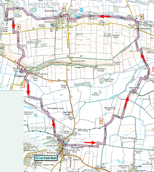
- (Start) Next to the village hall a footpath heads alongside the Malt Shovel inn past rear garden and bowls green into fields. Here continues as a broad margin along field sides, clearly waymarked where it zig zags but otherwise maintains an easterly direction. Eventually you reach a footpath ‘cross-roads’ and here you should turn left. Continue round the edge another large field to a farm road.
- (2.0km/1Ľmiles) Turn right and walk along this road until nearing Tuft House Farm. Here go right along a bridleway round the edge of more fields to reach South Holme Farm. Take care here as there may be a single strand wire across the track. Skirt round outside of the farm yard with an open field on your left. A line of electricity poles can be seen heading north across this field. The path follows this line of poles across the field to a gap in the hedge. Go through and turn right alongside the hedge and follow it round alongside tall conifers screening Beech Tree Farm.
- (4.0km/2˝miles) Join the farm road for a short distance, but where it turns right, you should continue straight ahead (fps) by the hedge towards Caulkleys Bank. After crossing a beck, you start climbing gradually and as the gradient increases keep left of hedge and trees to find some steep steps up the bank. Take a break here to take in the view back across to the Howardian hills. At the top of the bank is currently an overgrown set-aside area. Go left to the edge of this and then right to follow the side of the field marked by a few trees over the brow of the hill down to some barns. Here you now have a view north across to the distant moors. At the barn turn right down the track to reach a road. Cross over and walk down into West Ness.
- (6.0km/3ľ miles) Walk along the road through the village towards the river bridge. Here go through a gate to join the riverside path to Nunnington. A pleasant stroll ensues by the River Rye until the path cuts out a meander of the river by heading straight for the former water mill. This is an impressive building albeit now used only for storage for the adjoining farm. Pass through gates between the farm and mill and across the fields through more gates to reach the wall around the gardens of Nunnington House. A small gate in the wall permits a view of the rear of the Hall. The r.o.w now swings left (ie to the south) of buildings to a stile in the corner. Cross and walk down the road to Nunnington Bridge by the entrance to Nunnington Hall (NT).
- (8km/5 miles) Take the road into the village. Here there is a pottery and tea-room (restricted opening in winter) and a photo gallery. At the corner, go through a gate to rejoin the riverbank. (The Royal Oak inn is further up the road). Continue to follow the Rye for the next mile. If not lunching at the café or pub, there are places here where you can drop down the riverbank to find sheltered spots to sit by the river. Continue by the river until the path heads straight alongside Low Moor Plantation leaving the river to complete some tortuous meanders. At the corner, go left through a gate then right alongside Plump Wood, not in the wood which is private. Upon meeting a farm road (SP) go left here along this track. Across the field to the right is the embankment of a long-gone railway with the buildings of the former Nunnington station in the distance. The farm track goes left then right, around woodland and climbs gradually up to the road from Nunnington.
- (11.2km/7 miles) Go left along the road for a few yards then right (SP Stonegrave) and follow this field side track over the hill. Again there are panoramic views north to the moors, and then as you drop down the other side, the views are ahead. The track zig-zags down the Bank to meet the Helmsley road near Stonegrave. Cross with care slightly to the left, to a sign-posted path (not yet shown on OS maps). Go down off the road through a gate and down the field sides until you are opposite Stonegrave church. Turn left across the field towards the church where at the bottom corner of the churchyard there are steps up. However a new FPS indicates that the footpath does not go through the chuchyard but goes along by the wall. (Be aware that if you use the steps into the churchyard, you do so at your own risk as they are becoming worn.) At the other side of the church walk through the village and turn right down the road to Cawton. Just over the bridge go left (SP Hovingham) to rejoin field paths back to Hovingham.
- (12.8km/8 miles) In the first field follow the track round to the right through gates/over stiles. Now the path keeps to a wide grassy margin round the sides of fields crossing a footbridge to continue on opposite side of the ditch & hedge towards some barns. Just before the buildings the path ducks through the hedge to avoid them and rejoins a farm track further on. This track swings left to follow the course of a former railway for a short distance. Then the farm track bears right off the disused railway and you head straight across the field to a junction of tracks (SP). Turn left here and heads towards Hovingham, passing through two gates and entering the village alongside the beck. Cross a bridge over the stream to emerge on the green and head across to the main road and the village hall. (15.2km/9˝miles)
Along the Way

Nunnington Hall has been around a long time - since the 13th century, in fact. The present hall dates from the 16th and 17th centuries, with the most significant alterations having been carried out during the 17th century when the estate was inherited by Lord Preston. It is in this condition that much of the house remains today.
Most of the furniture, porcelain, and paintings were collected by the late Mrs Ronald Fife who left Nunnington Hall to the National Trust in 1952.
The Hall and gardens are open to the public from March through till October.
Stonegrave Minster
Stonegrave church, The Holy Trinity or Stonegrave Minster, is the smallest Minster in the country and was mentioned in the Domesday Book. The Minster had probably been founded by an earlier King of Northumberland and was staffed by priests of the tradition of Iona and Lindisfarne. The west wall of the existing church may be a remaining feature of this earliest building. Fragments of early Celtic crosses were found during the restoration of the church in 1863, broken and built into the north wall of the chancel, where they had been placed when the Normans enlarged the building.
Hovingham Hall - Childhood home of The Duchess of Kent
For over 400 years Hovingham has been the home of the Worsley family. The Palladian house was built between 1750 and 1770 by Thomas Worsley to his own design and is unique being entered through The Riding School.
Mr and Mrs William Worsley invite you to visit their historic 18th Century house set in beautiful Ryedale countryside, which is open to the public from 2nd June to 5th July 2008 (closed Sundays)
Arnold Underwood (March 2008)
|
