|
NORTH YORKSHIRE - Hovingham
A good walk for any time of the year across the rolling wooded countryside of the Howardian Hills, following a part of the Ebor Way via Terrington.
Fact File
|
Distance
|
17.5km (11˝miles) - but can be shortened to 13.5km (8˝ miles)
|
|
Time
|
4 hours
|
|
Map
|
OS Explorer 300 (Howardian Hills & Malton)
|
|
Start/Parking
|
Park at the village hall (next to the Malt Shovel inn) Grid Ref: SE 668757
|
|
Terrain
|
Field paths, bridleways & minor roads. Can be muddy in places
|
Grade
|
*** (moderate)
|
|
nearest Town
|
Malton
|
|
Refreshments
|
McConnellTHOMAS organic, local, fair traded general store, deli and web café in Hovingham;
Spa Tearoom, Hovingham; Village Shop Cafe in Terrington; Pubs in Hovingham and Terrington
|
|
Toilets |
none
|
|
Public Transport
|
194/195 from Malton or Helmsley. Moorsbus in Summer months
|
|
Suitable for
|
for everyone.
|
|
Stiles
|
5
|
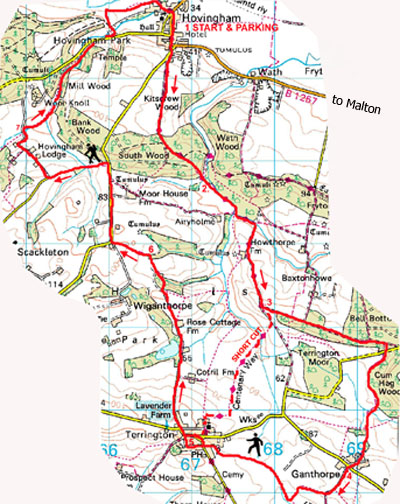
Image produced from the Ordnance Survey Get-a-map service.
Image reproduced with kind permission of Ordnance Survey and Ordnance Survey of Northern Ireland.

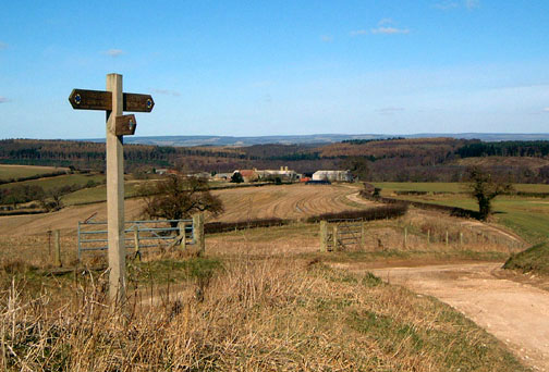
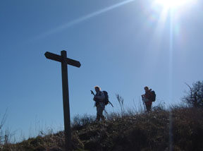
- (Start) From the car park at the village hall turn left (south) and walk past the Worsley Arms Hotel. At the corner, cross the road to join the footpath heading up hill. Walk up the road for about 200m and take the track forking left (SP Terrington). This track crosses open farmland with views back to the North York Moors, before dropping down into woodland. Follow the blue way-marks (SP Terrington Ebor Way) through the woods (some of which have been cleared and replanted) eventually descending to a gate. This leads to an open, boggy area. Pick your way across to a footbridge and another gate.
- (2.3km, 1˝ miles) Walk along the edge of woodland, looking out for a yellow way-mark by a gap on the left. Here turn into the woods and bear right (blue way-mark) and follow this path alongside a stream – again it can be boggy. At a meeting of another track turn left, through a gate cross a field (ignore path right) and through another gate. Follow the track, which swings right up to Howthorpe Farm. At the farm (dogs), walk to the left of the house, to keep on the main track. At the top of the next ridge there is an all-round panoramic view.
- (4.5km, 3miles) Here the track forks. For the shorter route go right down the track to a footpath sign pointing the way across the fields to Terrington. You arrive in Terrington by the school playing fields, passing the school entrance and the Church.
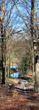
For the longer route take the left fork along the ridge. Walk along here for about 1.5km (1 mile) – with views north and south through gaps in the trees. At a blue (bridleway) way-mark turn right down through the trees to the road. Cross the road to the right to a gate and continue following the bridleway along the edge of woodland. Go through double gates into open pasture. Here bear right (no signpost) round the hillside to come upon a wire fence on your left. Keep along the right of this fence to a gate – it can be very muddy and rutted here! Through the gate keep straight on (not following the tracks right) to a small metal gate. Beyond this gate is the first of several small ponds. This is a picturesque spot with snowdrops, daffodils etc. The path picks its way up through the trees past the ponds to join a track leading to the green in the centre of Ganthorpe.
- (8.0 km, 5miles) Cross the road to continue down the lane opposite. After about 400m (Ľ mile) at a bend take a footpath right (hidden waymark) by the side of a hedge. Walk along the side of the field round the corner, keeping hedge on your right. At the end by a stream you meet another path (no SP). Turn right to follow the stream along the bottom of the next field – a way-mark post indicates the way through a hedge and continuing up the field side. Go left and then immediately right across another field, heading towards Terrington church tower. Cross a footbridge and one more field to gate/stile onto South Back Lane (East). Walk along the lane to a road junction – here you can either turn R then L up the main street (for shop, pub, & green) in Terrington, or go straight across up South Back Lane (West) where you can enter the pub through its car park and beer garden. Continue up Back Lane and look out for a narrow alleyway on R, 20m before end of Lane. This will bring you out onto the village green.
- (10.4km, 6˝ miles) From the green head up the road round the corner and at the next bend take the lane straight on. This lane heads across open country to the much modernised Sawmill Cottage on the right and a fishing pond (L) – more visible now after tree-felling operations. A little further you are warned of ‘Free-range animals & children’ ahead. The footpath is diverted up the other side of the wall past this hazard, rejoining the track beyond the former farm. Now just a tractor track, the route continues clearly across open farmland, but at a belt of woodland the route forks R off the track down through the trees. Leave the trees past a ruined barn and walk along a field side. As you approach another belt of trees look out for a way-mark showing the route diagonally L across fields towards a marker post on the skyline and on to a cottage on the Hovingham road.
- (13.5km, 8˝ miles) Turn R and walk down the road for about 1km (take care – fast traffic). Near woodland go L onto a bridle-way along the side of fields (rutted) to reach a lane. Turn R and walk down the lane past Hovingham Lodge and round a double bend. Take the footpath R near the stream and head towards woodland. Cross stile and follow clear path through the woods to emerge on the road through Hovingham Park (take care on the road). Go left into the park to cross the ornate bridge over the stream with a good view of Hovingham Hall. Beyond the park turn R towards Hovingham joining a lane which brings you to a ford by the tea-room. Cross the main road and walk R back to village hall by the Malt Shovel inn. (17.5km, 11˝miles)
Along the Way
Hovingham is one of Yorkshire's prettiest villages. It lies along an old Roman road to Malton, and Roman remains have been found on the site of Hovingham Hall. This Palladian house was built between 1750 and 1770 by Thomas Worsley to his own design and is unique being entered through The Riding School and stables; the lawn is also the village cricket field!
For over 400 years Hovingham has been the home of the Worsley family and is the birthplace of Her Royal Highness The Duchess of Kent. The historic 18th Century Hall, set in beautiful Ryedale countryside, will be open to the public from Monday 5th June to Saturday 8th July 2006 (closed Sundays)
The Ebor Way long distance footpath from Helmsley to York passes through the village.
Arnold Underwood & Joyce Davidson (March 2006)
|