|
EAST YORKSHIRE - Huggate
As featured in the June 2007 issue of Country Walking Magazine
A circuit from the highest village on the Wolds
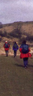
This is an ideal winter walk on the Wolds using grassy dales, bridleways and farm roads to the south of Huggate. The route crosses numerous minor roads, all of which provide alternative ways back to Huggate should the need arise. End your day with a drink and a hot beef sandwich at the Wolds Inn, or tea and homemade cakes at Rachel's Walnut Cottage Tearoom
Fact File
|
Distance
|
9˝ miles (15.0km) Can be shortened to about 8 miles
|
|
Time
|
4 hours
|
|
Map
|
OS Explorer 294 (Market Weighton & Yorkshire Wolds Central)
|
|
Start/Parking
|
Park tidily in Church Street or by the green in Huggate, or at the Wolds Inn with permission Grid Ref: SE 882550
|
|
Terrain
|
Field paths, bridleways & minor roads. Can be muddy in places
|
Grade
|
** (easy)
|
|
nearest Town
|
Pocklington
|
|
Refreshments
|
Wolds Inn, Huggate (01377 288217)
Rachel's Walnut Cottage Tea Room, Huggate (01377 288378)
|
|
Toilets |
none
|
|
Public Transport
|
limited shoppers service from Pocklington (Tuesdays only)
|
|
Suitable for
|
for everyone.
|
|
Stiles
|
5
|
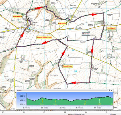

Route created using TrackLogs Digital Mapping
Image reproduced with kind permission of Ordnance Survey and Ordnance Survey of Northern Ireland.

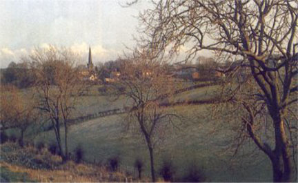
- (Start) Set off through the village, passing the green and St Mary’s church, with its spire. Go down the lane past the turn for Glebe Farm and look out for a stile on the right.
 Cross this stile and head down into Cow Dale. At a junction of dales cross a stile, then a little further cross another, to the right of a large tree. This takes you into Oxlands Dale with its wooded slopes. Cross this stile and head down into Cow Dale. At a junction of dales cross a stile, then a little further cross another, to the right of a large tree. This takes you into Oxlands Dale with its wooded slopes.
- (2.4km, 1˝ miles) Walk up the valley, climbing steadily round into Shortlands Dale and up to a copse by Foxcovert Farm. Turn right along the farm track to reach a minor road. Cross slightly left to follow a field-side path (SP) past some trees. The path keeps to the field-side, swinging east along a ridge. In summer this rolling landscape will be one expanse of golden corn. After about 1km (ľ mile) you come to a tarmac farm road climbing out of Aunhamdale.
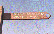
- (4.8km, 3miles) Turn right and walk down this track to meet the Tibthorpe road at Freshlands. Cross straight over and continue due south along a grassy field edge path. After passing a belt of woodland you come to a T-junction with a broad green lane. This is the Harwold Bridle Road. Turn right and walk along this bridleway for about 400m, where you bear left down another green lane between hedgerows. This brings you down to the North Dalton road.(For the shorter walk continue ahead along the Bridle Road)
- (7.0km, 4Ľ miles) Cross straight over the North Dalton Road to join a concrete farm road. You can now stride out down this road, passing the remaining barns of what was once Tithe Top Farm. At a crossing of tracks turn right (SP Minster Way) and pass a barn and a dewpond before arriving at a junction with another farm road. Turn right past a small copse down to the barns and white house at Blanche Farm. Continue past the farm to meet the South Dalton road again.
- (11.2km, 7 miles) Turn left and walk along the road, towards Huggate, for about 400m. Then bear left again (SP Minster Way) rejoining the Hawold Bridle Road. As you stride along this green lane (at about 160m above sea level) there are extensive views south across the Wolds. After 2km (about 1˝ miles) the lane dips down to a metal gate and another road. Turn right here and walk along this road back into Huggate. (15km, 9˝miles)
Along the Way
Huggate is the highest village on the Yorkshire Wolds at 170m (550ft) above sea level. On the village green is the site of a well, which at 365ft, is said to be one of the deepest in England. Unusually for the Wolds there is also a pond, situated on a bed of clay overlying the chalk.
Today’s walkers and riders have much to thank the Enclosure Act of 1795 for, which stated that the Hawold Bridle Road should be a ‘bridleway for all time’.
Arnold Underwood (Dec 2004, updated Aug 2020)
|