|
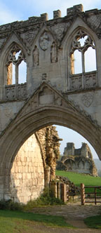
NORTH YORKSHIRE - Kirkham Priory
England's Heritage in the Howardian Hills
This is a pleasant walk in the Howardian Hills Area of Outstanding Natural Beauty ľ a fact proclaimed on the many signposts. This circuit uses parts of the clearly signed Centenary Way and Ebor Way, as well as some less well-used field paths, which will test your route-finding skills.
Fact File
|
Distance
|
16.8km/10Ż miles
|
|
Time
|
4Ż hours
|
|
Map
|
OS Explorer 300, Howardian Hills and Malton
|
|
Start/Parking
|
Roadside near Kirkham Priory (Grid Ref: SE735658)
English Heritage have imposed a ú4 parking charge (free for EH members) at the parking area by Kirkham Priory
|
|
Terrain
|
Undulating field paths and woodland bridleways with some marshy areas.
|
Grade
|
*** moderate
|
|
nearest Town
|
Malton
|
|
Refreshments
|
Pub in Welburn (slightly off-route), and the Stonetrough Inn, Kirkham
|
|
Toilets |
None
|
|
Public Transport
|
Yorkshire Coastliner (840/2/3 Leeds ľ Whitby/Scarborough) operates along the A64. Other local buses serve the area from Malton and various weekdays
|
|
Suitable for
|
allľ but take great care at the two crossings of the A64, and the railway
|
|
Stiles
|
5
|
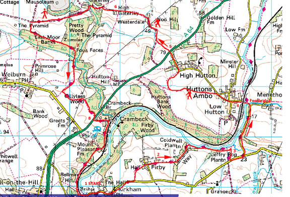
Image produced from the Ordnance Survey Get-a-map service.
Image reproduced with kind permission of Ordnance Survey and Ordnance Survey of Northern Ireland.

NOTE : The section from Firby along by the river is currently closed by North Yorkshire County Council, whilst maintenance of the riverside path is undertaken. A diversion via the road is advised by the Council. It is possible to get along the path by the river, but you do so at your own risk. The board-walk across the boggy sections has been removed, presumably prior to reconstruction.(Oct 2005)
- (Start) Walk up the road away from the Priory, turning left just before the Stonetrough Inn. In a about another 400m take a footpath left (SP Firby) straight across a field, then right to a stile in the corner. Continue across the next field to a gate into the grounds of Firby Hall. Pass through, coming to another gate and walk down the driveway to the road in Firby village. (You will probably be escorted by friendly barking dogs at Firby Hall) Turn right along the road then left at the next lane (CW sign).
- (2.5km, 1Ż miles) Walk along the lane passing High Farm, after which the lane becomes a tractor track to the end of a belt of woodland. The map shows the path going left through the trees, but this is not possible. Turn left and walk down the far (east) side of the woodland belt. In the corner you will come across a waymark confirm your path down through the trees to the bank of the River Derwent. Turn right and follow the river upstream for 800m. The going can be tricky as it is likely to be wet underfoot, and although some sections are board-walked these can be slippery. Things get worse before they get better because you now enter an area officially described as bog! Jeffrey Bog Plantation is a nature reserve and with its waterlogged ground and fallen trees presents something of an obstacle course. Your best route is to skirt well to the right, away from the river, swinging back towards the river to exit the plantation at the far corner.
- (5km, 3 miles) Walk, by the river, along the bottom of the next field to a footpath sign and broken stile in the next hedge. Do not cross, because although a faint path continues it is not the right of way. You must turn right up the field to a road ľ as you top the rise you should see a footpath sign ahead at the roadside. Back on the tarmac, go left along the road for 200m taking the left fork towards Merebeck (CW sign). Walk down this lane to once again come close to the river (passing a stile where the unofficial path, for anglers only, emerges). Where the road goes to the right take the footpath left down to the riverbank and along to where a substantial suspension footbridge crosses the river. Walk steadily over the bridge to avoid excessive oscillations!
- (8km, 5 miles) Cross a small anglers car park and go through the arch under the railway. Head up hill though Low Hutton, passing the war memorial and red phone box, towards High Hutton. By Grange Farm bear left along a track (bridleway, SP Hutton Hill). In 800m go right onto a field side footpath (SP High Hutton ľ no horses). Walk round the field edge into High Hutton to rejoin the road. Turn left up to its junction with the busy A64 York to Scarborough road.
- (9.8km, 6 miles) With great care, cross over the road to the bridleway directly opposite. Walk down the fields passing through gates to join the farm road leading up to the white-painted house at Westerdale. Go left behind the house following a track along a field side. About halfway along the field go right at a gap in the hedge (fallen SP) and continue along the other side of the hedge. Go round the field corner and up the side by the hedge to find a footbridge. Cross this and head towards the buildings at High Gateley, joining a farm road.
- (12km, 7Ż miles) As you walk along this lane past High Gateley, the Mausoleum in the parkland at Castle Howard can be seen over the trees directly ahead. You lose sight of it as the track dips down and round by Low Gateley. The track becomes a metalled lane as it climbs up past a conifer plantation and foresters cottages. Ahead, the ĹPyramidĺ comes into view with a glimpse of Castle Howard itself in the distance. The Mausoleum is again in view to your right, together with New River Bridge and the Temple beyond that, but at the next intersection of tracks you must turn left, heading back into woodland. Here a sign offers a choice ľ straight on or left. Unless you want visit the inn at Welburn, turn left to follow a broad track along the edge of the wood. At a footpath sign you will need to bear right as indicated, but before doing so venture onward a few yards into a clearing where you will find the Four Faces Monument. This is actually a good spot for lunch, particularly if you need shelter from the weather.
- (13.5km, 8Żmiles) Retrace you steps to the main path and turn to head down through the trees to a gate and stile. Ignore a path to the right and continue along the edge of the wood and up a field side to a metal gate. Through the gate, signposts mark the intersection of several paths ľ take the track straight ahead towards Welburn (bridleway ľ blue waymark). Over a slight rise you will see Welburn village over the fields on your right. At the next junction (SP Crambeck) turn left. (If you have taken the detour via Welburn this is where you rejoin this route). It can be muddy at first but conditions should improve as the track skirts round Chantry Hill. Head straight across the field, passing under power lines, to a corner of a wood. Go through a gate and walk along the edge of the wood to the main A64 road. Go right a few yards to a bus stop, then cross the road. Again taken great care here.
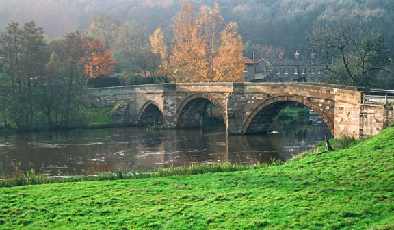
- (15km, 9Żmiles) Walk into Crambeck village and find a footpath sign on the right. Follow this through a gap in a hedge and continue past tennis courts and some exclusive properties. When it appears that you are about to enter the driveway of the last house, swing right through a gateway and walk down the side to a gate in the corner. Turn to follow the path along the top of a wooded bank with the River Derwent and the railway down below. A little further the path descends steeply to a lane. Cross over(SP Kirkham) and continue through more woodland, which eventually gives way to open pasture. Follow the track across fields through open gateways towards the buildings at Kirkham. You have a choice of routes- either go diagonally across to the bottom corner of the field, over a stile, and down a steep bank (take care) to the road and then over level-crossing , or go left over a concrete stile (SP Centenary Way) and cross the tracks (take care) to another stile and turn right through gates past cottages and Station House to reach the road. Go back over Kirkham Bridge to the Priory (16.8km/10Żmiles)
Along the Way
Castle Howard, with its immense fašade, is one of Englandĺs grandest and best-known houses. Designed by Sir John Vanbrugh and built between in 1699 and 1726, for the 3rd Earl of Carlisle, it has remained the home of the Howard family for 300 years.
Kirkham Priory was a house of Augustinian canons, communities of priests who observed the Rule of St Augustine and who took responsibility for parish churches early in their history. The Priory is now in the care of English Heritage, and is open to the public from Easter to the end of October.See English Heritage/Kirkham Priory for full details.
Note: Unfortunately there is no longer a tea-room and small garden centre at the former Station House at Kirkham.
Arnold Underwood & Denise Middleton (Oct 2004), & HWC (Oct 2005)
|