
|
NORTH YORKSHIRE: Kirkham
History & Natural History
This walk takes you through some of the rolling Yorkshire countryside of the Howardian Hills AONB that borders Yorkshire's River Derwent. There are views towards Castle Howard itself and across the Derwent valley, plus a ruined priory to explore at the end of the walk.
Fact File
|
Distance
|
14.0km (8ū miles)
|
|
Time
|
4― hours
|
|
Map
|
OS Explorer 300 (Howardian Hills & Malton)
|
|
Start/Parking
|
Kirkham Priory, grid ref: SE 734658. Limited parking near the Priory or at the roadside.
|
|
Terrain
|
This is a moderate walk through rolling countryside using field & woodland paths and tracks, riverbank, and country lanes.
The section through Jeffry Bog Nature Reserve can, surprisingly, be boggy! After excessive rain this section may have to be avoided altogether by returning to the road as far as Firby.
|
Grade
|
*** (moderate)
|
|
Nearest Town
|
Malton
|
|
Refreshments
|
Pub in Kirkham (The Stone Trough), refreshment kiosk at Kirkham Priory
|
|
Toilets |
None
|
|
Public Transport
|
Yorkshire Coastliner buses York - Malton - Scarborough (840/843) operate regularly along the A64, providing an alternative start and finish at Crambeck bus stops.
|
|
Suitable for
|
everyone, but extreme care is needed crossing the busy A64 road, so not ideal for young children or dogs
|
|
Stiles
|
8
|
Route created using TrackLogs Digital Mapping
Image reproduced with kind permission of Ordnance Survey and Ordnance Survey of Northern Ireland.

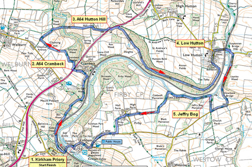
- (Start) Walk down the road and cross the ancient narrow bridge over the River Derwent. Just over level crossing, new steps on the right access a footpath across the fields parallel with the railway. (A path which once crossed the tracks east of former station has been closed). Continue through Kirkham Valley from field to field parallel with railway and river, to reach a lane. Down to your right is the former Castle Howard station, now holiday accommodation. Cross the lane and climb up through woods. Turn left and walk past tennis courts into Crambeck village. Go up the village road to its junction with the A64.
- (2.4km/1―miles). Taking extreme care, cross to bus stop opposite and walk down the verge and escape the traffic by taking footpath on the left. This path skirts the edge of woodland and cuts across Chanting Hill beneath pylons to meet a track where you turn right. In a further 200m you reach a convergence of paths where you bear right. A narrow path leads to a boardwalk down over boggy ground into the valley of Cram Beck. Go into woods and cross footbridge over the beck. Plod up steep hillside under pylon to reach Hutton Hill Farm. Ignore the first signpost and continue ahead into farmyard. A faded sign on a barn wall directs you to the right, past buildings and down driveway back to the A64. Walk down to a lay-by.
- (4.8km/3miles). Once again, cross this busy road with extreme care to reach a grassy bank opposite. Keeping on the bank, away from the traffic, make your way up to top of hill. Go through the gate and take the right-hand track down hill with wide views across the vale. Enter woodland and the footpath leaves the main track to continue ahead to a secluded cottage. Beyond the cottage climb through trees to rejoin the track. On leaving the woods, the walk contours along hillside overlooking the River Derwent to gate in corner by more woodland. Follow the track up by trees and round to cottages in Low Hutton.
- (8.2km/5miles). Walk down the street to green and turn right downhill. Pass under railway bridge and cross river by foot suspension bridge. Turn right and come to a country lane. Walk along lane for 1.5km to T-junction, turn right on to busier road for 400m. Opposite Church Farm turn right down a track towards river. Continue down field-side, where you are likely to encounter cattle, to find a Jeffry Bog information board near the river bank.
- (10.4km/6―miles). Turn left and follow footpath through the bog a boardwalk is provided in places (If the bog is waterlogged you may have to return to the road). Leave the bog and continue in the company of the river through rough grazing to a field gate. Do not go through but turn left up field side and climb up through trees. Walk up by trees to a farm track and turn right to Firby. Turn right then left to find a footpath up side of the garden of Firby Hall, through gates into a field (cattle or sheep). Cross the stile opposite and go left round field sides to a stile onto a road. Walk along road down to Kirkham, turning right at the T-junction for the Priory.

Along the Way
Don't miss the opportunity to visit Kirkham Priory. The ruins of this Augustinian Priory are in the care of English Heritage, and are open to the public on weekends in the winter months and on additional days through the summer. For more information see the English Heritage website: www.english-heritage.org.uk
Arnold Underwood & Suzanne Watson (Aug 2013)
|
