|
NORTH YORKSHIRE - The Northern Fringe of the Yorkshire Wolds
As featured in Country Walking Nov 2008
Leavening Brow
Explore the northern fringe of the Yorkshire Wolds via the tiny hilltop church at Burythorpe and quiet estate village of Birdsall. From the top of the Wolds escarpment - the brow - there are extensive views across Ryedale towards Castle Howard and Sutton Bank
Fact File
|
Distance
|
12.5km/8 miles |
|
Time
|
4 hours
|
|
Grade
|
** moderate
|
|
Map
|
OS Explorer 300(Howardian Hills & Malton)
|
|
Start/Parking
|
Leavening Brow picnic site (Grid. Ref: SE 793 632)
|
|
Terrain
|
Field paths, bridle-ways, and minor roads.
|
|
nearest Town
|
Malton
|
|
Refreshments
|
Pubs at Leavening (The Jolly Farmers) and Burythorpe (The Bay Horse) |
|
Toilets |
none
|
|
Public Transport
|
None of use to walkers |
|
Suitable for
|
everyone.
|
|
Stiles
|
8
|
- (Start) From the small car park walk down the hill into Leavening. Follow the main street through the village, passing the pub on the left. About 100m beyond the last house, a metal gate on the right opens onto a track leading up to Mount Pleasant Farm. This gate may be locked (as a security measure safeguarding the ponies in the paddocks) so cross over the stile to left of the gate and join the farm track via another gate a short distance beyond.
- (1.5km, 1mile) Walk up the hill towards another gate. There is a stile to the right, but is obscured by bushes - a fact I didn't discover until after climbing the gate. Continue up the field side, over another stile to reach the edge of woodland at the field corner. A track goes down the side of this wood - in the care of the Woodland Trust - towards High Penhowe Farm. Just before the gateway cut left to the corner where you will find a stile. Cross and go left, over another stile, and follow a well-signed route around the perimeter of the farm.
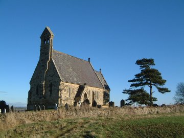
- (2.8km, 1ľ miles) After this deviation the path turns along a field side which curves round past trees to a gate in the corner. From there drop down across a paddock crossing another stile to join the farm road from Low Penhowe. Walk down to the T-junction with a minor road and there turn right. Walk along this narrow lane (beware of farm traffic) past woodland and up past Aldmoor Farm to another road junction. Note that, as you top the rise by Aldmoor Farm, the bell tower of Burythorpe Church appears on the skyline. Turn left along the road for a few yards then right through a gate to follow the field-side bridleway to the church. When approached from this direction the tiny church appears to be in the middle of nowhere on its hilltop.
- (4km, 2˝miles) From the church walk down the lane into Burythorpe. At the crossroads continue straight on, towards Birdsall. In about Ľ mile, at the second bend, take the track (FP sign) left towards the Hermitage. Follow this track round towards the houses then bear left round the outside perimeter. Pick up a tractor track heading across fields towards woodland. Do not enter the wood but turn left by the trees along the field side. In the corner the path cuts through to a stile, crossing a boggy area where a stream springs from the hillside. Cross an overgrown wet area to another stile, then head across the field to come alongside Coombe Wood. However another very boggy area may well require you to deviate well into the middle of the field. At the end of the wood continue diagonally left across the field to come alongside the hedge, eventually arriving at a gate. From the gate a track leads past Birdsall Grange to a road junction.
- (7.5km, 4˝miles) Turn right up the lane, overhung by trees, to reach the parkland setting in the centre of Birdsall. The imposing church is to your left and Birdsall House is straight ahead. In the middle of the green you must turn left, over the cattle grid to rejoin the road by Home Farm. Continue along the road with Birdsall House across the parkland on your right. Turn right along the lane for Burythorpe, passing the Manor. At a bend, turn left onto a narrow lane leading, in about ľ mile, to Mount Ferrant Farm.
- (9.6km, 6 miles) At the farm, swing left uphill away from the house past barns. At a bridle gate enter the field on the left and head diagonally up the boggy hillside through another gate. As you plod uphill a marker on a post comes into view and you pick up a faint track leading up to a gate. Maintain direction beyond the gate, keeping below and to the right of old quarry workings and you will eventually encounter a track coming up the hillside from Burythorpe. Go through the gate and turn left up the track to reach the road, almost opposite the carpark. Spend a few minutes taking in the panoramic view - you can pick out much of the route of the walk from here (12.5km/8miles)
Along the Way
Birdsall is a typically English estate village, home of the 12th Baron Middleton, of the Willoughby family. For 300 years the family has managed the estate through a balanced mix of traditional rural values and the best agricultural practices, so that the estate may thrive for future generations to enjoy. Visits to the House and Estate can be arranged by contacting the estate office.
At Burythorpe, surprisingly The Bay Horse public house is older than the quaint church - the inn is about 250 years old, but All Saints church was built in 1858, replacing an earlier Norman building.
Near to Mount Ferrant farm is the site of a 12th century Motte & Bailey castle.
The car park and picnic site on Leavening Brow are on the site of a former rubbish tip!
Arnold Underwood & Caroline Gowthorpe (Oct & Nov 2003) Minor revisions Dec 2008.
|