| Linear Walks on the North York Moors | |
|---|
| Lion Inn to Hutton le Hole | Lion Inn to Danby Moors Centre |
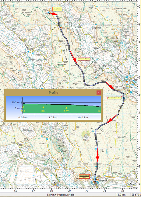
Lion Inn>Rosedale Railway>Bank Top>Hutton-le-Hole
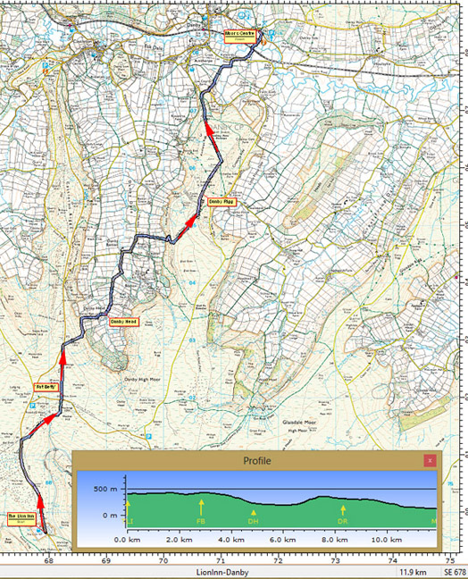
(8˝ miles/4 hours) | Lion Inn>Fat Betty >Danby Head>Danby Rigg>Moors Centre
(7˝ miles/4 hours) |
| Bus set down Blakey (Lion Inn) ; Return from Hutton-le-Hole | Bus set down Blakey (Lion Inn); Return from Danby (Moors Centre) |
Downhill all the way - with great views across Rosedale from the old Ironstone railway.
Not happy with moorland crossing after Rosedale Bank Top? Then continue alongside the minor road back to Hutton | The route can be tricky around Danby Head and across Danby Rigg.
Save time? Ask the driver to drop you off 1 mile north of the Lion Inn at the road junction by Young Ralph Cross |
 |  |
| Circular Walks | |
|---|
| Lion Inn to Lastingham/Lower Askew | Pickering - Howl Dale |
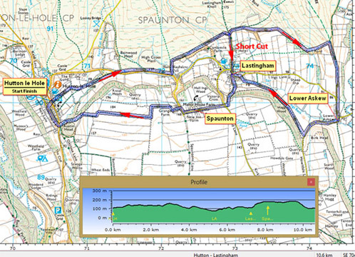
Hutton le Hole>Lower Askew>Lastingham>Spaunton>Hutton
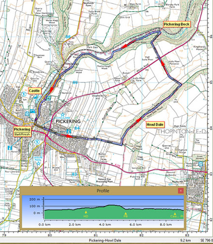
(7 miles/3 hours) | Pickering>Howl Dale>Newbridge>Pickering Castle
(6 miles/3 hours) |
| Bus set down Hutton-le-Hole; Return from Hutton-le-Hole | Bus set down Pickering (Ropery); Return from Pickering (Ropery) |
| Time to spare? Visit the Ryedale Folk Museum in Hutton le Hole and the historic St Mary's Church in Lastingham. | Time to spare? Visit the Beck Isle Museum, the Castle, or the NYMR Station in Pickering. |
 |  |
| More ideas for Linear Walks on the Moors | |
|---|
| Kirkbymoorside to Hutton-le-Hole (short) | Kirkbymoorside to Hutton-le-Hole (long) |
Kirkbymoorside>Gillamoor>Hutton-le-Hole
(5 miles/2 hours) | Kirkbymoorside>Kirkdale>Gillamoor>Hutton-le-Hole
(8 miles/4 hours) |
| Bus set down Kirkbymoorside ; Return from Hutton-le-Hole | Bus set down Kirkbymoorside ; Return from Hutton-le-Hole |
| More ideas for Circular Walks on the Moors | |
|---|
| Kirkbymoorside via Kirkdale & Gillamoor | Lion Inn - Upper Rosedale |
Kirkbymoorside>Kirkdale>Fadmoor>Gillamoor>Kirkbymoorside
(8˝ miles/4 hours) | Lion Inn - Rosedale Railway trackbed round Upper Rosedale>Dale Head Farm (Tea Garden)>Lion Inn
(6 miles/3 hours) |
| Bus set down Kirkbymoorside; Return from Kirkbymoorside | Bus set down Lion Inn; Return from Lion Inn |
| Discover the Yorkshire Wolds Way | |
|---|
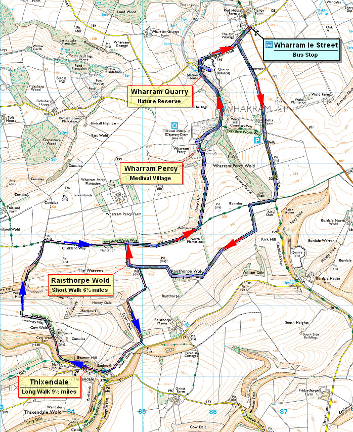
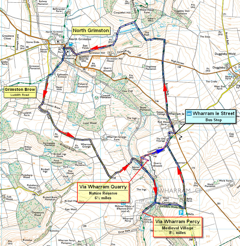
| Via Wharram Percy 'Lost' Medieval Village | Wharram le Street & North Grimston |
Wharram le Street via Centenary to Raisthorpe Wold.
Return on the Wolds Way via Wharram Percy
(6˝ miles/3 hours)
Can be extended via Thixendale (9˝ miles/4˝ hours)
For route map click here:
Via Wharram Percy Route | Wharram le Street via Wolds Way to North Grimston.
Return via Luddith Road over Grimston Brow via Wharram Quarry (Nature Reserve) or Wharram Percy (Medieval Village Site)
(6 or 8 miles/3 or 4 hours)
For route map click here:
Via North Grimston Route |
| Bus set down Wharram le Street; Return from Wharram le Street | Bus set down Wharram le Street; Return from Wharram le Street |
| Other ideas for Circular Walks on the Yorkshire Wolds | |
|---|
| North Grimston & Settrington | Bainton to North Dalton |
North Grimston>Settrington>Settrington Beacon>Wolds Way>Wood House>North Grimston
(8˝ miles/4 hours) | Bainton>Minster Way>North Dalton>Tithe Top Farm (long)>Deep Dale>Wolds Village Tearoom>Bainton
(6˝ or long 9˝ miles/3 or 4˝ hours) |
| Bus set down North Grimston; Return from North Grimston | Bus set down Bainton; Return from Bainton |
