
|
LINCOLNSHIRE WOLDS - Nettleton - (16.0km, 10miles)
'Viking Ways'
The Lincolnshire Wolds south of Caistor are blessed with a network of footpaths, bridleways, country lanes, and access land making it ideal walking country. This walk passes the highest point in Lincolnshire at 168m (551ft) above sea level. From the ridge there are extensive views all round. Surprisingly, up until 1968, this rural landscape near Nettleton was the setting for the intensive mining of iron ore, and the evidence for this is passed on this walk. Full details and route maps are displayed at the small car park near Nettleton.
Fact File
|
Distance
|
16.8km (10Ẅ miles)
|
|
Terrain
|
field paths, farm tracks and minor roads
|
|
Time
|
5 hours
|
|
Stiles
|
10
|
|
Grading
|
*** moderate/strenuous
|
|
Suitable for
|
keen walkers
|
|
Start/Parking
|
Ramblers car park 1 mile out of Nettleton village (Grid Ref: TF 111 991)
|
|
nearest Town
|
Caistor and Market Rasen
|
|
Refreshments
|
None on route. Nearest - Salutation Arms (Nettleton), Caistor Top tearooms
|
|
Toilets |
none
|
|
Public Transport
|
Interconnect service 3 bus (Lincoln Grimsby) serves Caistor and Nettleton (hourly, not Sundays). Call Connect service 3C, links the surrounding villages from Caistor.
|
|
Map
|
OS Explorer 282 (Lincolnshire Wolds North)
|
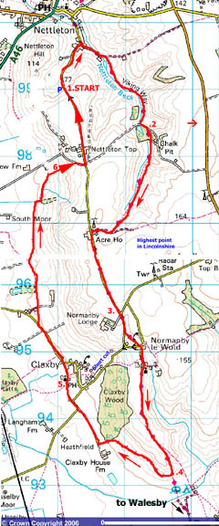
Image reproduced with kind permission of Ordnance Survey and Ordnance Survey of Northern Ireland.

The outward leg of this walk follows the Viking Way. Look out for this logo on signposts - 
- (Start) From the car park turn left and walk back down the hill towards Nettleton. Immediately on reaching the village turn right along a lane (SP Viking way) to Grange Farm holiday cottages. At the end of the lane go through gate into field and turn right (footpath sign) it can be very muddy here due to cattle. Walk up the valley from field to field with Nettleton Beck to your right picking the best route to avoid muddy sections. Eventually you reach a track where you turn left up the hill.
- (2.4km, 1Ẅmiles) A footpath sign directs you right, through trees, into the heart of the former ironstone mining area. You pass some bricked-up tunnels in the hillside, before the path drops down through the trees into open country. Behind you is the closed off entrance to a tunnel through which the path original passed. Continue up the valley following the Viking Way, which eventually climbs steadily up to the top of the dale. Turn right and walk along field side to the Claxby Road. Here, turn left and walk along this minor road, which keeps to the ridge for about 1.5km (1 mile). On a clear day there are extensive views south towards Lincoln. You are now very close to the highest point in Lincolnshire (551ft), which is across the field on your left near to a radar golf ball station.
- (5.6km, 3Ẅmiles) At a junction continue straight on as the lane dips downhill towards Claxby (You could cut the walk short here by dropping down to Claxby to join the return leg). About 200m (220yds) from the junction a sign post points the way left along the top of a field (probably containing cattle) to the hamlet of Normanby le Wold. Turn left along the road, then right at the junction. This narrow lane leads to the church, which is some way from the centre of this village. Here the tarmac ends and the route continues as a bridleway towards Walesby. There are views east across a rolling landscape who said Lincolnshire was flat! Keep to the main path (Viking Way) as it starts to descend the end of the ridge. The village of Walesby lies ahead with the Ramblers Church just visible on the hill beyond. However we do not visit Walesby today. As you near the hedgerow at the bottom of the hill look out for a footpath sign pointing right alongside this hedge.
- (8.8km, 5Ẅmiles) Here you leave the Viking Way and double back to follow the hedge along the bottom of the hill it is very wet and muddy, caused by a combination of cattle and water springing from the hillside. After an unpleasant 10mins negotiating this morass you reach a gate and a clear farm track beyond. (Red waymark). It is now a pleasant walk along fringe of the Lincolnshires Wolds with flat arable land on your left and the Wolds escarpment rising to your right. Here, the bottom edge of the hillside is blanketed by scrubby woodland, which leads eventually to the more extensive Claxby Wood. At the corner of the wood bear left down the track, to meet a farm lane near Claxby House Farm. Turn right along this lane to meet the Claxby Road. Continue straight on towards Claxby, but at the next bend leave the road to follow a permissive path (footpath sign path may not be shown on the OS map) straight ahead through a field towards Claxby Church. This church, like others in the area, is built of the local ironstone. Part of the churchyard, described as Gods Acre, is set aside for wild flora and fauna. A seat by the church provides for a useful lunch stop.
- (11.2km, 7miles) Continue along the lane from the church to join a minor road leaving Claxby. Once clear of the village, near the Viking Centre bunkhouse, the road narrows to a single-track lane. Walk along here for about 800m (Ẅ mile), passing an interesting antiques centre. Easily missed as you stride along this quiet lane is a signpost on the right pointing straight across a field. Fortunately the soil in these parts is quite sandy and drains well so even after rain it doesnt cling to your boots too much. Across the field climb a bank and keep by the hedge on your left near some sheds this is pig-farming country. At the next field, paths fork you need to follow the right fork, the footpath straight across, probably through crops depending on the time of year. After this, the walking improves as the path keeps along the field sides new gates, and footbridges being recent improvements to this right of way.
- (14.4km, 9miles) Just before a remote cottage, turn right up a permiisive path up the hillside. This brings you to a track leading to the road at Nettleton Top. Turn left and walk along the road down the hill to the car park (16.0km/10miles)

Along the Way
The Viking Centre at Claxby was opened in 1982 in the old village school, a development sponsored by West Lindsey Silver Jubilee Association. Major refurbishment work was carried out in early 1999 after the centre had been awarded a grant of £68,000 by the National Lotteries Charities Board.
The Viking Way is a 150 mile long distance path extending from Oakham, in Rutland through Lincolnshire to the Humber Bridge at Barton-upon-Humber. The name Viking Way, originally suggested by the Ramblers' Association, is intended to reflect the influence of Danelaw imposed by the Norse invaders in this part of England.
Arnold Underwood with Hornsea Walking Club (May 2006)
Revised 2014 due to expiry of Permissive Access agreements on Nettleton Hill
|
