
|
EAST YORKSHIRE û Millington 14.5km (9 miles)
Over the Wolds to Nunburnholme
Start the New Year with a brisk stroll on the Yorkshire Wolds, with this route linking the villages of Millington and Nunburnholme
Fact File
|
Distance
|
14.5km/9miles
|
|
Terrain
|
Minor roads, field paths and bridleways
|
|
Time
|
4 hours
|
|
Stiles
|
5
|
|
Grading
|
*** Moderate
|
|
Suitable for
|
all û but take care along country roads
|
|
Start/Parking
|
Millington Church. Grid Ref. SE 875591 |
|
Nearest Town
|
Pocklington
|
|
Refreshments
|
Ramblers tearoom & the Gait Inn at Millington.
World Peace CafÚ at Kilnwick Percy Hall (see below)
|
|
Toilets |
none
|
|
Public Transport
|
East Yorkshire Buses 45,46, X46 & X47 from Bridlington/Hull/York, operate via Pocklington.
|
|
Map
|
OS Explorer 294, Market Weighton & Southern Yorkshire Wolds
|

Route created using TrackLogs Digital Mapping
Image reproduced with kind permission of Ordnance Survey and Ordnance Survey of Northern Ireland.

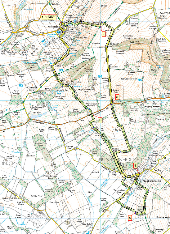
- (Start) At the road junction, just past the church, turn down into the village. In about 100m look out for a signpost on the left. Walk down a driveway and bear right down a flagstone path passing a house and grounds undergoing restoration work. Cross footbridge & stile into field (horses). Head straight up the bank (can be muddy) to join a track heading up towards Warren Farm. Continue straight up the hillside by way of gates or stiles to meet the Wolds Way at the top of the hill.
- (1.2km/ ¥ mile) Turn left, passing Warren Farm (with its peacocks), and walk round the corner. Had straight up the track to meet a minor road. Turn right and walk down this road for about a mile to its junction with the B1246. On the way note a trig point on the left situated on a tumulus mound. This is the highest point of todayÆs walk û 204m above sea level.
- (3.6km/2╝miles) At the road junction cut down the bank to cross the B1246 (take care û fast traffic). Straight across, follow the footpath into a belt of woodland û this is particularly delightful in spring with primroses, wild garlic, and bluebells. The path twists and turns through the wood to eventually emerge in an open field. Turn right alongside the hedge to meet the Wolds Way at a signpost. Turn left and walk downhill on a stony track through more woodland (Brant Wood) to meet a minor road. Bear left into Nunburnholme (ignore the WW SP on right)
- (6.4km/4miles) At the road junction in the village double back right along Church Lane. In about 50m take the footpath on the left along a tractor track but do not follow this into the ford, but fork left across a wet field to a footbridge over the beck. Now head straight up the squelchy hillside passing a stile in a non-existent fence, to reach the top of the field and there turn right. There are good views back over Nunburnholme towards the Wolds. Walk along the field side past Thorn Wood. Cross a stile on the right and head downhill by the wood and round the corner û this sheltered corner may provide an ideal spot for a break.
- (8.0km/5miles) Head down the field with hedge on your left to a footbridge taking you back over Nunburnholme Beck. Continue to the road and turn right towards St James' Church (worth a visit). Just before the church turn left (SP Wolds Way, Wilberforce Way) along the field side round to another road. Turn left then soon fork right to follow the Wolds Way back up through Brant Wood. You are retracing the outward leg here, but the hill seems much steeper going up than down. Continue ahead on the Wolds Way past where the outward route joined. At a farm, although an obvious track goes straight ahead, the right-of-way forks left past buildings and joins a metalled farm road. In about 400m just before a solitary house turn right (footpath sign) up the field side past an extensive brick garage. At the top turn left along a track (which appears to be a continuation of the one diverted from at the farm) to meet the B1246 again on Kilnwick Percy Hill.
- ( 11.2km/7miles) Cross the road again with care. Note Kilnwick Percy Hall down to the left. Walk along the contours to Warrendale Farm which from this direction appears rather derelict with rusting farm machinery, crumbling buildings etc. Go through a gate into the yard and bear left past cattle sheds and the house, to another gate. Head along the farm road, which twists in and out of Warren Dale and arrive at a road junction. Here the Wilberforce Way goes left, and the Wolds Way goes right; but our route goes straight on down the lane towards Millington. At the bottom the lane swings left over a beck and up into the village. Turn right and walk through the village passing the Gait Inn and the tearoom and turn left up to the church and your car. (ItÆs only a short stroll back to tearoom or pub after changing your boots!) (14.5km/9miles)
Along the Way
Kilnwick Percy

Based in the Georgian mansion of Kilnwick Percy Hall, Madhyamaka Centre is a thriving Buddhist meditation centre. It was founded in 1983 by Geshe Kelsang Gyatso, and it is one of the largest and most well established Buddhist Centres in the UK. The centre provides meditation teachings, courses and retreats to people from all walks of life.
Drop in to Madhyamaka Centre's World Peace CafÚ at Kilnwick Percy Hall and try our delicious vegeterian meals and yummy cakes. ThereÆs acres of woodland and parkland to explore after your visit to the cafÚ.

Opening times: Daily 10.30am - 4.30pm (Closed over Christmas)
If you would like to visit the cafÚ with a group of 6 or more people, please ring or email in advance to ensure we can fit you in and feed you!
Email worldpeacecafe@madhyamaka.org.
For full information and menu visit the website at
World Peace Cafe
Wiberforce Way
The Wilberforce Way is a 60 mile linear trail devised to mark the bicentenary of the 1807 Act of Parliament abolishing British involvement in the Transatlantic Slave Trade. The trail starts in Hull (where William Wilberforce was born), goes through Pocklington (where he went to school) and finishes in York (where he was declared MP for the County of Yorkshire)
Arnold Underwood (April 2008; Updated Dec 2013)
|
