
|
East Yorkshire – Pocklington to Market Weighton 15.0km (9˝miles)
'Wolds Linear Walk'
This is a linear walk from Pocklington to Market Weighton and makes use of the excellent bus service between these two market towns. The walk passes through the grounds of Kilnwick Percy Hall, now a Buddhist Madhyamaka Centre – a haven for peace and meditation. Access is permitted to the grounds, and the route takes you through the parkland and past the lake, linking existing rights of way.
Other points of interest on the route are three village churches, the site of Londesborough Hall, the lost village of Towthorpe, and the Giant Bradley trail in Market Weighton.
Bird watchers should keep a look out for buzzards and red kites soaring over the Wolds
Fact File
|
Distance
|
15.0km (9˝miles)
|
|
Terrain
|
An undulating route along the edge of the Yorkshire Wolds using field paths, bridleways and minor roads
|
|
Time
|
4˝ hours
|
|
Stiles
|
6
|
|
Grading
|
*** Moderate
|
|
Suitable for
|
all
|
|
Start/Parking
|
Market Weighton Market Place (Grid Ref: SE 876418) |
|
Nearest Towns
|
Pocklington and Market Weighton
|
|
Refreshments
|
Cafés and pubs in Pocklington and Market Weighton; World Peace Café at Kilnwick Percy Hall; Teas in Londesborough Reading Room on Snowdrop Sundays (Feb 2012)
|
|
Toilets |
In Pocklington and Market Weighton and at the World Peace Café, Kilnwick Percy
|
|
Public Transport
|
East Yorkshire buses 46 & X46/X47 link Market Weighton and Pocklington
|
|
Map
|
OS Explorer 294 (Market Weighton & the Yorkshire Wolds)
|

Route created using TrackLogs Digital Mapping
Image reproduced with kind permission of Ordnance Survey and Ordnance Survey of Northern Ireland.

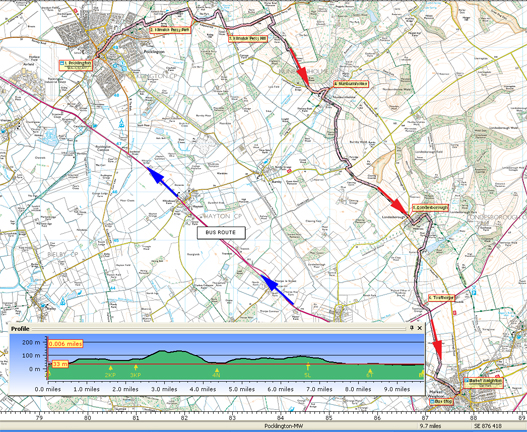
- (Start) Catch the bus to Pocklington from the bus stop next to the Giant Bradley statue in Market Weighton High Street. The journey takes about 15mins. Alight in Pocklington by the bus depot.
Cross the road from the bus-stop and walk into Pocklington town centre. From Market Place head north cutting along the narrow Union Street to pick up the B1246 Kilnwick Road heading out of town. Walk along the left-hand pavement and branch left into Target Lane. After crossing Denison Road the lane continues as a track up Chapel Hill to a transmitter mast at the top. Turn right here and then left along a narrow path by hedgerow alongside the golf course. When the path emerges from trees, maintain direction across the golf course towards Kilnwick Percy, following occasional marker posts. Notice new holiday chalets and the impressive Clubhouse up to your left. Cross the golf course access driveway to reach the Kilnwick Percy road. Turn right and walk down to the entrance to Kilnwick Percy Hall.
- (2.5km/1˝ miles) Climb a stile to the right of the gateway to gain access to the parkland. Head down the bank towards the lake to another stile and a footpath round the south side of the lake. Clearance work has opened up views across the lake towards Kilnwick Percy Hall and church. At the far end of the lake, the path crosses a stream and another stile to re-enter the park. The World Peace café is straight ahead to the right of the Hall. However, the walk follows the stream along to the corner of the park, just down from the church. Here, pick up a public footpath over the stile by the gate and head up hill. Follow the sides of fields to emerge on the B1246 road at the bottom of Kilnwick Percy Hill.
- (3.6km/2Ľ miles). Turn left and walk up the road. Beware of fast traffic, particularly as you approach a slight bend near the top. Pass the entrance to a farm and at top of hill come to footpath sign. Here, turn right to follow the Yorkshire Wolds Way (YWW) along the field side and then right again down to a house. Turn left along the farm road, and walk past the buildings at Wold Farm to a gate. Continue ahead down the field to a join a farm track which leads down through Bratt Wood to a road. Turn left and walk down the road to Nunburnholme (ignore YWW going right). On the green there is a seat, so a good place for a break, but the village has no other facilities.
- (6.8km/4Ľ miles) Turn acutely right to head out of the village towards the church. Take the second footpath left, rejoining the YWW. Walk past a farm and keep left to cross a footbridge over a beck and head up the hillside to a gate at the top corner. Turn right following the YWW along the ridge, passing Thorns Wood. Keep along edge of fields to Partridge Hall and then along the farm road to its junction. Turn right along minor road towards Pocklington then left towards Londesborough. There is no alternative to about 1.5km of road walking – but there is little traffic and there are extensive views west across the Vale of York. On the roadside you will come across an information board explaining the view.
- (10.4km/6˝miles) At Londesborough follow the road straight into the village and round the corner towards the church. Just beyond the church is a gateway into the grounds of the original Hall, demolished in 1818. These grounds are opened for a few days in February for the Snowdrop Festival. Continue along the road and bear right along the driveway through trees into Londesborough Park. Keep to the main drive across the park to the lodge and gates. At the road go left for about 50m then take the footpath into fields on the right. Keep on a tractor track along edge of fields through gates and past the site of the ‘lost village’ of Towthorpe.
- (13.2km/8Ľ miles) Walk past Towthorpe Grange and along the drive to the main A614 road. Cross straight over – take care – busy and fast traffic. Follow footpath along field sides and then straight across the last field, which can be rather sticky! A kissing gate brings you out by houses on the edge of Market Weighton. Turn left and walk along the roadside pavement back into the centre of town.
Along the Way
Market Weighton
Giant William Bradley, the local celebrity, was born in Market Weighton in 1787 and is on record as being the tallest man to have lived in the UK, at 7ft 9in. The Heritage Trail created by the Market Weighton Civic Society consists of 23 granite footprints around the town, to the exact size of Giant Bradley's shoe size. The trail gives visitors an opportunity to see the wealth of Georgian and Victorian buildings in the town.

Londesborough Snowdrop Sundays - February
Visit the picturesque village of Londesborough and enjoy the beautiful snowdrops whilst strolling round parts of Londesborough Estate private grounds that are only open for the Snowdrop Sundays.
Arnold Underwood (Feb 2012)
|
