|
NORTH YORKSHIRE MOORS - Helmsley
Round by Rievaulx
This is a walk of contrasts - setting off along the well-walked Cleveland Way to the magnificent ruins of Rievaulx Abbey - there will be plenty of folk about at any time of the year. After this tourist honey-pot you will be then lucky to meet anyone for the next few miles. The return leg takes you through quite dense woodland before descending into secluded Beck Dale to follow Borough Beck down to Helmsley.
Fact File
|
Distance
|
15.5km/9˝ miles |
|
Time
|
4Ľ hours
|
|
Grade
|
*** (quite strenuous)
|
|
Map
|
OS Explorer OL 26 (North York Moors West)
|
|
Parking
|
Roadside parking in Helmsley or long-stay car park near Helmsley Castle. (Note the Market Square is for 'short-stay' parking only)
|
|
Start
|
Helmsley Market Square, grid ref SE 613838
|
|
Terrain
|
Woodland paths (some indistinct), tracks and country lanes, with a couple of steep climbs
|
|
Nearest Town
|
Helmsley
|
|
Refreshments
|
At Rievaulx Abbey Visitor Centre (restricted opening in winter), plus plenty of pubs and cafés in Helmsley
|
|
Toilets |
Helmsley, Rievaulx Abbey (restricted opening in winter)
|
|
Public Transport
|
Scarborough & District 128 from Scarborough (Not Sundays in winter), TransDev York service 31X from York via Easingwold (not Suns), Moorsbus from the surrounding area (Sundays & BH April to Oct)
|
|
Suitable for
|
for all (take care with children and dogs on the busy road)
|
|
Stiles
|
none
|
Route created using TrackLogs Digital Mapping
Image reproduced with kind permission of Ordnance Survey and Ordnance Survey of Northern Ireland.

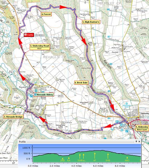
- (Start) From the market square, head north towards the Church, cross over the Stokesley road (B1257) and follow the Cleveland Way up the lane past the main car park, with the castle ruins to your left. You will be following the clearly signed Cleveland Way National Trail as far as Rievaulx Bridge. Initially this heads up the side of four fields before turning left then right along the top edge of woodland. Into the woodland, the path dips down then up to cross a gully and then emerges by a lodge cottage with views down Ryedale towards Duncombe Park. Continue into woodland once more, ignoring any other paths and nature trails. The Way bears left, descending the wooded hillside to a minor road. Turn left and walk down the road to Rievaulx Bridge.
- (4.5km, 2ľ miles) Turn right and walk along the road to Rievaulx Abbey. There are toilets and an English Heritage information centre and gift shop here, but you will not have time to visit the Abbey today. With views of the impressive ruins to your right continue on through the village and up the hill. Almost opposite the church turn left along a narrow lane. Do not lose height - keep right at forks in the track. Woodland gives way to views up Ryedale. At a diagonal intersection of tracks cross straight over to head up and round into open farmland. The track continues alongside a wall to the Stokesley Road (B1257)
- (7.5km, 4˝ miles) Cross over and turn left. You must now walk along this fast road for about 800m (˝ mile). As far as the Hawnby turn there is plenty of verge, but not for the final 200m (220yds) to the gateway to Oscar Park Farm. Take care on this stretch - make yourself clearly visible to oncoming traffic, particularly the motorcyclists that roar along this road at weekends. With relief, turn along the farm track to pass through Oscar Park Farm. The track swings right to cross a dip and up the other side. Bear left alongside a fence to arrive at a gate in the corner. Continue along the side of the next field to another gate leading into extensive woodland.
- (9.8km, 6 miles) You are now somewhat off the beaten track and footpaths here can be indistinct. Continue forward from the gate along a rutted track, which can be wet and muddy in places. After about 400m (Ľ mile) this track swings left out of the dense woodland to meet another track along a shallow valley. Turn sharp right here, and, in about 100m (110yds) look out for a way-mark on the left indicating a narrow path heading up into the trees. This faint path picks its way through the trees in an easterly direction. Look out for yellow markers pinned to the trees. Felled timber and anthills present obstacles but continue the easterly trend, to reach and cross a forest track. The land starts to fall away and the path descends gradually before bearing left and becoming steeper. A sharp right continues the zigzag descent into the depths of a narrow gorge. This is a fascinating place with the bottom of the gorge strewn with moss-covered boulders. The sun rarely penetrates the steep wooded sides so this little valley is cool, dark and damp but only after excessive rain is there running water. From here the only way is up - not as steep as the descent but a steady climb - to the top of the eastern side of the valley.
- (11.2km, 7 miles) Take a break at the top, before continuing due south on a clear path along the edge of the woodland with a steep drop down to your right. Eventually the path descends into a small side valley, and this is followed down to reach the floor of the main valley. This has widened from the narrow gorge crossed earlier and there is also running water - the infant Borough Beck. Now route finding is easy - you just have to follow the beck down to Helmsley. Occasionally the path crosses and re-crosses the stream and in about 1.2km (1 mile) you come to fenced-off pheasant rearing enclosure. Here birds are bred for shooting but by late summer the enclosure gates will be open and the whole area will be swarming with young pheasants. If the gates are open, walk straight through the enclosure, if closed you will have to skirt to the left around it.
- (13km/ 8 miles)At a clearing, fork left continuing down-stream, after which the track becomes surfaced with stone - not ideal for walking. After passing a sawmill, the track becomes a metalled road on towards Helmsley. You can leave the tarmac by taking to a path on the right, alongside the beck, which brings you out on to the Stokesley road. Finally walk down the road back to the centre of Helmsley (15.5km, 9˝miles)
Along the Way
Helmsley is a major centre for the surrounding area. A variety of shops, inns, cafes and restaurants border the Market Square. It has much to offer the visitor - the ruined 13th Century Castle, an 18th Century Walled Garden and Duncombe Park, home of the Earls of Feversham.
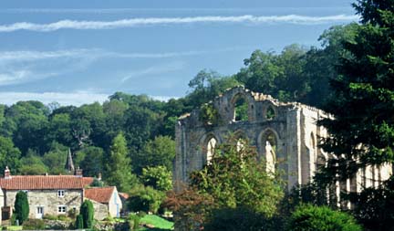
Rievaulx Abbey is, without doubt, one of the country's finest ecclesiastical ruins. This Cistercian Monastery was founded in the 12th century, and the roofless shell that stands today still cannot fail to impress.
Arnold Underwood/Bob Cutts/HWC (Oct 2003)
|