
|
North Yorkshire - Ripley
'Nidderdale Way'
This is a varied walk that includes riverside, farmland and woodland sections. Starting from the delightful village of Ripley with its Castle and deer park, the walk follows parts of the Nidderdale Way via Hampsthwaite and Shaw Mills.
Fact File
|
Distance
|
16km (10 miles)
|
|
Time
|
4Ẅ hours
|
|
Map
|
OS Explorer 298 (Nidderdale)
|
|
Start/Parking
|
Ripley Car Park
|
|
Terrain
|
Field & riverside paths, bridleways, & minor roads
|
|
nearest Town
|
Knaresborough
|
|
Refreshments
|
Pubs at Ripley, Hampsthwaite and Birstwith, Tearoom at Ripley Castle
|
|
Toilets |
Ripley
|
|
Public Transport
|
Harrogate & District 36 Leeds - Harrogate Ripley Ripon, 24 Harrogate Hampsthwaite Pateley Bridge; Hutchinsons 23 Harrogate Ripley Shaw Mills
|
|
Suitable for
|
all (with dogs on leads through farmland)
|
|
Stiles
|
15
|

Route created using TrackLogs Digital Mapping
Image reproduced with kind permission of Ordnance Survey and Ordnance Survey of Northern Ireland.

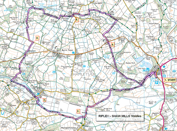
- (Start) From the car park walk into the village and turn left to follow the Nidderdale Way past the entrance to the Castle. Through a gateway the track dips down to bridge Ripley Beck by a weir. Here there is a view back across the lake to the Castle. The route follows the boundary wall of Ripley Park, and in places you can se over the wall and may be able spot deer in the park. Where the wall goes right, continue straight on passing pockets of woodland. Just as you join a metalled lane go left down another track (bridleway). Follow this for about Ẅ mile to where it joins the road from Clint. Continue down the road (care no footpath) to reach a few houses. Hereabouts there was once a station on the Pateley Bridge railway line closed back in the 1960s. The only evidence now, being a stone bridge abutment at the corner. Walk on by the road to cross the ancient bridge over the Nidd into Hampsthwaite.
- (3.2km/2 miles) We dont venture far into Hampsthwaite! Turn right through the lych-gate into the churchyard and walk past the church and exit the graveyard by a gate in the wall. The path brings you out onto the Birstwith road. Walk along this road (care no footpath) for a 400m (ỳ mile). Just past a barn, a new gate gives access to a field and the riverside. Now back on the Nidderdale Way, the river is followed to Birstwith through a succession of new gates. Look out for kingfishers, dippers, and heron along this stretch. The tranquil riverside setting is rudely interrupted as you near Birstwith where a large food processing mill looms up. Footpaths are diverted round the site with the Nidderdale Way going right towards the river and skirting the northern perimeter of the factory to bring you out on the road near the river bridge. A pub (The Old Station Hotel), which welcomes walkers, is in the village, over the bridge.
- (5.2km/3ỳ miles) Unfortunately it may be too early in the day to visit the pub! So cross straight over the road and pick up a narrow path through nettles to continue by the river for another 800m (Ẅ mile). Then, through the trees, you get a glimpse of the graceful arched bridge known as New Bridge. This bridge appears to be on an old packhorse route that crosses the river here. Turn right over the bridge, cross the track-bed of the old railway, and climb steadily away from the river. The enclosed track leads to open field. Go up the left-hand side of this field to a metal gate (ignoring footpath sign left). Through the gate you resume the upward trend along the enclosed lane. Where the climb levels out, you join the driveway from Dinmore House then meet the B6165 road. Cross with care to the gate opposite (ignoring footpath slightly to the left) and continue along the bridleway. This in turn reaches a minor road, where a large boulder is positioned to deter unauthorised access to the bridleway.
- (8.0km/5 miles) Turn left along the road, then right along the lane to High Winsley Farm. Continue past the turn to the farm to reach High Winsley Cottage and other properties converted from former farm buildings. Go between the buildings through a gate and downhill into rough pasture. There is a lack of direction signs now, but continue down towards Thornton Beck (hidden by trees) and bearing right along the bottom of the field. You come to a Nidderdale Way sign by a footbridge. Do not cross the bridge (currently closed due to flood damage) but continue along bottom of the fields until a marker indicates that the bridleway climbs up the bank to the top corner. Go through gates, following the track along the top of fields (made messy by cattle) to reach a lane near some cottages. Turn left down and then right following the lane past the huge Cow Gate Manor Barn. Across the valley can be seen High Mill, partly in ruin. The lane comes down to Shaw Mills where there is an extensive new housing development. At the road turn left over the bridge. There are a few seats dotted around which could make this a choice for a lunch break. Alas the pub here closed in 1994!
- (10.8km/6ẅ miles) Continue through the village and where the road bears left look for a concealed footpath in the corner. This cuts through a garden between garage and house and into a field. Follow the edge of the field along to a corner but do not cross a stile; instead turn left up the field then right, to keep on the Nidderdale Way. Hereabouts the route becomes confusing it should be straightforward following the Nidderdale Way, but it isnt! The bridleway descends and enters a large sloping field with woodland along the top. Bear left to pick up a rough track leading up to High Kettle Spring farm, ignoring a footpath left. Walk past the buildings along a very messy farm track to find a small gate on the right. Go through and follow the path down through the trees to Low Kettle Spring. Near the buildings there should be a path through the field on the right aiming for Bedlam. There is no sign, but a little further along, just past a pig shed there is a green arrow on a gate into this field. Go through and walk straight down the field (cattle) to find, just round a corner, a footbridge across the beck. Cross the bridge and bear right (hidden waymark on tree stump) and walk the up field sides, keeping left of the hedge and fence until the last field. At the road turn left and walk down to the T-junction in Bedlam.
- (13.6km/8Ẅ miles) Across the road to the left, the footpath continues through a wrought iron pedestrian side gate down the side of a large house into a paddock. Walk down the sides of three fields, although stiles are missing in a couple of places. At the bottom of a dip with woodland on the right there is an intersection of footpaths. Go through the gateway and continue straight up the next field to converge with the boundary wall of Ripley Park. This wall is now followed most of the way back to Ripley. At a corner, a plaque on the wall describes the Monks Cross, which is just visible in the trees over the wall. As you swing down towards Ripley you may again get glimpses of deer in the park, before rejoining the outward route for final 800m (Ẅ mile) back to the Castle and car park. (16km/10 miles)

Along the Way
Do not depart without exploring the delights of the village, with its antique shops, cafés, and the Castle. The old stocks still stand in the cobbled market square.
Ripley Castle has been the home of the Ingilby family since 1320. In 1644 the Ingilbys supported the Royalists in the Civil War but were defeated by Oliver Cromwells army at the battle of Marston Moor. When Cromwell sought shelter for the night at Ripley Castle, William Ingilby, fearing for his life, hid in a secret chamber. However, Williams sister Jane Trooper Jane stood guard over Cromwell with two pistols.
This fact is commemorated by a local beer, Daleside Brewerys Crack Shot Ale, available in the Castle delicatessen and the Boars Head Hotel.
Arnold Underwood (Oct 2007)
|
