|
NORTH YORK MOORS - Robin Hood's Bay
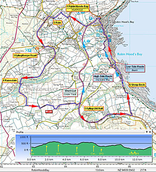
Round by Ramsdale
Heading inland with fine views across the Bay. After Fyling Hall and the restored watermill at Ramsdale return to the sea at Stoupe Brow. If the tide is out continue along the beach, otherwise follow the clifftop Cleveland Way by way of Boggle Hole, back to 'Bay Town' and fish & chips.
As featured in Country Walking magazine - June 2008
Fact File
|
Distance
|
13.6km/8˝ miles
|
|
Time
|
4 hours
|
|
Maps
|
OS Explorer OL27, North York Moors (East)
|
|
Start/Parking
|
Limited street parking by Church. Main car park (old station) pay-and-display, grid ref NZ 950054
|
|
Terrain
|
Undulating field paths & bridleways, disused railway. If you hope to walk back along the beach, check the tide times before setting off.
|
Grade
|
*** moderate
|
|
nearest Town
|
Whitby
|
|
Refreshments
|
Pubs, cafés and excellent fish & chips in Robin Hoods Bay
|
|
Toilets |
At start/finish
|
|
Public Transport
|
Arriva 93/93A Scarborough – Whitby (daily)
|
|
Suitable for
|
all
|
|
Stiles
|
8
|

Route created using TrackLogs Digital Mapping
Image reproduced with kind permission of Ordnance Survey and Ordnance Survey of Northern Ireland.

- (Start) Head south out of the car park, passing the old station building, and turn right up Thorpe Road. Where the road turns left, go up steps (footpath sign) in the corner to a stile leading into a field. Walk up the edge of a series of narrow fields, crossing about 8 stiles in the process! At the top you arrive on Church Lane, where you turn left and then, in about 50m (50yds) turn right up a farm track. This narrows to become a sunken green lane, which can be wet underfoot. When this lane swings right another lane merges from the left. Double back up this track under some large trees. In places along this track ancient flagstones are evident. Between the trees the view across the Bay opens out after which you come upon a gate leading into a garden with a well manicured lawn. Press on regardless passing outbuildings and joining the driveway past the house up to the road. Here a sign confirms that you were on a right-of-way!
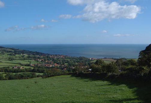
- (2.4km, 1˝ miles) Turn right up the road (steep hill) through Raw. At the top, about 50m (50yds) past a turn on the right, a footpath sign points the way, left, along a track. There now follows an airy walk along the fringe of the moor between a mix of gorse and bracken. Evidence of former quarrying pock-marks the landscape on your right, but to compensate there is the complete panorama of Robin Hoods Bay on your left. Ignore other tracks to left or right and follow the contour round the hillside. After crossing the track to Skerry Hall, the way ahead becomes more overgrown, put press on and things improve as the track curves round to meet a road.
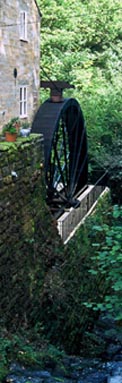
- (4km, 3 miles) This road is the main access to Fylingthorpe and Robin Hood's Bay from the south, and can be quite busy. Crossing to face oncoming traffic, walk downhill for about 100m (100yds) and take the right fork towards Fyling Hall. Continue along this lane through the gateway (Fyling Hall School) and at the fork by the school, take to stony track on the right (bridleway sign). This track contours round the hillside, before dropping down into the wooded Ramsdale. The track twists and turns, with the beck down to your left, to arrive at the restored Ramsdale Mill. If you are lucky the restored water wheel may be operating.
- (6km, 4miles) Cross the bridge behind the Mill and walk up towards Mill Farm. There turn sharp right through a gate. Follow the field side (can be wet) up and round into Carr Wood. At the top of the wood turn left (bridleway sign) into open fields. Turn right through a gate then left to continue due east by a crumbling wall and gorse bushes. In the next field (usually containing cattle), swing right to follow the tractor track down and round to Swallow Head Farm. Go through the farmyard and down the lane to reach a minor road. Turn right and follow the road round the corner to where it was once crossed by the railway line. (For those wanting a shorter walk, going left here along the old track 'Cinder Path' will bring you unerringly back to Robin Hoods Bay).
- (7km, 5 miles) Otherwise join the old track bed on the right and follow the Cinder Path towards Ravenscar. Initially the route passes through woodland and under a couple of bridges. Then Stoupe Brow rises on your right above Browside Farm, whilst on the left the land falls away and there is an uninterrupted view of the full extent of Robin Hood's Bay. Pass under the Stoupe Brow road and immediately turn left to join the road. Walk down the road to its end by Stoupe Bank Farm. Descend Stoupe Bank (steep steps) and cross the bridge over the beck.
- (10km, 6˝ miles) If the tide is in, or coming in, you must use the cliff path (Cleveland Way) up the steps and over to Boggle Hole, and up and over again to Robin Hoods Bay. If the tide is out walk down to the beach and have an easy stroll back along the beach to Robin Hood's Bay. You will have to negotiate Mill Beck as it spills across the beach at Boggle Hole, having flowed down from Ramsdale. If need be, the cliff-top path (Cleveland Way) can be rejoined at Boggle Hole. Along this stretch of beach you may encounter some strange sights – lamas, with parties of walkers taking it easy ‘lama trekking’, and other, more weary, walkers dipping there boots in the sea after completing Wainwright's ‘Coast to Coast walk’. At the Bay Hotel have a drink in the Wainwright Bar, or a cup of tea in one of the cafés, and don’t forget the fish and chips! Also don't forget that your car, or the bus-stop, is up the hill!
(13.6km/8˝ miles)
Along the Way
Robin Hood's Bay is one of the prettiest fishing villages on the Yorkshire Coast. Its red pantile roofed houses cling to the cliffs around the ravine of Kings Beck. A very steep road links the old village, once the haunt of smugglers, with the more modern development at the top - which grew with the coming of the railway in 1885. Alas the railway is no more, but provides an excellent recreational path - the Cinder Path, and tourists have replaced smugglers as the main source of trade for the village.
The walk returns past Boggle Hole - A Boggle is a hobgoblin - they were thought to live in caves along the coast.
Arnold Underwood (Sept 2004, Updated Aug 2016)
|