|
NORTH YORKSHIRE MOORS - Roseberry Topping
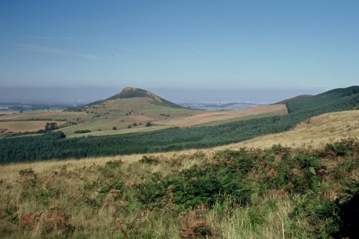
Roseberry Topping & Capt Cooks Monument
A classic walk over undulating heather moorland, taking in the distinctive conical hill of Roseberry Topping, the viewpoint at Highcliffe Nab, and the prominent monument to Captain Cook. By August the moors should be an expanse of purple heather.
Fact File
|
Distance
|
15.8km/9ľ miles (with options to shorten the route -see text) |
|
Time
|
4 hours
|
|
Grade
|
**** (strenuous)
|
|
Map
|
OS Explorer OL 26 (North York Moors West)
|
|
Start/Parking
|
Gribdale (grid ref NZ 592110)
|
|
Terrain
|
Field & moorland paths, tracks & minor roads
|
|
Nearest Town
|
Great Ayton, Stokesley
|
|
Refreshments
|
none (there may be an ice cream van at Gribdale in summer)
|
|
Toilets |
none
|
|
Public Transport
|
none, but Arriva NE service 81/781 serves Newton-under-Roseberry, from where you can climb Roseberry Topping to join the route at point 2.
|
|
Suitable for
|
strong walkers
|
|
Stiles
|
8
|
- (Start) For the first half of this walk you will be following the Cleveland Way. So from the carpark in Gribdale follow the Way due north steeply up the hillside onto Great Ayton Moor. The terrain levels out and you now have a pleasant undulating stroll for nearly 2 miles along the edge of the moor. To your right extends the expanse of moorland, best in late summer when the heather is in bloom. Near the path are ancient earthworks - evidence that our prehistoric ancestors made their home here. The escarpment on your left is wooded, but gaps allow views towards Great Ayton and Roseberry Topping.
- (3.5km/2miles) At a gate you must decide whether or not to visit this hill. Although it does involve a modest descent the climb is only 266ft compared with the 750ft of the direct ascent from Newton-under-Roseberry, so down you go. In the grassy hollow between the moor and this 'outlier', the hill rears up and seems much higher and steeper, but take the zig-zag path at your own pace and you will soon be rewarded by the all-round views. There is industrial Tees-side to the north (probably under a blanket of murk), Guisborough and the North Sea to the east, Captain Cook's monument to the south, and the continuation of the Cleveland escarpment across to the west.
- (4.5km, 2˝ miles) Now you must retrace you steps down and up back to the gate onto the moor. Paths radiate from this corner - you need to follow the wide track straight across the moor. This is the Cleveland Way, heading due east. The track dips down to a corner from which you continue along the edge of a plantation. At the meeting of another track go right through a gate and climb a little way onto the moor before swinging left. (The track straight ahead could be used as a short cut to the gates on Percy Cross Rigg at point 4). Continue on the well-worn path across Black Nab after which it dips to come alongside a wall below Highcliffe Farm. This area is surprisingly squelchy and your progress will be slowed as you pick your way through. Climb up alongside the wall to a gate at the corner of Highcliffe Wood. Another short detour through the gate, then forking right through the woods brings you to the craggy outcrop of Highcliffe Nab. This makes an excellent spot for a break with views over Guisborough to the Tees estuary.
- (7.8km, 4ľ miles) Return to the gate onto the moor. It's time to say farewell, for now, to the Cleveland Way and head almost due south on a clear track across the moor. After surmounting the gentle rise of Codhill Heights, green fields appear ahead. This is the remote valley of Sleddale. The track gently descends to meet a road leading to Sleddale Farm. Turn right up this road, which then dips to cross Sleddale Beck after which there is a steady pull up over the moor to a T-junction with the road along Percy Cross Rigg. Turn right and walk up the road for ˝ mile to a gate at the end of the tarmac. (This is where the 'short-cut' emerges)
- (11.2km, 7Ľmiles) Do not proceed straight ahead, but turn sharp left through another gate. This stony track descends by the western boundary of Lonsdale plantation to a junction with a minor road by some barns. (Turning right here provides another short-cut option as Gribdale car park is only about a mile along the road.) Walk straight ahead along the road through open country, over Lonsdale Beck and past Lonsdale Farm. You are now faced with another pull up through woodland onto the ridge. At the top you again meet the Cleveland Way, which has followed the road up from Kildale.
- (13.2km/8Ľmiles) So follow the Cleveland Way due west through woodland. Keep to the main path, which keeps more or less level, for about ľ mile at which point you are faced with another short climb up onto the plateau of Easby Moor. There a short distance ahead stands the 51ft high monument to Captain Cook. Although visible throughout earlier stages of the walk, it has latterly been hidden by trees until this point. The monument was erected in 1828 to commemorate the centenary of Cooks birth. It stands at this prime location, which, at 1063ft, is higher than Roseberry Topping. Once again there are views from the west round to the east - in fact you can trace a large proportion of this walk from Roseberry Topping and across the moors to Highcliffe Nab.
- (14.5km/ 9Ľmiles) You are now only just over ˝mile from Gribdale - so make sure you leave the monument in the right direction! You must head north from the monument across Easby Moor, then descend by steps and a stony track down through trees into Gribdale (15.8km/9ľmiles)
Along the Way
James Cook was born in 1728 in Marton on the outskirts of Middlesbrough. In 1736 the family moved to Airy Holme Farm, below Roseberry Topping, and James attended school in Great Ayton. After jobs as a farm hand and as an apprentice draper he went to sea working on North Sea colliers before joining the Royal Navy aged 27. He soon gained a great reputation as a navigator and charted the coasts of eastern Australia, New Zealand, and much of the South Pacific. In 1779 Captain James Cook was killed on the island of Hawaii. The full story is to be found on the cast-iron plaques on his monument.
The strange outline of Roseberry Topping has resulted from its unstable geology and the quarrying for jet and ironstone. Now in the care of the National Trust, much work is being done to limit a new form of erosion - caused by the attention of thousands of visitors every year.
Arnold Underwood/HWC (Sept 2003)
|