|
NORTH YORK MOORS - Rosedale - 14.5km (9miles)
'Seven Valley Circuit'
A fairly strenuous walk in the North York Moors National Park offering a variety of terrain and scenery. Field paths and moorland, forest and riverbank.
Fact File
|
Distance
|
14.5km (9 miles)
|
|
Terrain
|
Moorland, field paths and forest tracks & bridleways. Steep ascent and descent
|
|
Time
|
4¢ hours
|
|
Stiles
|
5
|
|
Grading
|
**** Moderate to strenuous
|
|
Suitable for
|
all û but can be rough going in one or two places!
|
|
Start/Parking
|
Car parks near Milburn Arms at Rosedale Abbey (grid.ref: SE 724 959) |
|
Nearest Town
|
Pickering
|
|
Refreshments
|
Pubs at Rosedale Abbey, Rosedale Bank, & Hartoft End. Tearooms at Rosedale Abbey
|
|
Toilets |
none on the route
|
|
Public Transport
|
Moorsbus M50 from Pickering (Sundays & Bank Hols, Easter û October, daily School Summer Holidays)
|
|
Map
|
OS Explorer OL27 North York Moors East
|
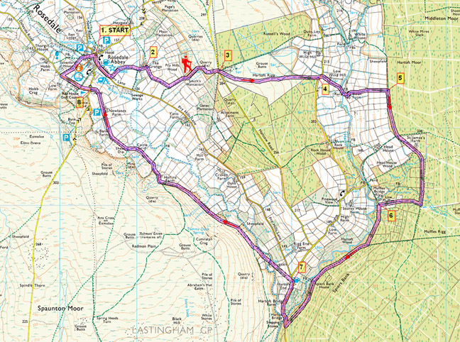

Route created using TrackLogs Digital Mapping
Image reproduced with kind permission of Ordnance Survey and Ordnance Survey of Northern Ireland.

- (Start) Head south out of the village along the roadside pavement. In about 400m (╝mile) take the footpath left (SP) up a farm track, past buildings and through a gate into fields. Head diagonally right across the field (or up and round the top if advised) to a gate in the corner. Walk along the edge of the next field to The Grange.
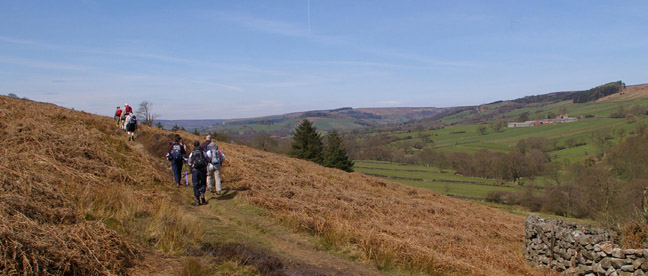
- (1.2km/¥ mile) Go left past the house and a holiday cottage to a gate on the right. Keep along the bottom edge of fields to a junction of footpaths. Turn left up the hillside, leaving pasture behind. In summer the next section gets overgrown with bracken. Pick your way uphill onto the moor. Thankfully the top of Hartoft Rigg is clad in heather and bilberry. There is a superb view back across the dale, with Ana cross just visible above the old ironstone workings, and further right the old kilns and cottages at Rosedale Bank Top. Head diagonally right across the moor to meet the Hancow Road at an information board by a gate/cattle grid.
- (3.2km/2 miles) Through the gate, take the bridleway right (south-east) across Hartoft Rigg. Initially a clear track across the moor, the path becomes more uneven as you drop down towards the corner of the forest on your right. At the corner, go through a gate and walk down the edge of the wood to a narrow minor road. Ahead, across the valley of Hartoft Beck, is the expanse of Cropton Forest on Hartoft Moor.
- (4.6km/3 miles) Turn left then right down to Birch Farm, crossing Hartoft Beck at a ford/bridge on the way. Walk through the farmyard to a gate to the right of the house. Head up the hillside towards the forest. The enclosed strip appears to be an old drove road. ItÆs a steady pull uphill, but nowhere near as bad as it looked from below. The top here by the forest is a good place to take a break.
- (5.6km/3¢ miles) Through the gate turn right (south) along a clear track skirting the forest edge. Cross a clearing, and pass St JamesÆ Farm, which is being renovated, to re-enter the forest, and continue south on the main forest track. About 800m south of St JamesÆ at a junction go right as indicated by a yellow post and arrow. Then immediately right again down a narrow path (a bridleway û no SP). This path, rather churned by horses, heads straight down through the trees to a gate and open fields. Here it is cattle which make the ground uneven! Walk down the side of the field to a gate and a track near the buildings at Low Muffles.
- (7.1km/4¢ miles) The bridleway marker points right here, but we turn left, through a gate and across the bottom of the next field, back into forest. You can now stride out as you follow this track for about 2km as it contours along Spiers Bank down to the valley road at Hartoft Bridge. Turn right up the road (take care û busy road) to arrive at the Blacksmiths Inn at Hartoft End.
- (9.6km/6 miles) Almost opposite the Blacksmiths Inn a footpath strikes off diagonally across fields down towards the river. After crossing a stile you come across the remote and seemingly inaccessible Scugdale Cottage. Behind the cottage a footbridge takes you over the River Seven. Head diagonally (north-east) across the field to a ladder stile among trees. After picking your way through more bracken the path joins the main track (bridleway) up the valley. Follow this track for 2km to Hollins Farm. From thereon the track becomes a rough, metalled lane serving the isolated farms along this side of the dale, eventually meeting the road at the White Horse Inn on Rosedale Bank.
- (13.4km/8╝ miles) There is now a choice of routes into the village, down the road or down one of two paths leading off Daleside Road, opposite. The second path is about 400m along Daleside Road. Take this path right, down fields to a footbridge over the river. Walk through the caravan park to the village, where the right of way cuts through the school playground, and past the church to the village green. Here there is a tearoom while the Milburn Arms, car park and toilets are just round the corner. (14.5km/9 miles)
Along the Way
RosedaleA century ago, the moors above the peaceful settlement of Rosedale Abbey were alive with industry. There was iron in 'them there hills'. The ore was dried in kilns and then taken by the Rosedale Ironstone Railway to iron works in Middlesbrough. There is evidence of mining and quarrying going on in the valley for hundreds of years previous. Then materials were transported along the rough valley road, which is the track followed on the return leg of this walk from Hartoft. Much of the medieval working was controlled by the Abbot of St. Mary's Abbey in York, which owned much of the valley. There was also a Cistercian Nunnery, of which very little evidence remains, in the village which may have had connections with the Abbey in York. 19th century building work revealed signs of a medieval iron works near to the nunnery site.
Today the major industries of this dale are farming, forestry, and tourism.
Arnold Underwood (Aug 2005, April 2007)
|