|
NORTH YORKSHIRE - Sheriff Hutton
'Howardian Edge'
From the attractive village of Sheriff Hutton, with its castle ruin, follow the Ebor Way onto the Howardian Hills, then pick up the Centenary Way via High Stittenham. The going can be muddy in places so a little frost to harden the ground could be desirable!
Fact File
|
Distance
|
11km (7 miles)
|
|
Time
|
allow up to 4 hours
|
|
Map
|
OS Explorer 300 Howardian Hills & Malton
|
|
Start/Parking
|
By the green in Sheriff Hutton
|
|
Terrain
|
Field paths, bridleways and minor roads
|
|
nearest Town
|
Malton
|
|
Refreshments
|
Pubs (The Highwayman and The Castle) in Sheriff Hutton
|
|
Toilets |
none
|
|
Public Transport
|
Stephenson's Bus service 180/1 York - Castle Howard (- Malton) serves Sheriff Hutton (Mon - Sat) (Subject to cuts in NYCC funding in April 2016)
|
|
Suitable for
|
all
|
|
Stiles
|
10
|
- (Start) From the centre of Sheriff Hutton, walk east past the Green towards the church. Keep on the road below and to the left of the church to reach a gate at the end. Go through the gate and past some barns, and then through a second gateway. Turn left (Ebor Way SP) and follow the field boundary round to a road. Turn right along the road.
- (1.2 km, miles) The Ebor Way actually continues through gates across the road, but that route is likely to be impassable because of deep mud. So walk on along the road for about Ľ mile, passing New House Farm, to the next gate on the left. Climb the stile by the gate and head north along a clear track. This track keeps to the right of stream, then turns and crosses it.
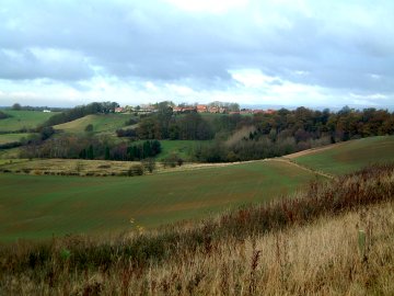
- (2.4 km, 3 miles) Here the line of the Ebor Way is rejoined. Continue along the track which heads straight for the ridge of the Howardian Hills. The easy going cannot continue and the good track ends at a bridge over a ditch. However maintain direction forward across the cultivated field to reach another ditch. Go over the bridge and turn left along the bottom of a field. Turn right past the hedge and head uphill to pass the disused buildings of Primrose Farm. The path then joins the driveway which is followed on up the hill. At the top there are good views back to Sheriff Hutton and also across towards Terrington.
- (4.5km, 3 miles) The track from Primrose Farm swings right and comes to T-junction with Mowthorpe Lane. Turn right and follow the lane for about 1 mile to Low Mowthorpe Farm. The track swings right past the farm, through a gate towards a small lake, popular with anglers. Leave the track and continue straight on into the paddock at the western end of the lake. On a fine day, this is a pleasant spot for a break.
- (5.5km, 3˝ miles) With your back to the lake, now following the Centenary Way, cross a stile by a gate and walk along the side of a small field to reach and cross another stile. Turn left and drop down the field side to cross Mowthorpe Bridge. Bear slighltly right and climb the hillside with an overgrown hedge on your left. As the gradient easies you pass through a gateway near the corner of a wood. Do not follow the track into the wood, but continue on up the field towards another gate and the buildings at High Stittenham.
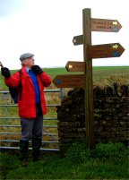
- (6.5km, 5 miles) Walk past the buildings to the road junction in High Stittenham. Note the footpath sign with arms pointing in all directions. Follow the direction (west) towards Sheriff Hutton. This follows a gravel track right then left past what was once Carr Farm. (All the builings here have been redeveloped as desirable residences). Go through the right-hand of two gates and follow the path downhill. The hillside here has been planted with young trees. A clear sign points the direct path, right, back to Sheriff Hutton, rejoining the outward route. For a longer alternative you should continue round the hillside plantation as indicated a by a non-to-obvious blue waymark. The going can be rough but persevere and you reach a gateway into open farmland.
- (7.5km, 5 miles) You must now walk straight acoss an expanse of cultivated land, aiming just right of the buildings on the hill ahead. Have faith and this will bring you first to a bridge over a drainage ditch and on up to a gap in the hedge by footpath sign. Cross over the road and go through two gates to the right of Wheatclose Farm and down the side of a field to another gate (note there may well be horses in this field). Continue by the side of the hedge and uphill, crossing a race-horse training gallops, towards Sheepclose Farm. Cross a stile by a gate to enter a field to the right of the farm. When adjacent to the buildings turn right to head due west down the middle of the field, aiming towards Sheriff Hutton.
- (8.5km, 5˝ miles) Maintain direction, with the Church as you target, across the next field and you will come to a footbridge over a ditch. Cross and continue up the fieldside to a sign and stile in the corner. Do not climb the stile, but turn right along the top of the field, soon coming to a footpath leading up into the church yard. Walk past the Church and back along the street past the green. Turn left at the signpost to view the castle and at the top of the driveway go through a gate to follow the castle perimeter walk. Leave via a gate by the west end of the ruins to emerge on the main road near to the village hall. Turn right to return to the centre of the village.
Along the Way
Sheriff Hutton is an attractive historic village situated midway between York and Malton. Its ruined castle, built in 1382 and currently undergoing restoration to prevent further decay, is a prominent landmark from miles around. St Helens Church dates from Norman times, and the medieval stocks are still in place on the village green.
The Howardian Hills are designated an Area of Outstanding Natural Beauty - a fact which is proclaimed on the many new footpath signs around Mowthorpe and High Stittenham.
Arnold Underwood (Dec 2002)
|