|
EAST YORKSHIRE - South Cave
As featured in Country Walking Magazine, Oct 1993
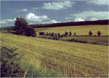
The southern fringe of the Yorkshire Wolds
A varied walk on the southern edge of the Yorkshire Wolds, taking in wooded dales and a disused railway line, with views across the River Humber.

Fact File
|
Distance
|
11.5km (7˝ miles) or 16km (10miles) via Everthorpe
|
|
Time
|
3˝ hours (4˝ hours)
|
|
Map
|
OS Explorer 293 (Kingston-upon-Hull & Beverley)
|
|
Start/Parking
|
Main Street in South Cave
|
|
Terrain
|
Field paths, tracks & minor roads
|
|
nearest Town
|
Beverley
|
|
Refreshments
|
Pubs, café and chip shop in South Cave. (Pubs & shop in North Cave) |
|
Toilets |
|
|
Public Transport
|
South Cave is served by buses 152 and 155 from Hull (daily) and 143 from Beverley (Mon, Wed, & Sat)
|
|
Suitable for
|
for everyone.
|
|
Stiles
|
4
|
- (Start) From the crossroads in the centre of South Cave set off east along the minor road towards Beverley. Turn left into Littlewold Lane. Once past the housing development the lane becomes an unsurfaced track bearing right up alongside Little Wold plantation. Your route is joined by the Wolds Way, which has come straight up the hillside. Continue along the edge of the woods passing two seats with views to the right across Cave Wold. The path joins a by-way along which you continue for about 300m until you come to a stile on the left (Wolds Way signpost).
- (2km, 1˝ miles) Cross the stile and walk down Combe Dale, following the Wolds Way. Bear right through a new bridle gate, and continue along the path, which has been re-routed to avoid subsidence of the bank. Drop down and cross the track-bed of the former Hull & Barnsley Railway where the old line enters a steep-sided chalk cutting, to join a track (Wolds Way SP) up into the trees.
- (3.5km, 2Ľ miles) Follow this clear path up through Low Hunsley plantation, bearing left at a junction. Note the old boundary stones at intervals on the left-hand side of the path. The path climbs more steeply as it nears the end of the dale to emerge on the edge of farmland. Follow the field boundary to the left round to the road. Here you say farewell to the Wolds Way, which heads right towards Newbald. You must now head left along the verge of the busy B1230 road - TAKE CARE here.
- (6km, 3ľ miles) In about 300m turn left through a gate onto a farm track. Follow this to a copse and go left, round the copse, and then right to join another track. This passes through another gate and descends the eastern side of Austin's Dale. Go through a gate to cross pasture, where there may be cattle, to another gate by a farm cottage. Follow the track from the cottage as it curves down to cross Drewton Beck and up to meet a lane. Turn right and walk along this lane, passing Drewton Manor, to arrive at the A1034 Market Weighton road.
For a longer walk - adding about 4km (2˝ miles), go right here then take the footpath left past Drewton Farm into North Cave. Return via the minor road to Everthorpe, and there take the footpath across fields into South Cave (West End)
- (8km, 5˝ miles) You must now walk along this road for about 1km (ľ mile) towards South Cave. The road has been improved at the site of the old railway bridge, improving visibility but traffic now moves faster. Cross with care to use the footpath on the other side of the road. You could keep along the pavement back into South Cave, but an interesting diversion is to cross a stile on the right just past a cemetery.
- (9km, 6 miles) The footpath is shown as heading straight across a golf course before turning left towards Cave Castle and the church. An alternative is to follow a stony path left towards a wood then by the trees alongside the golf course to meet the official right-of-way at a footpath sign just beyond farm buildings. Cross the stile by a gate to come to a lane past All Saints Church and the gatehouse to Cave Castle Hotel. Turn left along the road back to the centre of South Cave. There is a fine view over the wall of the Castle and its grounds. Back at the A1034 crossroads you will find various opportunities for refreshment.
Along the Way
South Cave is a market town, being granted its charter in 1291. The Market Hall in the High Street was built in 1796 to deal with thriving corn trade.
The Hull & Barnsley Railway linked the port of Hull with the South Yorkshire coalfield. The line closed completely in 1959. The tunnels at Drewton are now home to colonies of bats.
The name Drewton is apparently derived from 'Druids town' and St. Austin's stone was the centre for Druidical worship.
Arnold Underwood (Revised Jan 2006)
|