|
North York Moors - Square Corner 15.5km (9¥miles)
'Drovers Road'
Square Corner is a remote spot on the minor road heading south from Osmotherley across the Moors to Hawnby and Helmsley
This walk follows a fine section of the Hambleton Drove Road along the escarpment before descending to the twin villages of Nether and Over Silton. Climbing back up through woodland reveals extensive views north across Tees-side
Fact File
|
Distance
|
15.5km (9¥miles)
|
|
Terrain
|
A complete mix û moorland tracks, field and forest paths, minor roads. Some quite steep descents/ascents
|
|
Time
|
4¢ hours
|
|
Stiles
|
9
|
|
Grading
|
*** Moderate
|
|
Suitable for
|
all û but can be muddy in the forest
|
|
Start/Parking
|
Square Corner, 2miles from Osmotherley (grid. ref: SE479 959) |
|
Nearest Town
|
Northallerton
|
|
Refreshments
|
Pubs in Osmotherley 3.2km (2 miles): Pub in Nether Silton. (The Chequers Tearoom ¢ mile from Square Corner is now CLOSED)
|
|
Toilets |
None
|
|
Public Transport
|
Moorsbus M9 serves Square Corner (Sundays & BH March û Oct; also Wed July - Sept)
|
|
Map
|
OS OL26 North York Moors West
|
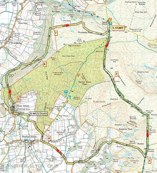

Route created using TrackLogs Digital Mapping
Image reproduced with kind permission of Ordnance Survey and Ordnance Survey of Northern Ireland.

- (Start) From the parking area head due south along a clear track heading towards the rounded Black Hambleton hill. With forest to your right the track rises steadily round the flank of the hill reaching a height of nearly 400m above sea level. Here views open out to the west across the Vale of Mowbray with the stepped outline of Pen Hill prominent in the far distance.
- (1.9km/1╝miles) You are now on the old Hambleton Drove Road, which follows the western edge of the moors south towards Sutton Bank. Today, mountain-bikers are more of a hazard to walkers than cattle, as many seem to hurtle along here with little regard for other users. The track makes a definite kink to cross White Gill Head. After a gate and cattle grid it continues its straight, undulating course along the edge above the villages of Silton and Kepwick. About ¢mile after White Gill, in a dip, a footpath (no cyclists) goes right through a gate in the wall. After the hazardous stony track along the top, this green path is a welcome relief.
- (4.7km/3miles) This path zigzags down the escarpment to join a farm track which crosses White Gill beck, here bordered with trees, and bluebells in spring. Walk along the track through gates past Nab Farm and down to a minor road. Turn right along this narrow road towards Nether Silton. In about half a mile turn left at a junction (thus avoiding Nether Silton).
- (8.7km/5¢miles) At the next bend a track goes off to the right into the forest û taking this will lead you straight back to the car park at Square Corner. Otherwise continue along the road towards Over Silton. Ahead the tiny St MaryÆs church comes into view, but as you near it you discover it is situated in its own walled churchyard in the middle of fields with no access other than by field footpaths. These paths cross the fields from the two Silton villages directly to the church. At a gate go right and walk along the side of the field to the church. From the church head across the undulating field to a stile/gate onto the road at Over Silton. Walk through the pretty village and at a left-hand bend continue straight on (SP Bridleway to Thimbleby).
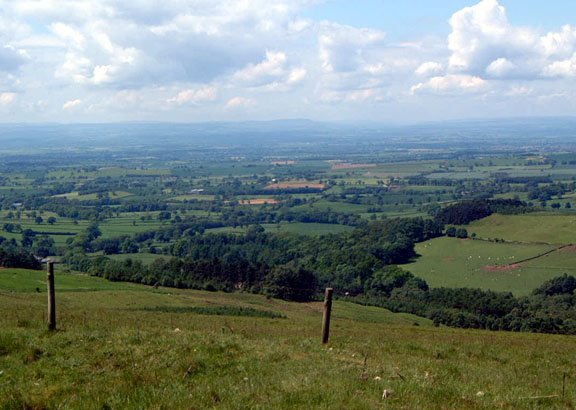
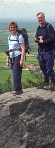
- (10.2km/6¢miles) At the start of forest the bridleway leaves the track to head left up through the trees. At the top this joins a broader track which is now followed along the edge of the forest gradually dropping down into more open woodland and to a gate. Here the bridleway goes left across fields to Thimbleby, but our way is to the right, along a footpath back into the forest. Initially on a broad track, at the top of the first section (waymark) the footpath strikes out on its own up through the trees. ItÆs a long steady climb, but the path enters more open land at the top of Thimbleby Bank and views across to Tees-side appear. However one last climb is necessary to reach the real viewpoint on a rock outcrop at the top.
- (12.3km/7¥miles) After taking in the view continue on the narrow path which soon enters dense conifer forest. Take care here, the path is narrow, at times muddy and criss-crossed with tree roots, and there is a steep drop left, down the wooded hillside! The path re-enters daylight and at a gate/stile you meet a stony track winding its way up through the trees from Thimbleby Hall towards the open moor on your right.
- (13.3km/8¢miles) Turn right along this track, ignoring the yellow waymark, and it will bring you onto Thimbleby Moor alongside a wall. Dead ahead, on the skyline, you should be able to see cars parked at Square Corner. The track initially aims unerringly towards them but then swings up to the right û this is to avoid a deep gully. Turning back left you eventually join the outward route about 100m from the car park. (15.5km/9¥miles)
Along the Way
Osmotherley
Taking its name from the Saxon prince Osmund, Osmotherley lies just a few miles from the Cleveland Hills and the picturesque Osmotherley Moor. It stands at the start of the challenging 40-mile Lyke Wake Walk to Ravenscar. John Wesley preached here by the townÆs cross. Nearby is the ruin of Mount Grace Priory, probably the best-preserved Carthusian house in England. Founded by Thomas Holland, Duke of Surrey, at the end of the 14th century, it was home to æsilentÆ monks who even avoided contact with each other.
The Hambleton Drove Road
The track is thought to be prehistoric but the large scale movement of cattle from Scotland and the north of England to Smithfield Market in London, gave it the name it is known by today. The drovers were nomads, travelling between 10 and 14 miles a day and some of their regular stopping places can still be located. The ruins of Limekiln House,which was once an inn, can be seen near the Cleveland Way, above Kepwick.
Cattle, sheep and pigs were all driven along the Drove Road, as were geese which were sometimes fitted with felt pads to protect their feet.
St. Mary's Church, Over Silton
This little church has no road access, but is situated in the fields between the present-day villages of Nether and Over Silton.
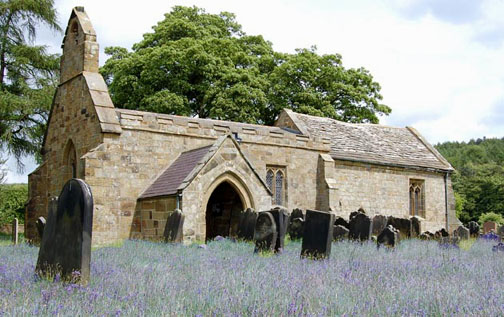 As for the village and what happened, we can only guess. The ôTerraceö to the west of the church is interesting and the configurations like a mill pond or fish pond in the field above the turning to Nether Silton and to the south of the present village of Over Silton, suggest that once a busy and prosperous population was to be found here.
Arnold Underwood (May 2007)
|