|
EAST YORKSHIRE - Stamford Bridge
As featured in the Nov 2007 issue of Country Walking Magazine
A TRAIL 'TWEEN TWO BRIDGES. Enjoy a peaceful stroll by way of field paths and woodland to Kexby Bridge, returning along the bank of the River Derwent, which here marks the western boundary of the East Riding of Yorkshire.
Fact File
|
Distance
|
16.8km/10˝ miles (can be shortened by using alternative bridleways east of Hagg Wood)
|
|
Time
|
4hours
|
|
Map
|
OS Explorer 295, York (Note Stamford Bridge itself is on Explorer map 294, but apart from a short section at the start and finish, this entire walk is covered by map 295)
|
|
Start/Parking
|
Stamford Bridge, carpark grid ref: SE 712555. (Alternative start: Kexby Bridge, parking by the old bridge)
|
|
Terrain
|
Field paths, farm tracks & minor roads. Can be muddy in places.
|
Grade
|
** easy
|
|
nearest Town
|
York
|
|
Refreshments
|
Pubs & café in Stamford Bridge. Pub in Low Catton
|
|
Toilets |
Stamford Bridge
|
|
Public Transport
|
Stamford Bridge served by First York service 10 from York (frequent) and East Yorkshire services to Pocklington (infrequent). Kexby Bridge is served by frequent East Yorkshire services X46/X47 and 744/6 Hull/Bridlington - Pocklington - York.
|
|
Suitable for
|
all– but take great care walking by the busy A1079
|
|
Stiles
|
4
|
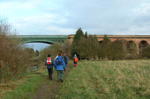
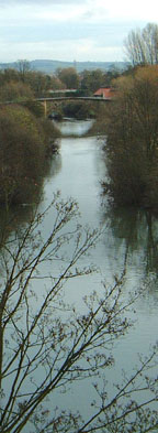
- (Start) This walk starts with a loop to gain access to the former railway viaduct, which has recently been restored to carry a public path. Walk out of the car park and turn right into a housing estate. Turn right again and follow the road round through the estate to a T-junction. Turn right again and in about 100m you come to the old railway station, now a youth centre. Turn right onto the recently resurfaced track-bed and pass between the platforms of the old station. Negotiate a barrier and you emerge on to the old railway viaduct high above the River Derwent. From here there is a view up river to the road bridge and the hills beyond. Further on the path drops down from the embankment to join the pavement alongside the A166 York Road.
- (1.5km/ 1 mile) This path is part of the National Cycle Network, route 66 and has been resurfaced and widened for that role. It skirts away from the traffic behind a small copse before returning to the roadside near the junction for Scoresby. Turn left along this lane. Our route in fact follows NCN route 66 for the first few miles. This narrow lane serves several farms, most now converted to luxury homes, Turn right at a junction to continue on the cycle way. The lane eventually becomes a private road - bridleway only - and at Lime Field Farm it is diverted around the grounds – clearly indicated by ‘route 66’ waymarks. Beyond here the track loses its metalled surface as it continues across this flat agricultural landscape, dotted with areas of woodland.
- (5.5km/3˝ miles) At a gate, by the corner of Hagg Wood, continue straight on along a grassy track back into more open country, passing first a rebuilt farm and then an odd, rather narrow house. With the track now metalled again you arrive at untidy collection of sheds and portacabins shown as Hagg Farm on the map. Turn left (FP sign) along an overgrown path alongside the boundary of this site, and enter Hagg Wood where there is an information board. Continue forward along a wide path to junction of tracks and there turn right. Leave the wood and walk straight on coming to a farm track where you turn left and walk as far as a ‘private road’ sign. Here you must go right over a stile by a gate and walk along Hagg Lane for about 200m. Go left (FP sign) along the edge of a small wood and continuing along the field side to a stile onto the pavement of the busy A1079 York road.
- (8.0km/5 miles) Turn left along the pavement for 200m and then take the lane on the left past Scoreby Lodge. Walk along this farm road, now on the route of the Minster Way, continuing straight ahead at the corner through Millfield Wood and along the edge of Scoreby Wood. Turn right to follow the path, south along field sides into Kexby. Turn left along the pavement passing the York Gateway Hotel to reach the modern bridge carrying the A1079 over the Derwent. The old Kexby Bridge is across the road, but crossing this busy road to visit it is probably an unnecessary hazard. So walk briskly along the roadside footpath for about 400m, and just past the entrance to Kexby House turn left through a gap to follow a bridleway north towards Low Catton.
- (12km/7˝ miles) This bridleway heads unerringly north eventually meeting a minor road by Town End Farm, where former barns and outbuildings have been converted into two luxury homes. Walk along the road into Low Catton, in the centre of which is The Gold Cup Inn – very popular for Sunday lunches. Where the road bears sharp right, a kissing gate opposite opens onto an enclosed footpath by the boundary hedge of Rectory Farm. This path can be quite muddy. The barn across the paddock on the left is now used to garage a helicopter, rather than farm machinery!
- (14.5km/9Ľ miles) The path gradually drops down to join the riverbank, and modern housing on the outskirts of Stamford Bridge comes into view. Higher ground hides the viaduct from view until you follow a bend in the river round with new housing across to the right. You pass under the substantial brick arches of the viaduct and then swing right and along a flood bank to regain the car park.(16.8km/10˝ miles)
Along the Way
This Stamford Bridge is not the home of Chelsea Football Club, but the one in Yorkshire famous for a different game many centuries ago. It is the site of a the battle in 1066 when King Harold defeated the invading army of Harald the Viking. King Harold then went on to be beaten by William the Conquerer in the final at Hastings.
There was a a wooden bridge over the Derwent in 1066. The present day stone road bridge dates from 1727 and is a bottleneck for holiday traffic heading to the East Coast.
The old railway viaduct carried the York to Beverley railway line, closed in 1965. It has recently been restored and now provides a stunning addition to the footpath network in this area.
Josie Lee & Arnold Underwood (Oct& Nov 2005)
|