|
NORTH YORKSHIRE
The Hambleton Hills - A Linear Walk from Sutton Bank to Helmsley
 Moorsbus Service M4 connects Helmsley with Sutton Bank on summer Sundays and Bank Holidays. Moorsbus Service M4 connects Helmsley with Sutton Bank on summer Sundays and Bank Holidays.
The walk initially crosses upland farmland on the Hambleton Hills and then picks its way through the wooded valleys that feed into Ryedale. There is also the option of visiting the majestic ruins of Rievaulx Abbey
Fact File
|
Distance
|
15km/9ľ miles
|
|
Time
|
4Ĺ hours
|
|
Grade
|
*** moderate
|
|
Map
|
OS Explorer OL26(North York Moors West)
|
|
Start/Parking
|
By the Church in Helmsley (Grid. Ref: SE 612839), Sutton Bank (Visitor Centre)
|
|
Terrain
|
Field paths, bridle-ways, and minor roads. Several short but steep ups and downs.
|
|
nearest Town
|
Helmsley
|
|
Refreshments
|
Sutton Bank Visitor Centre, Rievaulx Abbey (restricted opening in winter), plus plenty of choice in Helmsley |
|
Toilets |
Sutton Bank, Rievaulx Abbey (restricted opening in winter), and Helmsley
|
|
Public Transport
|
Moorsbus M4 Sundays and Bank Holidays, May - September
|
|
Suitable for
|
for everyone.
|
|
Stiles
|
6
|
Route created using TrackLogs Digital MappingImage reproduced with kind permission of Ordnance Survey and Ordnance Survey of Northern Ireland.

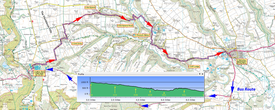
- (Start) On Summer Sundays, park your car in Helmsley and catch the M4 Moorsbus to Sutton Bank. At other times you must make alternative travel arrangements.
You could now simply follow the Cleveland Way back to Helmsley, but letís take a slightly more devious route! Head east across the car park from the visitor center to a footpath sign. Go through the gap and cross the road to a footbridge leading into woodland. Turn left (SP Hambleton House) following the path along the edge of the wood. After swinging right, the path picks its way through a delightful mix of young trees, crosses a bridle track, to arrive at a farm track. Turn left and head towards Hambleton House, then right along an enclosed path (Cleveland Way) between paddocks and then alongside woodland. At the end of the next field the bridleway turns 90o left along the field side to a gate opening onto a walled track, which takes you to the road at Cold Kirby. Turn right into the village and arrive at the green where there is a seat.
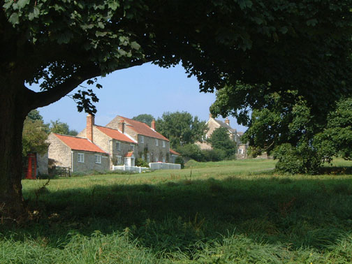
- (2.8km, 1ĺ miles) Numerous paths radiate from Cold Kirby. At the triangular green take the left fork(not the Cleveland Way)then turn left again as indicated by a bridleway sign, to walk up a gravel drive between houses to a gate by the barn at the rear of the property. This leads into fields. You drop down passing a drinking trough and round to a gate into the next field. It can be muddy hereabouts and there may well be cattle in this field. Keeping along the left-hand side of the field - although deviations might well be needed to avoid the mud - you arrive at a gate onto the Old Byland road. Turn right here and enjoy the next mile as you stride down the lane into the village. There are wide ranging views with prominent to the north the dome shaped Easterside Hill and beyond that Bilsdale TV Transmitter. The lane dips into Old Byland - note that 'Old' has been added to the sign as an afterthought. Ignore the first bridleway sign, and continue past Valley View Farm (B&B), which surprisingly, is also the home of Ample-Bosoms.com!
- (5.5km, 3ľ miles) At the next bridleway sign (opposite a road junction) in Old Byland go through the gate on the right to drop down bearing left below a wall. A narrow path, slippery in places, somewhat overgrown with nettles in summer, and with a steep drop to your right, gradually descends into a wooded dale - this is probably the most hazardous part of this walk. The shaded upper reaches of this dale do not get much sun, so the valley floor can be quite wet underfoot, but after a gate the valley begins to open out and the walking improves. In about 800m (Ĺ mile) you come to a concrete farm road coming down from Reins Farm. Turn left and follow this track as it climbs steadily out of the dale to meet the road from Old Byland.
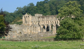
- (7.3km, 4ĺ miles) Turn left up the road for about 100m (100yds) and then bear right down a lane (SP Tylas Farm). At the bottom of the hill double back right along another track which continues down into the valley round to the substantial Bow Bridge - this track must have been of much greater importance in olden days. Continue up the lane from the bridge, passing two stiles clearly marked 'No Right of way', to a gate signed FP to Rievaulx. From this gate walk through the field above the River Rye. In the second field you cross earthworks shown as a 'Canal' on OS maps. The ruins of Rievaulx Abbey are dead ahead. Go through a gate, passing right of a barn and join the road in Rievaulx village. Turn right along the road passing the Abbey carparks to reach the main entrance, information centre and new tea-room, and toilets.This is probably a good place to take a lunch break, and visit the abbey if you wish.(Restricted opening in winter)
- (9.2km, 6 miles) Continue south along the road (care needed - as this road can be busy with traffic to/from the Abbey) to the T-junction at Rievaulx Bridge. Turn left here (back on the Cleveland Way) passing the Old Forge. As the road starts to climb up into woodland a footpath is provided on the RH-side, and this path (Cleveland Way) then branches right up through the woods. Its a long, steady pull up through the trees but eventually the terrain levels out. As the woodland thins you arrive at Griff Lodge.
- (12km, 7Ĺ miles) Here there is a view, right, over Ryedale towards Duncombe Park, but the House remains hidden by woodland. Continue ahead on the Cleveland Way to cross a deep gulley by means of steps down and up. Emerge from the woods to follow an enclosed path round the sides of fields to a gate and a track leading down into Helmsley. The tower of the castle ruins is visible across to the right as you pass the main carpark and toilets, and Ryeburn Tearoom (which also serves excellent ice-cream!) to arrive back in the centre of Helmsley, almost opposite the church. Back on the Market Square, there are several pubs, cafes, and a variety of other shops,and scores of leather-clad bikers.(15km 9ľ miles)
Along the Way
Rievaulx Abbey is, without doubt, one of England's finest ecclesiastical ruins. This Cistercian Monastry was founded in the 12th century, and the roofless shell that stands today still cannot fail to impress. It is now in the care of English Heritage.
Rievaulx village is itself attractive with some thatched cottages - unusual for these parts. On the hillside, above the village and Abbey, is Rievaulx Terrace with its two Ionic Temples dating from 1758, now in the care of the National Trust.
Arnold Underwood & Denise Middleton (Sept 2005, updated July 2006, Mar 2008, April 2015, Jan 2019)
|