
|
LINCOLNSHIRE WOLDS - Tealby - 15.2km (9Į miles)
Tops and Vales
In the middle ages there were up to dozen watermills in Tealby with paper making a major industry. Today the village is haven of tranquillity with its narrow streets and stone-built cottages with their colourful gardens. Papermill Lane and Papermill Cottages give clues to its industrial past.
This part of the Lincolnshire Wolds is well-endowed with permissive paths and access land through the Countryside Commission Stewardship Scheme and this walk takes advantage of this.
The hilltop church at Walesby, known as the æRamblers ChurchÆ because of its stained-glass window dedicated to walkers and cyclists. The church is only used on a few special occasions but is always open and this route follows the Viking Way past its door.
Fact File
|
Distance
|
15.2km (9Į miles)
|
|
Terrain
|
Good field paths and bridleways, and country lanes plus one short section of busy road.
|
|
Time
|
4Į hours
|
|
Stiles
|
2
|
|
Grading
|
*** moderate
|
|
Suitable for
|
all, but take care needed crossing the busy B1225 road
|
|
Start/Parking
|
Tealby Village Hall (Honesty box for donations) Grid Ref: TF 158908 |
|
Nearest Town
|
Market Rasen
|
|
Refreshments
|
Tearoom and pubs in Tealby. Hot & cold drinks also available from the Village Shop in Tealby
|
|
Toilets |
none
|
|
Public Transport
|
None Convenient; Service 3X one each way, from Market Rasen and Louth serves Tealby on request (Call 0845 2343344)
|
|
Map
|
OS Explorer 282 (Lincolnshire Wolds North)
|
Route created using TrackLogs Digital Mapping
Image reproduced with kind permission of Ordnance Survey and Ordnance Survey of Northern Ireland.

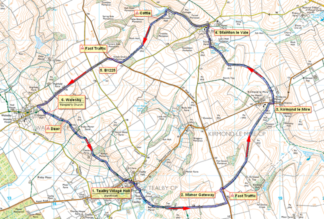
- (Start) From the village hall turn left and head down Beck Hill to the ford and footbridge across the River Rase. Continue straight ahead following the Viking Way into the grounds of Bayons Manor, demolished in the 1960Æs. The route continues on a cinder track steadily up hill. Where the Viking way turns south, this walk keeps along the track which becomes a permissive path to the B1225 road. Do not go onto the road, because our permissive path goes left alongside the hedge. This mown strip along the field side brings you to the ruins of a stone gate-way, a former entrance to Bayons Manor from High Street.
- (2.4km/1Įmiles) Here cross the road with care and take the driveway towards Kirmond Hall. About 800m down the lane, go through the gate on the left to descend a green vale towards Kirmond-le-Mire. After passing through another gate you encounter an area of boggy ground (the Mire?) after which you bear left to a gate in the corner to emerge on the road at Kirmond-le-Mire. Walk down the pavement until opposite the old manor. Cross the road and go through the gates leading past the derelict buildings of the old manor.
- (4.8km/3 miles) Leaving the buildings behind, the path continues as a grass strip across a large arable field. At the next field ignore the permissive bridleway left and continue ahead up the field edge into a small wood. Here there is surprisingly short steep descent to come alongside another wooded area where it can be wet underfoot due to the proximity of springs rising from the hillside. At a bridleway sign before a cottage on the left, the path leaves the farm track and cuts across to emerge through a gap in the hedge onto the road near South Farm. Walk down the road into Stainton-le-Vale where there is a seat on the green.
- (7.6km/4Š miles) Continue a short distance up the road and turn left at the T-junction. This narrow road is now followed for about 1km under a canopy of trees to Stainton Hall. Here the trees give way to a large area of a beautifully maintained green where mature trees stand aside the driveway to the Hall. A row of cottages and the Estate Office overlook the green. The route goes left behind the buildings passing a fishing pond to enter a large field with warnings regarding cows with calves, and of a bull. A stony track leads back up onto the Wolds (ignore track forking right). The cattle might be inquisitive but otherwise keep their distance. After a gate, the hill begins levels out and you pass an area of dense woodland to reach the B1225. This road is busy and carries fast traffic.
- (10.4km/6Į miles) Turn right along the verge facing oncoming traffic then, before the road dips, where you have reasonable visibility in both directions quickly cross to the other side and keep on the verge to the junction for Walesby. You now have about 1.5km of road walking down to Walesby. The road carries a fair amount of traffic but is wide and straight so this is not a major problem. As you near Walesby, the hilltop church comes into view on the left. Just before the 30mph signs a permissive path enters access land over a stile. Cross a plank bridge over a stream and head straight up the hillside to another stile. Turn left up the track and into the churchyard of the æRamblersÆ ChurchÆ.
- (12.8km/8 miles) Here you are back on the Viking Way and itÆs simply a matter of following this back to Tealby. At the next field you may be surprised by the very high fence and gate. This is because you are entering an area where red deer are farmed. The path drops steeply down through scrubland to another gate in the deer fence. After crossing a footbridge you are faced with an equally steep climb up the other side. Cross the driveway to Risby Manor and after another gate walk above a pond up towards woodland. Here you will likely see a flock of ærare-breedÆ Lincoln Longwool sheep. After a narrow path alongside the wood you come out into the open by the appropriately named Castle Farm. The path swings left, avoiding most of the nettles, and drops down into a shallow valley. It can be boggy here but a boardwalk is provided across the wettest area. Tealby is now visible ahead and in the next field keep left to the higher path at a fork to arrive in the village on Rasen Road. Cross over, turn left a walk up and round the corner passing the church and then bear right to bring you back to the village hall.

Bayons Manor was a 60-roomed Gothic mansion surrounded by a moat with drawbridges and crenellated towers and once owned by Charles Tennyson, later Tennyson d'Eyncourt, the uncle of Alfred, Lord Tennyson.
The estate was purchased in 1944 by a local farmer, primarily for the farmland as the house was already derelict and becoming dangerous. Because of its dangerous condition the buildings were subsequently demolished in 1964 ¢ a sad end for a rare example of Victorian architecture. Today a bungalow sits on the site of the Manor and the crumbling remains of the stone gate piers stand by the B1225 High Street.
Arnold Underwood (July 2012)
|
