|
NORTH YORKSHIRE - Howardian Hills - 16km (10miles)
'Castle Howard Re-visited'
This is a pleasant walk in the Howardian Hills Area of Outstanding Natural Beauty û a fact proclaimed on the many signposts. This circuit uses parts of the clearly signed Centenary Way and Ebor Way, as well as some less well-used field paths, which may test your route-finding skills.
Fact File
|
Distance
|
16km (10 miles)
|
|
Terrain
|
Undulating field paths and woodland bridleways with some marshy areas.
|
|
Time
|
4¢ hours
|
|
Stiles
|
5
|
|
Grading
|
*** Moderate
|
|
Suitable for
|
all û Be aware of horses on the bridleways
|
|
Start/Parking
|
Parking area on the Avenue near Coneysthorpe crossroads, adjacent to the Great Lake at Castle Howard (grid.ref: SE 707 712) |
|
Nearest Town
|
Malton
|
|
Refreshments
|
Bay Horse Inn, Terrington (Alas, this pub is closed and up for sale - Sept 2012) and 'Back 'o' the Shop' Cafe & Gallery, Terrington
|
|
Toilets |
none on the route
|
|
Public Transport
|
Stephensons 183/184 (not Sundays) - two buses from Malton serving Castle Howard & Terrington.
|
|
Map
|
OS Explorer 300 Howardian Hills & Malton
|
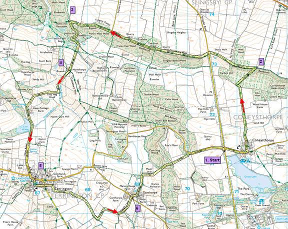

Route created using TrackLogs Digital Mapping
Image reproduced with kind permission of Ordnance Survey and Ordnance Survey of Northern Ireland.

- (Start) From the parking area cross the road, pause to admire the view of Castle Howard across the lake, and then walk back to the crossroads and turn right for Coneysthorpe. Walk along the road for about ╝ mile to Coneysthorpe and there turn left up the side of the large village green. For the first leg of this walk you follow the Centenary Way. Go past the small chapel onto a track, which dips to the left then follows a straight course up the side of fields towards the wooded Coneysthorpe Bank. At the wood the path turns left then right. æNo Right of WayÆ signs ensure that you do not go astray. You are now faced with a steady climb up the wooded hillside.
- (2.8km/1¥miles): You emerge from the wood on top of the ridge where there are extensive views north over Ryedale to the North York Moors. Turn left here, to follow the Centenary Way along the ridge towards Slingsby Bank. At this road continue straight on along the woodland fringe. In fact you will maintain this direction for a couple of miles, crossing straight over the next lane (SP Baxton Howe).
- (4.9km/3miles): Continue along the ridge until Wath Wood appears on the right. Here a bridleway (no signpost), initially overgrown doubles back left. Persevere and things improve, as the path swings round Hollin Hill into more open country with views across towards Airyholme Farm. Turn left at a junction of paths, then at the edge of the wood go right down a very sandy track passing ponds on either side. Continue straight ahead towards Howthorpe Farm on the bank-top ahead. Here there is a choice of several routes to Terrington.
- (7.1km/4¢miles): Go to the right of the farmhouse where a small stile gains entry to a field and walk down to another stile (footpath SP). Your target now is diagonally across the next field û a stile by a gate in the bottom corner, by a stream, Wath Beck. Cross the stile, and walk along the bottom of the field adjacent to the beck û again it can be quite wet underfoot. Halfway along the field edge the path turns right to cross the beck by a well-constructed ædouble-footbridgeÆ. Opposite the footbridge a clear path heads straight up a hillside. From the top there are good views all round. From there the path goes through a gate and drops down to join a bridleway near Rose Cottage. Take the diversion behind the wall, past a tennis court, and back onto the lane. Pass Low Water, which may have originally provided the power for the former sawmill, now Sawmill Cottage and up the lane into Terrington.
- (9.4km/5¥miles): Seats on the village green provide a good spot for lunch. Alternatively, The Bay Horse public house is down the road to the right, but being walkers with muddy boots I suggest you go via the back way! Just across the green a narrow alleyway leads between houses through to South Back Lane. Walk down this lane and you come the rear of the Inn with its car park and beer garden. To continue the walk, take the alleyway through to South Back Lane and walk down to its junction with Mowforth Lane. Here continue across into South Back Lane (East). Just past the last cottage a footpath sign indicates the way across fields to Ganthorpe.
- (10.8km/6¥miles) Cross over the road, by the tiny triangular green with its horse chestnut tree and walk past Ganthorpe Hall. At a bridleway sign turn left and head down through trees passing several small ponds. Go through a gate (Bull in field warning) and along a muddy track by a small wood. Take the footpath right through a small gate and walk straight up the cultivated field towards the wire fence at the top. Turn along by the fence to another gate into open pasture. Straight ahead across the dip can be seen a gate in the Estate wall below a wooded ridge. Head downhill and go through this gate, making sure it is secure behind you. The path continues along a wide ride through the woods, to climb surprisingly steeply up through the trees to a stile into open fields. From here you can look down to where your car is parked with Castle Howard Lake beyond. Head straight down the field towards the bottom corner of the woodland on the left û you may just be able to see a white gate in the wall û aim for this. But this gate is not your exit û just before it, a footbridge takes you left, into the wood by an oddly placed footpath sign from where a narrow path weaves through the trees to the road. Turn downhill to the crossroads and the parking area opposite the lake. (16km/10miles)
Along the Way
Castle Howard
Castle Howard, with its immense faþade, is one of EnglandÆs grandest and best-known houses. Designed by Sir John Vanbrugh and built between in 1699 and 1726, for the 3rd Earl of Carlisle, it has remained the home of the Howard family for 300 years.
Terrington
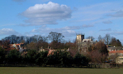
An attractive village largely built of local stone in the 18th and 19th centuries, with a triangular green at its western end. .
Arnold Underwood (Oct 2004, July 2006, minor ammendments Sept 2008)
|
