
|
North York Moors - Hawnby 12.0km (7Ẅmiles)
'Twin Peaks'
A freak of geology at the end of the ice-age left two free-standing hills in the valley of Ryedale between the otherwise flat plateaus of the North York Moors. These two hills just north of the little village of Hawnby, are Easterside Hill and Hawnby Hill, which I have christened Hawnbys Twin Peaks.
This may be only a short walk but it does include climbing up and over both of the twin peaks and crossing open moorland, so choose a fine weather day!
Fact File
|
Distance
|
12.0km (7Ẅmiles)
|
|
Terrain
|
Field & moorland paths and tracks. Two quite steep ascents/descents
|
|
Time
|
4 hours
|
|
Stiles
|
6
|
|
Grading
|
*** Moderate
|
|
Suitable for
|
all - but with two steep climbs
|
|
Start/Parking
|
Hawnby on verge near Church (SE537 896) or behind Village Hall (SE542 893) |
|
Nearest Town
|
Helmsley
|
|
Refreshments
|
Shop and tea-room in Hawnby, award-winning pub The Inn at Hawnby
|
|
Toilets |
None
|
|
Public Transport
|
Moorsbus M9 from Helmsley (Sundays & BH March Oct; also Wed July - Sept)
|
|
Map
|
OS OL26 North York Moors West
|

Route created using TrackLogs Digital Mapping
Image reproduced with kind permission of Ordnance Survey and Ordnance Survey of Northern Ireland.

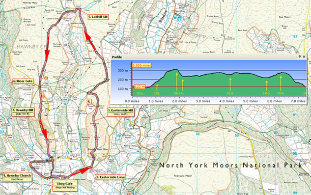
- (Start) Walk back along the lane from the church to road junction just past the village hall and the tea-room. Opposite, a footpath sign points the way across fields towards Easterside Hill which dominates the view ahead. In the third field turn left to head up hill following the power lines. At the top of the field look for a stile near a boggy area. Cross stile and walk through the woodland and across the next field to come out on a road next to Easterside Farm. Easterside Hill now looms just ahead.
- (1.6km/1mile) Almost opposite another sign points directly towards the hill. Walk up the field to a stile in the top corner. Over the stile you leave farmland and enter moorland flora - bracken, heather and bilberries. The waymarked route is not as on the OS map. Follow the clear path which bears left and climbs steadily up the west flank of the hill. Retrospective views over Hawnby open out. Its a steady plod up the hill until the gradient levels out to cross the flat top of the hill. The path crosses the hill and then drops down the eastern side. However the true summit of the hill is further north and this being access land you can strike out through the heather. (This option is best avoided if you are concerned about the steep descent off the hill, or during nesting time for grouse and other moorland birds) Try to keep to any faint sheep tracks and pick your way towards the summit cairn (310m above sea level) which is towards the north end of the hill. A good guide is the Bilsdale TV mast, which is actually several miles further on!
- (3.2km/2miles) At the cairn you can see Hawnby Hill to the west and Bilsdale to the north. From the cairn walk across to the edge of the steep north-east flank of the hill. Down below you should see a wall corner. Pick your way carefully down the steep hillside, zig-zagging to ease the gradient. Where the gradient begins to level out, head through the bracken towards the wall corner. It is possible to squeeze through a gap between a fence post and the wall to regain the footpath. If you kept to the earlier path across the hill, you would also arrive at this point.
- (3.6km/2ỳmiles) The path continues north alongside the wall, curving round to the west to meet other paths by a gate in the wall. Do not go through the gate, although you may need to check the waymark on the other side as this gives a clue to the direction you need to take next! You should head away from the gate on a faint path NE through the heather. This brings you to a gate in the boundary wall on the eastern side of the moor. Again, do not go through the gate but head north alongside the wall. In about 200m turn left opposite another gate and follow the track NW across the moor. (Note: the tracks on the ground do not always match those on the map!) Continue across the moor and the track merges with a well-made track for grouse shooting which drops down to ford Wetherhouse Beck near its confluence with Ladhill Gill. This shallow little valley provides a sheltered spot for a break. To the north, Bilsdale mast now looks surprisingly near, but it is still more than a mile away.
- (6.8km/4ỳmiles) From the Ladhill Gill continue up the track and through a gate back onto moorland. Over the wall on your left there is a good view of the twin peaks. Its easy walking now on the good track which swings south and makes a bee-line for Hawnby Hill. In no time at all you reach the road by the cattle grid at Moor Gate. The Hill looms up ahead, whilst Bilsdale mast now seems a long way off.
- (10.0km/6ỳmiles) Along the ridge you pass a cairn (294m) after which he ground starts to decline and Hawnby village comes into view down below. The gradient steepens and the path zig-zags down through the bracken. Keep to the well-used path through gates to reach a stony track which decants you into the village opposite the Hawnby Inn. You now have a choice of routes round the village depending on where you have left your car. To reach the village hall and tea-room continue straight down the road and turn right at the next junction; to reach the church, turn right and walk along the lane from the Inn turning left at the junction down to the church (12.0km / 7Ẅmiles)
Along the Way
Hawnby
On Sunday 19th June 2005 more than a month's rainfall (70mm) fell in under three hours on the North York Moors above Hawnby. This created a flash flood which came down Ryedale with tremendous destructive force.
The church was flooded and many of the headstones in the churchyard were laid flat.
In Hawnby village, the bridge and several properties were badly damaged. The devastation continued into Helmsley and beyond.

Arnold Underwood (June 2011)
|
