|
EAST YORKSHIRE - Winter on the Wolds
A Walk from Warter
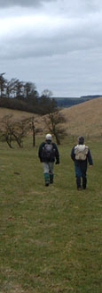
An ideal walk for winter that follows grassy paths and farm roads up onto the Wolds with wide ranging views across the rolling landscape of the Yorkshire Wolds.

Fact File
|
Distance
|
13.5km/8Ẅ miles |
|
Time
|
4 hours
|
|
Grade
|
** moderate
|
|
Map
|
OS Explorer 294(Market Weighton & Yorkshire Wolds Central)
|
|
Start/Parking
|
Small lay-by next to the pond in Warter (Grid. Ref: SE 872 504). Also small car park in the village by the school: 869 503)
|
|
Terrain
|
Field paths, bridle-ways, and minor roads.
|
|
nearest Town
|
Pocklington
|
|
Refreshments
|
none |
|
Toilets |
none
|
|
Public Transport
|
East Yorkshire Buses - just two 'EastRider'45A York-Bridlington buses each way morning & evening serve Warter. 199 'Shoppers Bus' to Pocklington (Tues only), None convenient for walkers. No Sunday buses |
|
Suitable for
|
everyone.
|
|
Stiles
|
2 (can be avoided by using access land)
|
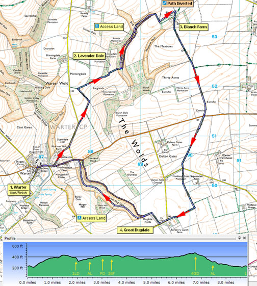

Route created using TrackLogs Digital Mapping
Image reproduced with kind permission of Ordnance Survey and Ordnance Survey of Northern Ireland.

- (Start) From the pond in Warter turn immediately left up the minor road towards Huggate. Follow this road for about 800m (Ẅmile) to where it turns left. Here continue straight along a bridleway with a dale down to your right. At the field corner turn left as indicated and continue along the field side to another way-mark at the next corner. Here turn acutely right to follow the grassy bridleway gradually down hill passing belts of woodland. Round the corner of the wood go through the righthand metal gate and walk down the field side to the edge of Lavender Dale.
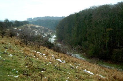
- (3.2km, 2 miles) Go through gate and straight down the steep bank to the dale floor.
This dale isAccess Land - it is now possible to walk along the dale floor, through a new metal gate, bearing right at a water tank up to the gate at the head of the dale.
Alternatively the actual right-of-way is up the opposite side of the valley to find a track. Turn left to follow this track which heads diagonally up the hillside to the top of the valley side. Walk along the top with panoramic views up and down the dry valley. Continue forward through another gate, keeping just below the hawthorn bushes.
At the end of the dale turn right through a gate at the field corner to follow the field side to a belt of woodland. Turn sharp left alongside the woods to the farm access road. Turn right along the farm road to pass the farmhouse at Blanch Farm.
- (4.8km, 3 miles) Continue ahead following the Minster Way along the concrete road, which heads up over a gentle rise. Just past a small wood the road and Minster way turn left. Here continue straight on (footpath) along a stony farm track to arrive at the B1246 road. Cross with care, as traffic is fast along this straight road. The way continues as a grassy path along the edge of fields reaching a minor road at the end of a plantation. Cross the road and continue through the gate opposite along the field side towards the next belt of trees. Turn right here (Waymark) and walk by the trees to reach another gate and another minor road at a bend.Continue forward along the road for about 100yds to a footpath sign on the right
- (9.6km, 6 miles) Follow this path down the edge of the field and round the corner. Here a metal gate opens onto Access Land.It is possible to go left into Great Dugdale, and walk down the length of this green valley to the main road. Alternatively, the right-of-way continues along the top by the fence, and the valley of Great Dugdale gets ever deeper down to your left. Your gradual descent along the top of the dale leads to a stile into Townend Wood. The path now descends quite steeply through the trees (care needed) before swinging right and dropping more gently down to a stile and the main road.
Turn left, and walk along the road back to Warter. Again take care - face and make yourself visible to oncoming traffic and walk on the verge wherever possible.
Along the Way
Warter is a small estate village nestling in a wooded hollow on the edge of the Yorkshire Wolds. Bordering the village green are picturesque cottages, some being thatched. The church with its slender spire, on a hill beyond the pond, stands next to the site of an Augustinian Priory.
In Great Dugdale just down from the access gate, notice the large boulder perched on the top of the valley side (a glacial erratic?)- investigate more closely if you wish.
Arnold Underwood & Caroline Gowthorpe (Jan 2004), Revised March 2006, Sept 2020
|