|
NORTH YORKSHIRE - Washburn Valley
'Reservoir Roundabout'
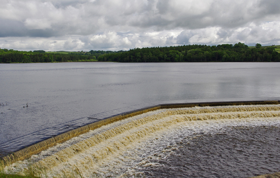
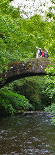
This walk takes in some of the best of the Washburn Valley, all the more so with the woodland in autumn colours. After walking along the shore of Swinsty Reservoir, the river is followed to an ancient pack-horse bridge, Dobpark Bridge. The bridge sits in woodland setting below the ruins of Dobpark Lodge, which is just visible above the trees.
Fact File
|
Distance
|
12.5km (8 miles)
|
|
Time
|
4 hours
|
|
Map
|
OS Explorer 297 Lower Wharfedale/Upper Washburn Valley
|
|
Start/Parking
|
Swinsty Moor Car Park (Yorkshire Water)
|
|
Terrain
|
Field & woodland paths, bridleways and minor roads
|
|
nearest Towns
|
Harrogate and Otley
|
|
Refreshments
|
The Timble Inn, in Timble; Washburn Heritage Centre, Fewston Church (weekends)
|
|
Toilets |
at start/finish
|
|
Public Transport
|
None
|
|
Suitable for
|
all
|
|
Stiles
|
8
|
- Start: Return to the car park entrance and turn right down the road which crosses the Fewston Reservoir embankment. There is a pavement on the left-hand side of the road across the embankment. At the far end, cross to the right to pass through a gap in the wall and gain a concessionary path along the eastern side of Swinsty Reservoir. In a further km you must leave the waters edge and cut through a car park and turn right along the road. This crosses a short embankment at the end of which you go through a gate to rejoin the path along the side of the reservoir. Ahead can be seen Swinsty Reservoir embankment.Go through a gate to follow a patht down the rough hillside, above a pipeline, towards a wall. Near the middle of this wall is a step-stile. Climb over this into a field. Continue forward along the right edge of several fields with the River Washburn to your right.
- (4.8km, 3 miles) At a farm track by a bridge should turn left up the tracktowards Folly Hall. There is a distinct lack of signs and waymarks in this area. As you approach the gate into the farm-yard, bear right along a narrow path through the trees. This leads through a gap in a wall into open pasture and avoids walking through the farm. Walk up the field and swing right to join a track (bridleway) leading to another new gate in the corner. The track continues along the top edge of fields through two more gates, then switches to the left to arrive at the last gate and a narrow lane by Mill House Farm.(An alternative is to go through the muddy yard at Folly Hall Farm and follow the rough farm road to a minor road. There turn right and head steeply down Hanging Bank to Mill House Farm)
- (8km, 4Ẅmiles) Take the 'low road' and just past the farm bear right down a rough track. This leads down to the river and a delightful pack-horse bridge, Dobpark Bridge. This bridge provided access to Dobpark Lodge, the ruins of which are just visible above the trees. Turn left immediately after the bridge to follow the river back up stream. Keep near the river crossing stiles to keep to the side of fields, and eventually crossing a stream and entering woodland. Bear right to follow a path through the trees back towards the river. Walk in company of the river for about Ẅ mile when the path bears left to negotiate a footbridge over Timble Beck. The modern wood and steel bridge has replaced the miniature pack-horse bridge built in 1969 by the West Riding Ramblers in memory of Arthur Adamson which was swept away by floods in 2009. Ironically it in turn had replaced an earlier bridge destroyed by floods!
- ( 9.5km, 5Ẅmiles) After the bridge turn left to follow Timble Beck up stream. At the end of a wall you begin a steady climb above the beck. Again there is a lack of waymarking, but continue up above the tree-lined slopes of the Gill and as the ground levels out you should pick out the way ahead by the notices next to a stile. From here to Timble the route is clearly marked by yellow-topped posts at regular intervals - this land-owner intends that you keep to the right-of-way, and we should be grateful for that. At the second field the path switches sides and continues with the wall on your right to an awkward stile onto a lane. Turn left, passing the impressive Book End Farm, and walk into Timble. This little village is situated on a hilltop overlooking the Washburn valley and Blubberhouses Moor. At the green turn right and in 50yards, opposite the village hall, is the unspoilt Timble Inn.
- (11km, 7 miles) Return to the green and take the path signed 'Blubberhouses'. Keep along the side of three fields, then at the next bear right passing close to Ridge Top Farm to a gate and a road. Cross over and enter Beecroft Moor Plantation. Do not follow the main path, but bear half-right on a faint path through the trees. There are occasional way-marks, but the path is indistinct in places and there are twists and turns to avoid obstructions. Eventually you fall out of the trees onto a forest track. Turn right and follow this to T-junction with another track. Cross a stile opposite and continue along a field side. Bear right and continue along the next two fields to come to a road near White Crag. Turn left down the road to arrive back at the car-park.
Along the Way
The impressive Dobpark packhorse bridge dates from 1767 and stands next to a ford across the River Washburn . Timble village sits in a commanding position overlooking the valley. It has a number of cottages dating from the 17th century. The quaint Timble Inn, after been closed for a few years, has been thoroughly modernised and is now a very popular 'eating' pub with luxury accommodation.
In 2011 an extension to the Parish Church in Fewston village was opened to accommodate the Washburn Heritage Centre. The Centre stages exhibitions and events throughout the year, and at weekends becomes a tearoom serving teas and home-made cakes.
Arnold Underwood (Sept 2002, updated May 2025)
|