
|
YORKSHIRE WOLDS: Wayrham
On the edge of the Wolds
A quiet unspoiled corner of East Yorkshire that is oblivious to holidaymakers making for the coast along the A166. After crossing this busy road you will soon leave the hustle & bustle behind as you enter a world of secret dales and sleepy villages.
This is a good walk at any time of the year on the fringes of the Yorkshire Wolds via Kirkby Underdale – a delightful estate village owned by Lord Halifax of nearby Garrowby Hall. The walk promises a mix of wide ranging views, hidden valleys and woodland. Birdwatchers should keep a lookout for buzzards and red kites
Fact File
|
Distance
|
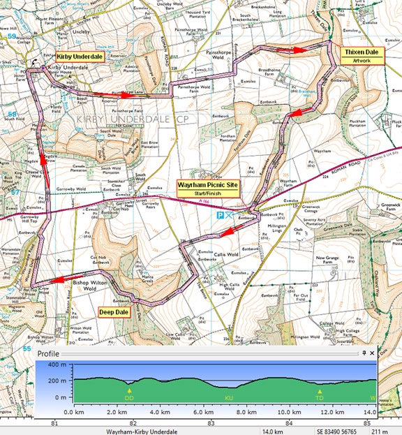
14.4km (9 miles)
|
|
Time
|
4 hours
|
|
Map
|
OS Explorer 294 (Market Weighton & Yorkshire Wolds Central)
|
|
Start/Parking
|
Wayrham Picnic site (off A166) Grid Ref: SE 834 567
|
|
Terrain
|
Field paths, bridleways & minor roads; one steep descent and ascent in and out of Deep Dale.
|
Grade
|
*** (moderate)
|
|
Nearest Town
|
Pocklington
|
|
Refreshments
|
None
|
|
Toilets |
None
|
|
Public Transport
|
None
|
|
Suitable for
|
for everyone.
|
|
Stiles
|
8
|
Route created using TrackLogs Digital Mapping
Image reproduced with kind permission of Ordnance Survey and Ordnance Survey of Northern Ireland.

- (Start) From picnic area carpark head left to find a stile up a bank among trees. Walk up left side of field to a gate. Through the gate turn right and walk with hedge on your right (this is a permiisive path on the opposite side of hedge to the r-o-w shown on OS maps). Go right then left through gates onto tractor track to road. Turn left and walk 400m to a footpath sign on the right. Walk down the side of field then past woods to a gate opening out onto a steep-sided dale. (This is open-access, and you could pick your own route through the dales up to Cot Nab on Bishop Wilton Wold) However, the right-of-way continues along the top until eventually you have to descend. Take care, it is steep grassy slope that leads you down into Deep Dale.
- (2.8km/1ľ miles) No sooner are you down in the dale than you must start the climb up! Steep steps head up the bank to a forest track. This climbs steadily upwards through the trees onto Bishop Wilton Wold. At the road, cross straight over and head down the side of a field to junction of paths at corner of a wood. Here continue down alongside the trees then right along a narrow path between wire fences, high above Worsen Dale. There are views across Bishop Wilton and the Vale of York. The path decants you through trees onto a minor road which is followed up to the A166 at the top of Garrowby Hill. Hereabouts you are close to the highest point of the Yorkshire Wolds - just over 240m (800ft) above sea level – the ‘County Top’ of the East Riding. The A166 carries fast traffic and is popular with bikers, so take care crossing to the farm track opposite. This track heads north across Garrowby Wold. Beyond a gate there starts a long descent from Megdale Brow down to Kirby Underdale. After passing barns you arrive at a corner of this delightful little village.
- (7.6km/4ľ miles) Turn right through the village. By keeping to the pavement on the left you are taken down to the church, which is worth exploring. Leave the churchyard by the lych-gate and continue along the lane for about 200m, then take a footpath on the right that takes you straight up the hillside above a pond, with Painsthorpe Hall to your left. Join a farm track and continue uphill through the hamlet of Painsthorpe to rejoin the road. It is now a steady plod uphill for nearly 1km to the road junction at the top. However near the top, Painsthorpe Dale on the left is open-access, and provides a pleasant spot for a lunch break in the shelter of trees. At the road junction turn left, then right along a farm road across Painsthorpe Wold. Where this road turns right continue ahead on a bridleway which leads down to the head of Worm Dale. Go through the gate and into the dale, narrow initially but it soon widens. You are likely to encounter highland cattle here, and although they appear intimidating they are quite gently and respond, albeit slowly, to requests to moo-ve over.
- (11.6km/7Ľ miles) Where Worm Dale meets Thixen Dale you will come across a dewpond and an earthwork sculpture – part of the WANDER Art on the Wolds project. Turn right up the dale coming to a wire fence and gates. Here waymarks seem to insist you go left, but ignore these and take the path leading into the dale to the right, Bradenham Dale. Waymarks on the next gate confirm you are still on a right-of-way. Somewhat unusually for the Wolds the dale now become densely planted with conifers, creating a claustrophobic feel. At a clearing, fork left into Wayrham Dale and continue up through the trees to a gate into the open once more. Keep to the bottom of the dale until you have to head up to gate on the right where the A166 cuts across the top of the dale. Cross the road with care and walk down the bank to the picnic area and car park.

Along the Way
All Saint’s Church, Kirby Underdale which dates from the 12th Century, is situated in a picturesque setting overlooking Kirby Beck - in early spring the churchyard is a delight firstly with snowdrops, and then daffodils.
Interesting features of the church are a stained-glass window dedicated to the Halifax family and a 3rd century carving of the the roman god Mercury, incorporated in a buttress of the north aisle.
Waves and Time (WANDER - Art on the Yorkshire Wolds Way). The artist Chris Drury's concept for this artwork was imagining the ancient flow of ice and water through the area and how this created the landscape we see today. The artwork is at the junction of three dales and the spiral suggests how an eddy might have formed to create the open space. The project also involved the restoration of a dew pond using traditional methods.
Arnold Underwood (Nov 2012)
|
