
|
NORTH YORK MOORS – 17.6km (11 miles)
BLAKEY RIDGE & WESTERDALE
Moorland paths take us via 'Fat Betty' down into the green valley of Westerdale.From there the route follows the course of the infant River Esk up past Esklets to join the former Rosedale Railway for brisk stroll back to a deserved pint at the Lion Inn
A good walk for spring before the bracken takes over!
Fact File
|
Distance
|
17.6km (11miles)
|
|
Terrain
|
Moorland and field paths & bridleways
|
|
Time
|
5 hours
|
|
Stiles
|
4
|
|
Grading
|
**** Quite strenuous
|
|
Suitable for
|
Keen walkers
|
|
Start/Parking
|
Near the Lion Inn, Blakey Ridge 1000ft above sea level Grid Ref: SE 679 997 |
|
Nearest Town
|
Pickering
|
|
Refreshments
|
The Lion Inn
|
|
Toilets |
|
|
Public Transport
|
Moorsbus in summer months (Sun & Bank Hols, May-Oct; Daily, July-Aug)
|
|
Map
|
OS Explorer OL26 North York Moors (West)
|

Route created using TrackLogs Digital Mapping
Image reproduced with kind permission of Ordnance Survey and Ordnance Survey of Northern Ireland.

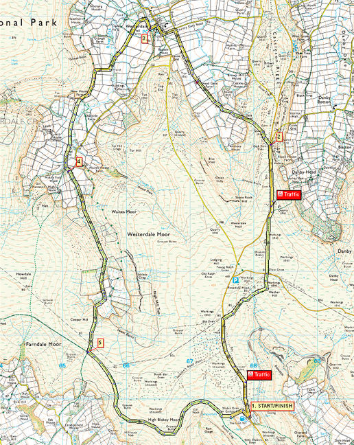
- (Start) Cross the road with care and head north towards Castleton along the road-side. There is a strip of close-cropped grass to walk on to keep you off the tarmac. After about ˝ mile a footpath strikes off right across the moor. Follow this as far as another road. Cross over to the White Cross, better known as ‘Fat Betty’. Continue on the path across the moor to eventually meet up again with the main road. Continue along the roadside – more care needed here because there is less verge, and a crash barrier. Opposite a road junction a bridleway diverges left down into Westerdale.
- (4.8km/3miles) Cross the road to follow the bridleway down off the ridge. In clear weather there is a panoramic view ahead across Westerdale and beyond. The path cuts diagonally down to a gate and Dale Head Farm. Signs and waymarks clearly direct you left, round behind barns to continue following the bridleway along fieldsides to Broadgate Farm. Go past the buildings onto the farm road. Walk along the lane through this pastoral landscape, past the YHA camping barn on the left. Turn left at cross-roads and walk round into Westerdale village. Note the small parish church on the left, and then turn left down a lane.
- (7.6km/4ľ miles) This narrow lane swings round past Westerdale Hall, with its impressive castellated tower (see below). Keep along this lane for about ˝ mile. It dips to cross the infant River Esk then climbs to a gate in the intake wall around Baysdale Moor. Go through the gate and turn left to follow the track round the hillside towards New House Farm. Just before the farm take the footpath left over a stile (SP Esklets) and head across fields (sheep, cattle, horses) crossing the driveway from Hill House Farm, towards Wood End. Here, the path skirts right, round the buildings, to a stile and brings you to a farm track by a ford and footbridge crossing the Esk.
- (10.8km/6ľ miles) Go left across the river and immediately right (muddy) through trees and bushes to continue on the Esk Valley Way. The Way heads up the valley with the going getting tricky as you pick your way through bracken, bogs, and boulders. However the route is never in doubt, and eventually drops down to cross a footbridge over the Esk. Up the opposite bank the path now crosses a patchwork of walled enclosures – remnants of the former isolated settlement of Esklets. After crossing another of the Esk’s tributaries the path climbs to join a clear moorland track – no doubt providing easy access to the moors for shooting parties! This sandstone track climbs steadily up onto the moor. Ahead on the skyline is a lone signpost – but it takes quite a while to reach it, but reach it you will, to find it situated at the crossing of the old Rosedale Ironstone Railway. Here there are views south into Farndale and north back over Esklets into Westerdale. The old railway snakes across the moor at about 1000ft above sea level, trying to keep gradients to a minimum by following the contours, and cutting and filling to create embankments.
- (13.8km/8ľ miles) Its about 2 miles along the track-bed back to the Lion Inn. The track sweep in a big arc south round the contours of Blakey Moor then back north to avoid the gully created by Gill Wath. At last the tiled roof of the Inn is visible in the distance, but disappears again behind a hill as you get near. A short-cut (marked LWW – Lyke Wake Walk – on a rock) heads left up the hillside to bring you round the back of the pub by way of a boundary stone, marked TD, on Blakey Howe burial mound. From there drop down to the Inn. (17.6km/11 miles)
Along the Way


Fat Betty (White Cross)
One story associated with this 'cross' is that a local farmer's wife, Fat Betty, fell from their horse and cart on a dark, foggy night.
When he arrived home and noticed she was missing from the back of the cart he retraced his route across the moor
and all he could find was the large, squat stone
Photo of Fat Betty thanks to Noth York Moors CAM (Don Burluraux)
At grid ref NZ 67520 01285 near the Lion Inn is another less well-known standing stone, on Blakey Howe. This one is
a Bronze Age stone contemporary with Flat Howe 250m to the north. It has been used later as a boundary marker, thus the initals "TD" for Thomas Duncombe (of Duncombe Hall, Helmsley)
Westerdale
Westerdale Hall is a building located close to the village, designed by Thomas Henry Wyatt, it was originally a shooting lodge mainly for grouse shooting in the late summer and autumn. After World War II it became a popular youth hostel but is now a private residence with many of its external features remaining much as it did when it was built.
Agricultural land and a hall, situated in the Westerdale area, were given to the Order of Knights Templar at an early period in the twelfth century. The property was donated by Guido de Bovingcourt who owned the land, together with other holdings in nearby Baysdale.
The remains of the fortifications of the hall given to the Templars by Bovincourt were situated to the north of the present day Westerdale Hall. The site was excavated in 1960, revealing evidence of a main chamber together with a kitchen, a brewery, animal quarters and a chapel.
Arnold Underwood (with thanks to Joyce Davidson) (Sept 2007)
|
